hidden
|
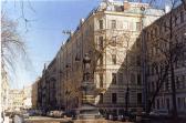
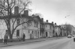
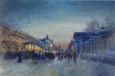
Pushkinskaya Street
PUSHKINSKAYA STREET (until 1881 Novy Avenue, Kompaneiskaya Street), between Nevsky Prospect and Kuznechny Lane. It was named after Alexander Pushkin. The street was built in 1874 and actually is a creation of architect P.Y
|
|
|
|
|
hidden
|
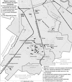
Pushkinsky District
PUSHKINSKY DISTRICT, an administrative and territorial unit of St. Petersburg (with the territorial administration situated in the town of Pushkin, at 24 Oktyabrsky Boulevard)
|
|
|
|
|
hidden
|
Radishcheva Street
RADISHCHEVA STREET (until 1858 - Gospitalnaya Street, until 1935 - Preobrazhenskaya Street, renamed after A.N. Radishchev), between Zhukovskogo Street and Kirochnaya Street
|
|
|
|
|
hidden
|
Razliv
RAZLIV, a locality in southern Sestroretsk, north of Tarkhovka, on the western bank of Lake Sestroretsky Razliv; also a railway station along the Saint Petersburg -Sestroretsk line
|
|
|
|
|
hidden
|
Razyezzhaya Street
RAZYEZZHAYA STREET (in the first half of the 19th century, it was also referred to as Chernyshev Lane), between Zagorodny Avenue and Ligovsky Avenue. The road was named in 1739, constructed in the 1740s following the designs of St
|
|
|
|
|
hidden
|
Regiment Settlements (entry)
REGIMENT SETTLEMENTS are places for compact billets of guard regiments inside the city limits in the 18th - early 19th century. They were built in 1739-43 under regular designs specially provided for this purpose (usually the planning included an
|
|
|
|
|
hidden
|
Relief
RELIEF. Despite having a general plain character, its flatness and large built up areas, the relief of St. Petersburg is diverse and full of contrasts. The highest peaks in the southwest of the city reach 176 meters
|
|
|
|
|
hidden
|
Repina Square
REPINA SQUARE (in the middle of the 19th century - Kalinkinskaya Square), between Rimskogo-Korsakova Avenue and embankments of the Fontanka River and Griboedova Canal
|
|
|
|
|
hidden
|
Repino, settlement
REPINO, a former settlement, known as Kuokkala until 1948; became a municipal unit within the Kurortny District in 1998; 37 kilometres northwest of Saint Petersburg, in a resort area on the northern coast of the Gulf of Finland; also a train station
|
|
|
|
|
hidden
|
Residential Blocks (entry)
RESIDENTIAL BLOCKS, a site development system typical for new city districts built in the 1920-30s. Due to an acute demand for accommodations in the mid-1920s, individual home building was replaced by residential blocks - a new type of city
|
|
|
|
|
hidden
|
Revolyutsii Freeway
REVOLYUTSII FREEWAY (until 1923 Porokhovskoe Freeway), between Piskarevsky Avenue and Kommuny Street. It was named after the October Revolution. The road was constructed in the first quarter of the 18th century as the road to the powder-mill (hence
|
|
|
|
|
hidden
|
Rezvy Maly Island
REZVY MALY ISLAND in the Ekaterinhofka River, downstream the mouth of the Tarakanovka River. It is linked to Gutuevsky Island via a wooden bridge. The island is about two hectares in area, 300 metres long, and 100 metres wide
|
|
|
|
|
hidden
|
Right Bank of the Neva River
RIGHT BANK OF THE NEVA RIVER, a general name of a vast territory on the right bank of the Neva River southwards from the Soyedinitelnaya railway line and the Okhta - Zanevsky Post stretch
|
|
|
|
|
hidden
|
Rimskogo-Korsakova Avenue
RIMSKOGO-KORSAKOVA AVENUE, between Sadovaya Street and Repina Square. Known since 1739 as a part of the road to Ekateringof, in 1770-1923 - Ekateringofsky Avenue. It was renamed after composer N.A. Rimsky-Korsakov
|
|
|
|
|
hidden
|
Rizhsky Avenue
RIZHSKY AVENUE, between Lermontovsky Avenue and the Ekateringofka River. Since 1776, it was known as Izmailovskaya Street (after Izmailovsky Life Guard Regiment quartered nearby), Izmailovsky Avenue and Novoizmailovsky Avenue, St
|
|
|
|
|
hidden
|
Robespierre Embankment
ROBESPIERRE EMBANKMENT (in 1887-1916 Voskresenskaya Embankment, after the Holy Resurrection Church; until 1923 Belgiiskaya Embankment), on the left bank of the Neva River, between Smolnaya Embankment and Liteiny Avenue
|
|
|
|
|
hidden
|
Rubinsteina Street
RUBINSTEINA STREET (from 1739 - Golovin Lane, after house-owner Count F.A. Golovin; from 1798 - Troitsky Lane, after the Metochion of Holy Trinity Lavra of St. Sergius located at 44 Fontanka River Embankment, in 1887-1929 Troitskaya Street)
|
|
|
|
|
hidden
|
Rubleviki
RUBLEVIKI, the historical name of an area to the north-east of St. Petersburg, between Bolshaya Okhta, Polyustrovo and Porokhovye. In 1913, a junction line of Finlyandskaya railroad was built through Rubleviki and the railway platform of the same
|
|
|
|
|
hidden
|
Ruchyi
RUCHYI, an area to the north-east of St. Petersburg, to the north of Piskarevka. It was named after a village located on the banks of Murinsky Stream (the site where it intersects present-day Grazhdansky Avenue) from the late 18th century to the
|
|
|
|
|
hidden
|
Rumyantsevsky Garden
RUMYANTSEVSKY GARDEN (Solovievsky Garden) is located on Vasilievsky Island, on the right bank of the Bolshaya Neva, between the First and Second lines of Vasilievsky Island. The garden was laid out in 1865-67. It was designed by architect N. N
|
|
|
|
|
hidden
|
Rusanovka
RUSANOVKA, an area to the south-east boundary of St. Petersburg, at the end of Oktyabrskaya Embankment, on the site where the Utka River flows into the Neva. The region was named after landlords Rusanov
|
|
|
|
|
hidden
|
Rybatskaya
RYBATSKAYA, a former village, located along the right bank of the Okhta River, four kilometres downstream from the site where the Murinsky Stream flows into the Okhta river
|
|
|
|
|
hidden
|
Rybatskoe, area
RYBATSKOE, an area to the south-east of St. Petersburg, on the left bank of the Neva River, between the Murzinka River and the Slavyanka River. In 1716, Rybnaya (Fish) settlement was founded there at the Peter the Great’s decree
|
|
|
|
|
hidden
|
Ryleeva Street
RYLEEVA STREET (until 1923 - Spasskaya Street), located between Radishcheva Square and Radishcheva Street. The first name comes from the Holy Transfiguration All Guards Cathedral. The street was renamed after K.F. Ryleev
|
|
|
|
|
hidden
|
Rzhevka, area
RZHEVKA, an area in the north-east of St. Petersburg, on the left bank of the Okhta River, to the north-east of Porokhovye. Since the 1730s, the Rzhevskaya Settlement, owned by Captain V.F. Rzhevsky (hence the name), was located there
|
|
|
|
|
hidden
|
Rzhevka-Porokhovye
RZHEVKA-POROKHOVYE, an area of mass residential development in the east of St. Petersburg, between Irinovsky Avenue, Kommuny Street, Khasanskaya Street and Peredovikov Street
|
|
|
|
|
hidden
|
Rzhevsky Forest Park
RZHEVSKY FOREST PARK is located in the Eastern outskirts of St. Petersburg, on the boundary of the district of large scale residential developments in Rzhevka-Porokhovye and Vsevolozhsky District of Leningrad Region
|
|
|
|
|
hidden
|
Sadovaya Street
SADOVAYA STREET (from 1923 to 1944 - Third of July Street, the section from Italyanskaya Street up to Ekaterininsky Canal; from the 1730s to 1887, it was known as Bolshaya Sadovaya Street; the part from Moika River Embankment to Italyanskaya Street
|
|
|
|
|
hidden
|
Sadovaya Street, Malaya
SADOVAYA STREET, MALAYA, between Italyanskaya Street and Nevsky Prospect (the shortest street of St. Petersburg, its length is 179 metres). It was built in the second half of the 18th century
|
|
|
|
|
hidden
|
Salnobuyansky Canal
SALNOBUYANSKY CANAL was dug between the Korabelnaya Embankment of the Bolshaya Neva River and the Pryazhka River in 1804. It separated Matisov Island from Kolomensky Island
|
|
|
|
|