hidden
|
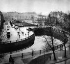
Karpovka, river
KARPOVKA (from Fin. Korpijoki, which means Forest River or Crow River), a river, separating Petrogradsky Island and Aptekarsky Island. The river is 3 kilometres long
|
|
|
|
|
hidden
|
Krasnenkaya, river
KRASNENKAYA, a river in the south-west of St. Petersburg, flowing through Avtovo District and Yugo-Zapad District. The name of the river dates back to 1773, when it was known as Krasnaya Rechka
|
|
|
|
|
hidden
|
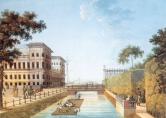
Krasny Canal
KRASNY CANAL (Red Canal) was built between the Moika River and the Bolshaya Neva River in 1711 to drain the territory. It passed approximately along the western part of the Field of Mars
|
|
|
|
|
hidden
|
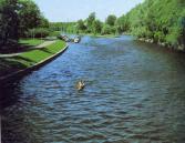
Krestovka, river
KRESTOVKA, a river in the north-west of St. Petersburg, a channel from Malaya Nevka to Srednyaya Nevka. The river separates Kamenny Island and Krestovsky Island. It is 0
|
|
|
|
|
hidden
|
Kronverksky Strait
Kronverksky Strait (Crownwork Strait) is a bow-shaped channel of the Neva River dividing Petrogradsky and Zayachiy Islands. It is over 1 km long, about 50 meters wide and up to 4 meters deep
|
|
|
|
|
hidden
|
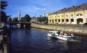
Kryukov Canal
KRYUKOV CANAL runs from the Admiralty Canal by Truda Square to the Fontanka River. 1015 meters long, it was dug from the Neva River to the Moika River in 1719-20 and was named after the contractor Semen Kyukov in 1738 (the section from the Neva to
|
|
|
|
|
hidden
|
Kuzminka, river
KUZMINKA, a river in the south of St. Petersburg between the town of Pushkin and Petroslavyanka. It takes its rise from a swamped lake in Kandakopshino and flows (from the left) into the Slavyanka River upwards from the settlement of Petro-Slavyanka
|
|
|
|
|
hidden
|
Ladoga Lake
LADOGA LAKE, the largest lake in Europe, is located at the border of Leningrad region and the Republic of Karelia. In the old times, the lake was named Nevo (a Finnish word for "sea"), Ladoga (after the old Russian city Ladoga), and Aldoga
|
|
|
|
|
hidden
|
Lakhtinsky Razliv
LAKHTINSKY RAZLIV (Lakhta High Water) is a lagoon-estuary type lake located on the northern bank of Neva Bay and separated from it with a sand bay-bar which has reinforcing that supports a railway line and a highway
|
|
|
|
|
hidden
|
Lapka, river
LAPKA, a river in the east of St. Petersburg, in the area of Rzhevka and Porokhovye. Formerly a tributary to the Okhta River, the Lapka used to flow into the Okhta six kilometres above the mouth of the latter, in the area of the village of Malinovka
|
|
|
|
|
hidden
|
Lebyazhy Canal
Lebyazhy Canal (the Swan Canal) was dug from the Bolshaya Neva River to the Moika River between the Field of Mars and Summer Garden in 1711-19. In 1778, the Canal received its name from swans that lived there and in adjacent ponds (in particular
|
|
|
|
|
hidden
|
Lebyazhy Pond
LEBYAZY POND (Swan Pond), an artificial pear-shaped reservoir located in the western part of Krestovsky Island in Primorsky Victory Park. It received its name from swans living in the pond. Its design was finalized in the middle of the 20th century
|
|
|
|
|
hidden
|
Lesnaya Harbour
LESNAYA HARBOUR (Forest Harbour) is a complex of artificial water constructions including several rectangular cuts located in the southern part of Gutuyevsky Island
|
|
|
|
|
hidden
|
Ligovsky Canal
LIGOVSKY CANAL was constructed to supply drinking water to St. Petersburg under the project of Grigory Skornyakov-Pisarev in 1718-21. Originally, it was 23 km long, 2-4 meters bottom-wide and 1-2 meters deep
|
|
|
|
|
hidden
|
Lomonosovskaya Harbour (the city of Lomonosov)
LOMONOSOVSKAYA HARBOUR is a natural gulf located on the southern shore of the Gulf of Finland in the northern part of the city of Lomonosov (hence, the name) at the head of the Karasta River. It cuts inland for almost 0
|
|
|
|
|
hidden
|
Lubya, river
LUBYA, a river in the north-east of St. Petersburg, in the area of Rzhevka and Porokhovye. The river is also known as Luppa (a distorted version of Izhora word lupyu which means a river littered with timber)
|
|
|
|
|
hidden
|
Malaya Neva
MALAYA NEVA, the second largest (after Bolshaya Neva) branch of the Neva river delta. The Malaya Neva separates from the Neva near the Spit of Vasilievsky Island and flows into the Neva Bay between Dekabristov Island and Petrovsky Island
|
|
|
|
|
hidden
|
Malaya Nevka
MALAYA NEVKA, a branch of the Neva river delta, which splits off from the Bolshaya Nevka near the Spit of Kamenny Island. The river flows into the Neva Bay between Krestovsky Island and Petrovsky Island, converging with the Malaya Neva
|
|
|
|
|
hidden
|
"Marquis's Puddle"
"MARQUIS'S PUDDLE", an ironic local name of the eastern part of the Gulf of Finland between the Neva head and Kotlin Island. The name was coined by Baltic fleet officers in the beginning of the 19th century
|
|
|
|
|
hidden
|
Maslobuyansky Canal
MASLOBUYANSKY CANAL (the Maslyany (Oil) Canal, the Maslyany Buyan Ditch) was constructed in the southeast Vasilievsky Island in the middle of the 18th century. It was named after the now non-existent Maslyany Buyan
|
|
|
|
|
hidden
|
Matisov Canal
MATISOV CANAL is located in the southwest of St. Petersburg westwards from Yuzhno-Primorsky Park. The canal was excavated in the second half of the 20th century in the left bank lows of Duderhof Canal amidst swampy surrounding of Neva Lowland
|
|
|
|
|
hidden
|
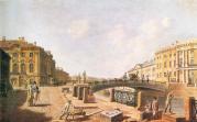
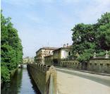
Moika, river
MOIKA (the original name Mya; known as Muya until the early 18th century, derived from the Izhora word for "slush, mire"), a river in the Neva river delta. The Moika River is 4.67 kilometres long, with a width of up to 40 metres
|
|
|
|
|
hidden
|
Monastyrka, river
MONASTYRKA, a river in the south-east of the central part of St. Petersburg, running from Obvodny Canal to the Neva River. The name originates from the monastery located on its banks, Alexander Nevsky Lavra
|
|
|
|
|
hidden
|
Morskoy Canal
MORSKOY CANAL (the Naval Canal) was constructed along shallow waters of Neva Bay between Gutuyevsky and Kanonersky Islands in 1874-85. The Canal has materially changed the islands' shape
|
|
|
|
|
hidden
|
Murinsky Stream
MURINSKY STREAM, a water course in the north of St. Petersburg and a tributary to the Okhta River. The name comes from the village of Murino. The stream heads from Sosnovka Park
|
|
|
|
|
hidden
|
Murzinka
MURZINKA, a river in the north-east of St. Petersburg. In the 1720s, it was named after a country house of the same name. The length is about five kilometres, the width varies from one to three kilometres, at its mouth up
|
|
|
|
|
hidden
|
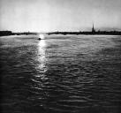
Neva Bay
NEVA BAY is a shallow eastern end of the Gulf of Finland located between the Neva River and Kotlin Island (traditionally referred by citizens of St. Petersburg and sailors as "Marquis's Puddle")
|
|
|
|
|
hidden
|
Neva, river
NEVA, a river in the north-west of Russia, around which the city of St. Petersburg is located at the river mouth. The river issues from the Shlisselburg Bay of Lake Ladoga and enters the Neva Bay of the Gulf of Finland
|
|
|
|
|
hidden
|
Novo-Admralty Canal
NOVO-ADMIRALTY CANAL (New Admiralty Canal) flowing from the confluence of the Moika River and the Admiraly Canal to the Bolshaya Neva was dug in the first quarter of the 18th century
|
|
|
|
|
hidden
|
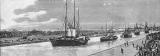
Obvodny Canal
OBVODNY CANAL flows from the Neva River in the area of Alexander Nevsky Lavra to the Ekaterinhofka River (8.08 km long, 21.3 meters wide and 42.6 meters wide in its eastern part)
|
|
|
|
|