Authors
/
hidden
|
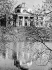
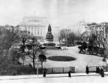
50th Anniversary of October Memorial Park
50TH ANNIVERSARY OF OCTOBER MEMORIAL PARK is located in the north-east of St. Petersburg, in Polyustrovo, between Metallistov Avenue, Revolyutsii Highway and Marshala Tukhachevskogo Street. The total area of the park is 32 hectares
|
|
|
|
|
hidden
|
Alexandrino, forest park
ALEXANDRINO forest park is situated in the southwest part of St. Petersburg, between Narodnogo Opolcheniya Avenue, Stachek Avenue and Kozlova Street. It includes a park which formerly possessed the same name
|
|
|
|
|
hidden
|
Alexandrovsky Park
ALEXANDROVSKY PARK (Pushkin town), a landscape monument, situated to the west of Catherine Park, forming a part of the Tsarskoe Selo palace park ensemble and comprising of 120 hectares
|
|
|
|
|
hidden
|
Aviators' Park
AVIATORS' PARK is situated in the southern part of St. Petersburg, between Novo-Izmailovsky Avenue and Basseynaya, Kubinskaya, and Kuznetsovskaya Streets, occupying as total 35.2 hectares
|
|
|
|
|
hidden
|
Babushkina Park
BABUSHKINA PARK, located at 149 Obukhovskoy Oborony Avenue, is situated in the southeast of St. Petersburg, on the left bank of Neva, between Obukhovskoy Oborony Avenue, Zheleznodorozhny Avenue, Farforovskaya Street and Babushkina Street
|
|
|
|
|
hidden
|
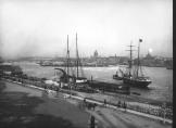
Bolshaya Neva
BOLSHAYA NEVA, the largest left branch of the the Neva river delta; a continuation of the Neva River below the Dvortsovaya Bridge. The Bolshaya Neva flows into the Neva Bay of the Gulf of Finland, in the area surrounded by Vasilievsky Island
|
|
|
|
|
hidden
|
Bolshaya Nevka
BOLSHAYA NEVKA, the extreme right branch of the Neva River delta, which flows off the main channel 500 metres below the Liteiny Bridge. It separates Vyborgskaya Side from Petrogradskaya Side and flows into the Neva Bay below the Spit of Elagin
|
|
|
|
|
hidden
|
Bumazhny Canal
Bumazhny Canal (Paper Canal) was dug between the Ekaterinhofka River and the Tarakanovka River for practical purposes in the second half of the 18th century. It bears its name from the Ekaterinhof Cotton Mill (today
|
|
|
|
|
hidden
|
Canals (entry)
CANALS are artificial waterways built from the time of St. Petersburg's founding to drain low and swamp lands and create convenient access to ship construction materials and other cargoes (Peter the Great’s wish to create "a second Venice" another
|
|
|
|
|
hidden
|
Canals of Galley Yard
CANALS OF THE GALLEY YARD were dug at the beginning of the 18th century in the western end of Admiralty Island, at the place of the Galley Yard. In 1711 and 1716
|
|
|
|
|
hidden
|
Catherine Square
CATHERINE SQUARE is situated in the centre of St. Petersburg on Nevsky Prospect. It is surrounded by the architecture ensemble of the Anichkov Palace, Alexandrinsky Theatre, and Russian National Library. The park was laid out in 1820-32 (architect K
|
|
|
|
|
hidden
|
Chernavka, river
CHERNAVKA, a river in the east of St. Petersburg, a tributary to the Okhta River. The length is about two kilometres; width in its lower course is up to 12 metres. The name was caused by the dark colour of the water
|
|
|
|
|
hidden
|
Chernaya Rechka River
CHERNAYA RECHKA, a river in the north-west of St. Petersburg. The name dates back to 1748. The river is a tributary of the Bolshaya Nevka River. Originally it sprang from Lake Dolgoe and flowed into the Bolshaya Nevka from the right
|
|
|
|
|
hidden
|
Chukhonka, river
CHUKHONKA, a river in the north-west of St. Petersburg, on Krestovsky Island. It was known from 1762 as the Chukhonskaya River, to assume the present-day name in the 19th century
|
|
|
|
|
hidden
|
Dachnaya, river
DACHNAYA, a river in the south-west of St. Petersburg, formerly a left tributary to the Krasnenkaya River. The river is drawn from the west of the village of Staropanovo
|
|
|
|
|
hidden
|
Dekabristov Garden
DEKABRISTOV GARDEN is situated on Dekabristov Island in the area of where it is thought that the graves of five executed Decembrists are located, hence the name. It is situated between Uralskaya Street, Nalichnaya Street and KIMa Avenue
|
|
|
|
|
hidden
|
Demidov Garden
DEMIDOV GARDEN is situated at Ofitserskaya (today Dekabristov) Street; between Pisareva Street and Moika River Embankment. In the early 18th century the lot belonged to Baron P.P
|
|
|
|
|
hidden
|
Deviatogo Yanvarya Children Park
DEVIATOGO YANVARYA CHILDREN PARK (20 Stachek Avenue) is located between Shvetsov Street, Marshal Govorov Street, Tikhomirskaya Street and Stachek Avenue. It consists of 10
|
|
|
|
|
hidden
|
Dolgoye Lake
DOLGOYE LAKE (Long Lake) is located in the northern St. Petersburg at the crossing of Olkhovskaya Street and Koroleva Avenue. Before the 18th century, it was named Pitkyyarvi ("long lake")
|
|
|
|
|
hidden
|
Dudergofka, river
DUDERGOFKA (Duderhof, known as Dudorovka in the 18th century), a river in the south-west of St. Petersburg. The name originates from Duderhof Heights. The river emerges from Lake Duderhof (Dudergofskoe)
|
|
|
|
|
hidden
|
Dudergofsky Canal
DUDERHOFSKY CANAL was built during the improvement of the Peterhof Highway and Southern Primorsky Park. It was named after the Duderhofka River (the Canal covers the river's mouth)
|
|
|
|
|
hidden
|
Duderhof Heights
DUDERHOF HEIGHTS a group of hills of glacial origin in the south of St. Petersburg eastwards from Krasnoe Selo and the Ligovo-Gatchina Railway. In the early 18th century they were known as the Duderhof Hills later Duderhof Heights (from Lappish
|
|
|
|
|
hidden
|
Duderhof Lake (Krasnoye Selo)
Duderhof Lake is located in the southern end of Krasnoye Selo (in Mozhaysky and Villosi Villages) at true altitude of 79.9 meters. It has a natural lowering among moraine hills in the centre of Izhora Heights (hence the name Duderhof Heights)
|
|
|
|
|
hidden
|
Dyuny, Forest Park
DYUNY, a Forest Park, spreading out along the coast of the Gulf of Finland forming a strip of approximately 13 by 3-4 km between the northern outskirts of Sertroretsk and Solnechnoe village
|
|
|
|
|
hidden
|
Earthern Dams
EARTHERN DAMS, zones within the territory of St. Petersburg with an artificially raised level. From the very first days of the city development bedding was used for the low spots to protect it from water, especially floods
|
|
|
|
|
hidden
|
Ekaterinhofka, river
EKATERINHOFKA, a river in the west of St. Petersburg. Originally called Chernaya Rechka, while its present name refers to the Ekaterinhof Palace. The river is a lateral channel of the Bolshaya Neva River: starting from the mouth of the latter and
|
|
|
|
|
hidden
|
Emelyanovka, river
EMELYANOVKA, a river to the south-west of St. Petersburg, in Avtovo. Its name has been known since 1772; it probably originates from the name of a landowner. The headwaters of the river used to be 1 kilometre westwards of the intersection of
|
|
|
|
|
hidden
|
English Park (Peterhof)
ENGLISH PARK is situated in the west part of Peterhof, in the lower course of Shinkarka River, to the north of Egerskaya Settlement and to the northwest of Lugovoy Park. Stary Petergof railway station is situated at its southwest outskirts
|
|
|
|
|
hidden
|
Galley Harbour
GALLEY HARBOUR is an engineering monument from the early 18th century. A rectangular pool located in the western part of Vasilievsky Island in the 18th - early 19th centuries served as a base for naval rowing vessels (galleys, hence the name)
|
|
|
|
|
hidden
|
Geological location
GEOLOGICAL LOCATION. St. Petersburg along with its outskirts is located on the convergence of two major tectonic structures: the southern Baltic Plate and the Northwest Russiаn Plate of the East European plain
|
|
|
|
|