Bibliographies
/
Лисовский В. Г. Ленинград: Р-ны новостроек. Л., 1983
hidden
|
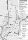
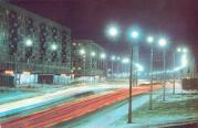
Basseinaya Street
BASSEINAYA STREET, translated as Pool Street, between Kubinskaya Street and Vitebsky Avenue. The name originated from a canal (pool) that was then in design. The street is roughly in line with the former Azovskaya Street, Erivanskaya Street
|
|
|
|
|
hidden
|
Bogatyrsky Avenue
BOGATYRSKY AVENUE, a part of the central ring road lying between Kolomyazhsky Avenue and Kamyshovaya Street. The name of Bogatyrsky Avenue and the neighbouring streets is associated with the history of national aviation - the first multi-engine
|
|
|
|
|
hidden
|
Ivanovskaya Street
IVANOVSKAYA STREET, running from Obukhovskoy Oborony Avenue to the Moskovskaya Line of the Oktyabrskaya Railroad, part of the Central Arched Line. Named in the 1890s after a house-owner
|
|
|
|
|
hidden
|
Kosmonavtov Avenue
KOSMONAVTOV AVENUE is located between Kuznetsovskaya Street and Svirskaya Street, running across the Alexandrovskaya Settlement and Srednyaya Rogatka. Laid out in the 1960s and named in honour of Soviet cosmonauts
|
|
|
|
|
hidden
|
Krasnogvardeysky District
KRASNOGVARDEYSKY DISTRICT is an administrative territorial unit of St. Petersburg. (Its territory administration is located at 52 Sredneokhtinsky Avenue). It was established in 1973. It was named in honour of the Petrograd Red Guards
|
|
|
|
|
hidden
|
Krasnoputilovskaya Street
KRASNOPUTILOVSKAYA STREET, running from Komsomolskaya Square to Pobedy Square, passing through the Avtovo area, the former Vologodskaya-Yamskaya Settlement, the Alexandrovskaya Settlement, and Srednaya Rogatka
|
|
|
|
|
hidden
|
Leninsky Avenue
LENINSKY AVENUE, running between Doblesti Street and Moskovskaya Square, part of the Central Circular Highway. It connects Yugo-Zapad and Ulyanka settlement, and Dachny and Moskovsky Avenues. The avenue, named in 1977 after V.I
|
|
|
|
|
hidden
|
Mass Residential Construction (entry)
MASS RESIDENTIAL CONSTRUCTION. Started from the middle of the 1920s with the erection of apartment blocks. The first ones were erected in 1925-27, on Traktornaya Street (in 1927, 140,000 sq. metres of apartment houses were introduced)
|
|
|
|
|
hidden
|
Muzhestva Square
MUZHESTVA SQUARE known as Murinskaya or Spasskaya Square before 1965, between Karbysheva Street, Politekhnicheskaya Street, Second Murinsky Avenue, Toreza Avenue, and Nepokorennykh Avenue
|
|
|
|
|
hidden
|
Novo-Izmailovsky Avenue
NOVOIZMAILOVSKY AVENUE between Blagodatnaya Street and Konstitutsii Square. It was laid close to the former Korpusnoe Highway in the same direction as one of the three radial roads - Voznesensky Avenue and Izmailovsky Avenue (hence the name
|
|
|
|
|
hidden
|
Slavy Avenue
SLAVY AVENUE, between Vitebskaya Railway Line and Moskovskaya Railway Line. It was named in 1964 in honour of the military victories and feats of labour of Leningrad citizens
|
|
|
|
|
hidden
|
Sverdlovskaya Embankment
SVERDLOVSKAYA EMBANKMENT (in 1887-1925 - Polyustrovskaya Embankment, after the area of Polyustrovo), on the right bank of the Neva River, between Arsenalnaya Street and Krasnogvardeiskaya Square. It was named after Y.M. Sverdlov
|
|
|
|
|
hidden
|
Svetlanovsky Avenue
SVETLANOVSKY AVENUE, between Svetlanovskaya Square and Suzdalsky Avenue. The avenue was built in the first half of the 20th century. In the 1910s, the lot between modern Toreza Avenue and Jacques Duclos Street was constructed and given the name
|
|
|
|
|
hidden
|
Toreza Avenue
TOREZA AVENUE, called Staro-Pargolovsky Avenue until 1964, from Muzhestva Square to the intersection of Engelsa Avenue and Severny Avenue. The avenue was laid in the 18th century and led towards Pargolovo (hence the original name)
|
|
|
|
|
hidden
|
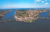
Vasilievsky Island
VASILIEVSKY ISLAND, the largest island in the estuary of the Neva 1,090 hectares in area. The island is washed by the Bolshaya Neva in the south and the Malaya Neva in the northeast
|
|
|
|
|
hidden
|
Zanevsky Avenue
ZANEVSKY AVENUE, located on the right bank of the Neva River, extends from Malookhtinsky Avenue to Soedinitelnaya Railway Line, running through Malaya Okhta and Yablonevka
|
|
|
|
|
|
hidden
|