|
|
Entries
/
Neva, river
Neva, river
Categories /
City Topography/Waterways and Currents/Rivers
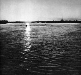
NEVA, a river in the north-west of Russia, around which the city of St. Petersburg is located at the river mouth. The river issues from the Shlisselburg Bay of Lake Ladoga and enters the Neva Bay of the Gulf of Finland. The name is thought to be derived from the Finnish name for Lake Ladoga, Nevo. The Neva is 74 kilometres long, with the drainage basin equal to 282,300 km2, including 56,400 km2 within the Finnish territory. The area of the proper basin of the river is approximately 5,000 km2. The basin stretches from the north to the south and is characterised by a damp climate, the presence of numerous lakes, complex drainage network and partial flow control by means of lakes and storage pools. The basin of the Neva River comprises of over 48,300 rivers and nearly 26,300 lakes. Within the limits of St. Petersburg, the Neva stretches for 29.5 kilometres. Its banks from Ust-Slavyanka in the east of the city up to the mouth of the river are faced with granite almost everywhere, and the embankments have more than 300 water landings. The head of the river is 5.1 metres higher than its mouth. The Neva starts with two channels, between which Oreshek Island (Orekhovy Island), topped with the Shlisselburg Fortress, is situated. The northern channel is the main navigable route, called the Koshkin route after the neighbouring village. The Bolshaya Neva River is sits in opposition to the Nevskie Gates of Morskoy Canal, situated by the entrance to Gutuevskaya Harbour (so-called Dipper of the Sea Port) is considered to be the mouth of the Neva. The width of the river ranges from 400 metres to 700 metres, reaching 1,200 metres at the mouth and reducing to nearly 200 metres above St. Petersburg, near Ivanovskie rapids. The average depth ranges from 6 to 8 metres, coming up to 10-12 metres in some places, with a maximum depth of approximately 24 metres (near Liteiny Bridge). The headwaters of the Neva flow in a swift current, with the stream velocity equalling 0.3 metres per second, approaching 4.3 metres after 2.8 kilometres from the river source. Further on, the current velocity falls to 0.1 metre per second, increasing to 0.9 metres per second in the area of Ivanovskie rapids near the mouth of the Tosna River (44 kilometres from the mouth), where the depth of the channel is about 2 metres, and reducing to 0.3-0.4 metres per second within the limits of St. Petersburg. The banks of the river above St. Petersburg have a clear-cut and steep profile, rising 6-11 metres above the channel of the river, though within the limits of St. Petersburg the height of the banks does not exceed 2.5 metres, with 26 different currents falling into the Neva River. The most important tributaries are: the Mga, the Tosna, the Okhta (all of them exceeding the Neva River in size), the Izhora, the Slavyanka, the Chernaya, the Chernaya Rechka and the Utka. The current of the Neva meanders slightly, although the river has three sharp bends: one near Ivanovskie rapids, the next one is beside the Nevsky Forest Park and Ust-Slavyanka (so-called Krivoe Koleno, the dog leg, literally, the curved knee) and the last one near Smolny below the mouth of the Okhta River. The Neva River is often divided into two sections, the Upper Neva, which flows from the head to Ivanovskie rapids and is 29 kilometres long, and the Lower Neva, flowing from the rapids to the mouth and is 45 kilometres. This conventional division is based not only on the form of the river-valley, but on its derivations as well. The Neva as we know it appeared 2,500-3,000 years ago as a result of erosive processes resulting in a contraction of the Tosna River, running towards Littorina Sea which existed on the site of the Baltic Sea and the Gulf of Finland, and of the Mga River, which ran into Lake Ladoga of that time, with a higher water-level than that of the present-day lake. As a result of the junction of the river-valleys, the water-level of Lake Ladoga partially lowered, and the Neva River acquired its modern guise. One of its characteristic features of the Neva is the absence of flood plains and river terraces. The pre-existing terraces of the Mga and the Tosna are situated outside the valley of the Neva; at present we can find only some remnants of them, which join the adjacent terraces of ancient Ladoga or ancient Baltics. The fluctuations of the level of Littorina Sea during the past 2,000-2,500 years led to the formation of the Neva delta, which is actually a pseudo-delta: its shape is reminescent of a delta, although the Neva delta was not formed by the accumulation of fluvial materials, as deltas are; the delta of the river was made up by cutting-in into pre-existing marine deposits and marine-lacustrine deposits. This is also the origin of the islands washed by the Neva delta: Vasilievsky Island, Dekabristov Island, Petrogradsky Island, Aptekarsky Island, Kamenny Island, Krestovsky Island, Petrovsky Island, Elagin Island and partly Admiralteysky Island, Gutuevsky Island and Kanonersky Island. In fact, only the accumulation sand at the mouth of the Neva branches, deposited at the point of their contact with the waters of the Neva Bay, can be regarded as pertaining to a delta. This original sand-bar represents a system of underwater sandbanks interrupted by navigation channels. Among the sandbanks of the Neva River the following should be distinguished: the Northern Lakhtinskaya Sandbank and Sobakina Sandbank, Krestovskaya Sandbank, Galernoy Kosy Sandbank, Zolotoy Ostrov, Belaya Sandbank, Kanonerskaya Sandbank and Southern Lakhtinskaya Sandbank. They comprise six navigable channels in between them, with some of the passes deepened artificially: Elaginsky Fairway, Petrovsky Fairway, Galerny Fairway, Korabelny Fairway, Grebnoy Fairway and Morskoy Canal navigation channels. The runoff of the Neva is regulated by Lake Ladoga. Since monitoring began in 1859, the lowest water content of the Neva was registered in 1900 with as little as 40.2 km3, whereas the highest volume occurred in 1924 with 116 km3. The flow rate varies from 4,750 m3 per second in the years of high-water level (1924) to 540 m3 per second, which occurred in the winter of 1973, averaging 2,520 m3 per second. The fluctuations of the level of the upper reaches of the river depend on the state of Lake Ladoga. In times when the water level of the lake drops, the river route from the lake to the Neva becomes difficult. In winter, the upper river experiences ice jams and ice gorges from time to time which causes flooding upstream, while downstream there is a significant decrease in water-levels and flow rates. In the lower reaches of the Neva, the fluctuations of the water-level depend on weather in the Baltics and the Gulf of Finland. All the recorded floods extended along the Neva to the mouth of the Okhta River and the head of Obvodny Canal, inundating mainly the lowland part of St. Petersburg, below Liteyny Bridge. The average water temperature in the Neva measures from 17? C to 20? C at the height of summer. The bathing season lasts for about a month and a half. The whole length of the Neva usually freezes up in December, with ice breaking up in April. The thickness of ice ranges from 0.3-0.4 metres within the limits of the city to 0.5-0.6 metres outside St. Petersburg. The river has fresh, calcium hydrocarbonate water, with average mineralization rate of 61.3 milligrammes per litre and average turbidity equalling 7 milligrammes per litre. Within St. Petersburg, the Neva is heavily polluted with industrial waste. The water of the river is used for water-supply and technical purpose. The fishery on the Neva is quite developed. The navigable river is one of the chief waterways of the Volga-Baltic and the White Sea-Baltic waterway systems. Above St. Petersburg, the river accommodates on its banks the town of Otradnoe, the town of Kirovsk, Shlisselburg and numerous inhabited localities. Within the limits of St. Petersburg, the river is spanned by eight bridges: Lieutenant Schmidt Bridge, Dvortsovy Bridge (across the Bolshaya Neva), Troitsky Bridge, Liteiny Bridge, Bolsheokhtinsky Bridge, Alexandra Nevskogo Bridge, Volodarsky Bridge and Finlyandsky Railway Bridge (see the articles on these bridges). Outside St. Petersburg, a highway bridge was built along the Kola route near the village of Maryino, four kilometres westward of Shlisselburg. A main oil pipeline was built under the river at the same place. In the area of the village of Pavlovo-na-Neve the river is crossed by a railway bridge. References: Нежиховский Р. А. Река Нева. 3-е изд. Л., 1973; Его же. Река Нева и Невская губа. Л., 1981; Ильина Л. Л., Родионов В. З. Воды и веси: (Экол.-ист. очерк). СПб., 1997. С. 55-66. Y. P. Seliverstov.
Addresses
Neva River/Saint Petersburg, city
Bibliographies
Ильина Л.Л., Родионова В.З. Воды и веси: (Экол.-ист. очерк). СПб., 1997
Нежиховский Р. А. Река Нева. 3-е изд. Л., 1973
Нежиховский Р. А. Река Нева и Невская губа. Л., 1981
|