Maps and Atlases (entry)
Categories /
Architecture/Urban Planning/Plans
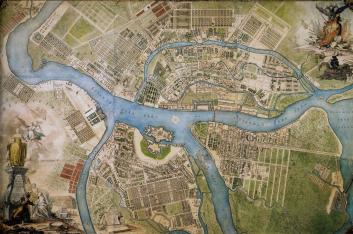
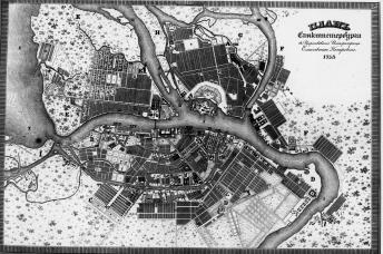
MAPS AND ATLASES. The first known Russian hand-written picture of the Neva River mouth and the territory adjoining the Gulf of Finland dates back to the late 17th century. The first cartographic plans of this region (the mouth of the Neva and Nyenschantz) date to the early 18th century. In 1703, hand-written maps with St. Peter and Paul Fortress indicated appeared. Cartographic plans of the early 18th century defensive constructions on the islands in the mouth of the Neva river have survived. The first St. Petersburg planning maps were created by D. Trezzini (1716) and J.B. Le Blond (1717). In 1738, under the guidance of Life Guards Captain Lieutenant J. von Siegheim St. Petersburg map with the police-administrative division of the city was drawn. On its base The Plan of Imperial Capital City of St. Petersburg, worked out by the Commission for St. Petersburg Construction (published in 1741 in the Engraving Album The Chambers of St. Petersburg Imperial Academy of Sciences, Library and Kunstkammer) was compiled. On their basis under the guidance of Adjunct I.F. Truscot The Plan of the Capital City of St. Petersburg with the most famous avenues of it depicted containing nine map-sheets and sixteen appendix pages of St. Petersburg panoramas was prepared in 1749 and published in 1753. Produced under the guidance of M.I. Makhaev, assisted by a pinhole camera, the plan contains "Description of the sides, islands, rivers, canals, monastery, cathedrals, parishes and other churches, houses, public constructions, etc." In 1764-1773, the mathematician P. de Saint-Hilaire, the engraver M. I. Sokolov and architect's assistant Gorikhvostov compiled an axonometric plan, demonstrating St. Petersburg development during the first half of the 18th century. In 1797, Atlas of the City of St. Petersburg, Compiled by Staff and Chief-officers of His Majesty’s Retinue Quartermaster’s Unit and General-Quartermaster Baron Arakcheev (so called Arakcheev's Plan) was published. In 1806, the Committee for City Duties under the guidance of Count A.S. Stroganov compiled and published the atlas of St. Petersburg that contained a general plan of the city and plans of 55 of its neighbourhoods (so called Stroganov's Plan). The first plan, done on the basis of a geodetic survey was The Detailed Plan of the Capital City of St. Petersburg..., compiled by Major General F.F. Schubert and engraved in 1828 in the Military Topographic Depot (scale: 1:4,200, 24 sheets, format 80x50 cm and 50x50 cm). In 1949, the large-scale Atlas of 13 Parts of St. Petersburg... (392 sheets, format 26x19 cm, alphabetical index - 309 p.) compiled by N.I. Tsylov was published. In the 1830s-50s small atlases of retrospective cartographic images of St. Petersburg were issued. Following the flood of 1824, The Plan of St. Petersburg Flood of 7 November 1824 with the flood height survey came out. In 1893, A. A. Tillo's map Project of St. Petersburg Flood Protection (scale: 1:29300) was issued. The best pre-Revolutionary St. Petersburg relief map is considered to be The Contour Plan of St. Petersburg, executed to the levelling of 1872 and 1900. (Edition of the Cartographic Establishment of A. A. Ilyin, scale: 1:4200, 22 pages). In the second part of the 19th - early 20th centuries, numerous subject-matter plans of St. Petersburg appeared in print. After October 1917, plans and schemes reflecting city development, zoning, urban transport routes, etc. were issued. The leading cartographic publishing house of the 1920-30s was the First State Cartographic Establishment (later State Cartography - former Ilyin Cartographic Establishment). In 1932, The New Plan of Leningrad According to Air Imagery (scale: 1:22000) was published. In 1950s, the issue of Leningrad plans and maps ceased, only city layouts without scale, with the limitation of contents fullness and geometric similarity (publisher - The Main Geodesy and Cartography Department of USSR Council of Ministers) were issued, several schemes were published by Lenizdat and Intourist. In 1957, Historic-Geographic Atlas, prepared by specialists and scientists of Leningrad State University, came out. It reproduced 28 city maps of the 18 - early 19th centuries. In 1977, 1981 and 1989 historical-geographic atlas Leningrad with over 100 schemes was published. In the 1990s Orbita Publishing House issued a number of maps and schemes, based on accurate topographic geodesic and cartographic information.
References: Аркин Д. Е. Перспективный план Петербурга 1764-1773 гг.: (План Сент-Илера - Горихвостова - Соколова) // Архитектурное наследство. Л.; М., 1955. [Сб.] 7. С. 13-38; Луппов С. П. Планы Петербурга первых лет существования города: (по фондам отд. рукоп. и редкой кн. БАН СССР) // Тр. БАН и ФБОН АН СССР. 1959. Т. 4. С. 323-332; Виды Петербурга и его окрестностей середины XVIII века: Грав. по рис. М. Махаева. Л., 1968; Нежиховский Р. А. Река Нева и Невская губа. Л., 1981.
O. A. Chekanova.
Persons
Gorikhvostov
Ilyin Alexey Afinogenovich
Le Blond Jean-Baptiste Alexander
Makhaev Mikhail Ivanovich
Saint-Hilaire Pierre
Schubert Fedor Fedorovich
Siegheim J. von
Sokolov M.I.
Stroganov Alexander Sergeevich, Count
Tillo Alexey Andreevich
Trezzini Domenico
Truscot I.F.
Tsylov Nikolay Ivanovich
Bibliographies
Луппов С. П. Планы Петербурга первых лет существования города: (по фондам отд. рукоп. и редкой кн. БАН СССР) // Труды БАН и ФБОН АН СССР. 1959. Т. 4
Аркин Д. Е. Перспективный план Петербурга 1764-1773 гг.: (План Сент-Илера - Горихвостова - Соколова) // Архитектурное наследство. Л.; М., 1955
Нежиховский Р. А. Река Нева и Невская губа. Л., 1981
Виды Петербурга и его окрестностей середины XVIII века: Грав. по рис. М. Махаева. Л., 1968
The subject Index
St. Peter and Paul fortress
St. Peter and Paul fortress
Commission for St. Petersburg Construction
Chronograph
1738


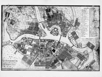

. 1828. A fragment of the central part of the plan.")


