|
|
|
Entries
/
St. Petersburg Dam
St. Petersburg Dam
Categories /
City Services/Housing and Communal Services
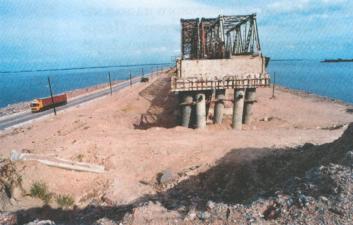
ST. PETERSBURG DAM is a hydro-technical complex, built in the mouth of the Neva where it enters the Gulf of Finland to prevent floods. First dam projects for St. Petersburg date back to the 18th century: The St. Petersburg urban planning projects by architects D. Trezzini and J.B. Vallin de la Mothe provided for soil bedding of Vasilievsky Island and Gorodskoy Island territory up to the 3.2 metre mark above the zero water level. In 1727, C.A. Minich devised the first flood protection project for St. Petersburg, suggesting to "protect the city and every single island with dams and considerable raising and fortifying of river banks". After the flood of 7 November 1824 the government called for an international tender for the best flood protection project for St. Petersburg. The project by P.P. Bazaine, which suggested to hedge the Neva bay (with the Neva delta) from the waters of the Gulf of Finland by a stone dam (from the Lisy Nos (Fox Nose) via the island of Kotlin to Oranienbaum) served as a foundation for a number of barrier construction projects of the late 19th century (by N.N. Mossakovsky, Y.K. Ganneman, V.F. Prussak), as well as for the draft project of 1933, developed by the Leningrad Research Institute of Communal and Housing Facilities and Construction under the leadership of professor S.A. Sovetov, and the present-day dam project, developed in 1967-78 in the Leningrad Division of the Hydroproject Research Institute (Lenhydroproject) during the implementation of the General Development Plan of Leningrad in 1966 (chief project engineer S.S. Agalakov, since 1981 - S.N. Kuraev). A total of 52 institutes and organizations of Leningrad and other cities contributed to the project, and some 20 organizations contributed to the ecological feasibility report. The project's architectural design was carried out in the Leningrad Research Project Institute under supervision of architect A.V. Zhuk. The building of the dam began in the fall of 1979 under the supervision of Lengidroenergospetsstroi Research Institute. The dam has two navigation passes and six culverts, 11 earth-and-rock-fill dams, and maintenance and service building. The dam runs from Gorskaya station at the north coast of the Gulf of Finland via the Island Kotlin to Bronka Station on the south coast. Its total length is 25.4 km, of which 22 km run over the waters of the bay. The dam’s height (with the sea wall) is 8 m. Water treatment facilities were supposed to be built in St. Petersburg before the dam project began. The project led to a heated debate as to its impact on the environment in the mouth of the Neva. In 1990, an international commission ascertained that the ecological situation in the mouth of the Neva and the Gulf of Finland was not significantly affected by the dam in comparison to other anthropogenic influences (such as sewage, navigation, dredging, recreation, etc.). In the late 1980s construction of the dam was suspended due to the lack of funding. In 2002 the construction project resumed. Reference: Глебов И. А. О строительстве в Ленинграде защитной дамбы от наводнений и очистных сооружений для сточных вод // Вестн. АН СССР. 1988. № 6. С. 9-18; Григорьев Ю. А. Комплекс защиты Санкт-Петербурга от наводнений // Гидротехн. стр-во. 1997. № 9. С. 13-17. I. A. Bogdanov.
Persons
Agalakov S.S.
Bazen Peter Petrovich
Hanneman Ya.K.
Kuraev S.N.
Minich Christoph Antonovich (Burghard Christoph), Count
Mossakovsky N.N.
Prussak Vladimir Fedorovich
Sovetov S.A.
Trezzini Domenico
Vallin de la Mothe Jean Baptiste Michel
Zhuk Alexander Vladimirovich
Bibliographies
Глебов И. А. О строительстве в Ленинграде защитной дамбы от наводнений и очистных сооружений для сточных вод // Вестн. АН СССР, 1988
Григорьев Ю. А. Комплекс защиты Санкт-Петербурга от наводнений // Гидротехн. стр-во, 1997
Chronograph
1979
|