Addresses
/
Stachek Ave/Saint Petersburg, city
hidden
|
Avtovo
AVTOVO, an area in the southwest part of St. Petersburg, bordered by the Krasnenkaya River on the south and Komsomolskaya Square on the north. The name origin traces back to the Finnish village of Autovo (Auktovo)
|
|
|
|
|
hidden
|
Dachnoe
DACHNOE, an area in the south-west part of St. Petersburg, between Krasnenkaya River, Baltiiskaya Railway Line, Stachek Avenue and Alexandrino Forest Park. In the north, it borders Avtovo, in the south-west Ulyanka
|
|
|
|
|
hidden
|
Grilles (entry)
GRILLES. St. Petersburg boasts a number of unique metal grilles, created in the course of three centuries. Wrought grilles of bars with (sometimes gilded) decorative figures made from flat iron bars (the grille of the Ekaterininsky (Catherine)
|
|
|
|
|
hidden
|
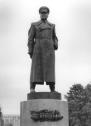
Kamensky V.A. (1907-1975), architect.
KAMENSKY Valentin Alexandrovich (1907-1975), architect, national architect of the USSR (1970). In 1931-39, he taught at Leningrad College of Civil Engineers following his graduation from the institute; from 1941
|
|
|
|
|
hidden
|
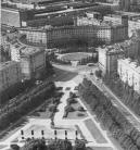
Kirovskaya Square
KIROVSKAYA SQUARE, located at the intersection of Stachek Avenue and Shvetsova Street. Created in the 1930s as an administrative centre for the Moskovsko-Narvsky (since 1934, Kirovsky) District, according to a plan design by architect L.A
|
|
|
|
|
hidden
|
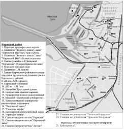
Kirovsky District
KIROVSKY DISTRICT is an administrative territorial unit of St. Petersburg. (Its territory administration is located at 18 Stachek Avenue). The district was named in honour of Sergey Kirov in 1934. Its present-day borders were established in 1973
|
|
|
|
|
hidden
|
Komsomolskaya Square
KOMSOMOLSKAYA SQUARE, at the intersection of Stachek Avenue and Krasnoputilovskaya Street. Constructed in the 1950s in the course of the development of the Avtovo District, according to a plan designed by architect A.A. Ol in the 1930s
|
|
|
|
|
hidden
|
Krasnenkaya, river
KRASNENKAYA, a river in the south-west of St. Petersburg, flowing through Avtovo District and Yugo-Zapad District. The name of the river dates back to 1773, when it was known as Krasnaya Rechka
|
|
|
|
|
hidden
|
Narvskaya Zastava
NARVSKAYA ZASTAVA, the historical name of the northern part of Kirovsky District. It descends to an outpost on the post road to Narva and Reval (today Tallin), that was located on the place of present-day Stachek Square
|
|
|
|
|
hidden
|
Natural sights
NATURAL SIGHTS, natural formations, typical of certain processes and phenomena and as a rule specific within surrounding scenery; they can be divided into geological, geomorphological, botanic, hydrological sights etc
|
|
|
|
|
hidden
|
Petergofskaya Road
PETERGOFSKAYA ROAD (Petergofskaya Pershpektiva), name of Narvskaya Road between St. Petersburg and Peterhof in the 18th century. The road ran along the southern coast of the Gulf of Finland in place of the present-day Staro-Petergofsky Avenue
|
|
|
|
|
hidden
|
Relief
RELIEF. Despite having a general plain character, its flatness and large built up areas, the relief of St. Petersburg is diverse and full of contrasts. The highest peaks in the southwest of the city reach 176 meters
|
|
|
|
|
hidden
|
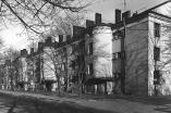
Residential Blocks (entry)
RESIDENTIAL BLOCKS, a site development system typical for new city districts built in the 1920-30s. Due to an acute demand for accommodations in the mid-1920s, individual home building was replaced by residential blocks - a new type of city
|
|
|
|
|
hidden
|
South-West
South-West, the region of large-scale residential development, a part of Krasnoselsky District territory to the north of Petergofskoe Freeway and to the west from Stachek Avenue
|
|
|
|
|
hidden
|
Stachek Avenue
STACHEK AVENUE, called Petergofskoe Highway until 1923, then known as Stachek Street until 1940, between Stachek Square and the place where Marshala Zhukova Avenue and Petergofskoe Freeway intersect
|
|
|
|
|
hidden
|
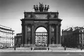
Stachek Square
STACHEK SQUARE, known as Narvskaya Square until 1923, at the intersection of Stachek Avenue, Narvsky Avenue and Staro-Petergofsky Avenue. The square assumed the present-day name in commemoration of the strike movement (the name of the square
|
|
|
|
|
hidden
|
Steam Railway
STEAM RAILWAY (horse-drawn railway, steam-driven tram). Urban transport, a type of horse-drawn tram. Steam traction was introduced in 1882 along the Nevskaya Horse-Drawn Railway on the route from Znamenskaya Square (today Vosstania Square) to
|
|
|
|
|
hidden
|
Traktornaya Street
TRAKTORNAYA STREET, from Stachek Avenue to Sivkov Lane. The street was laid on the place of Krylova Lane and named so in 1926 in commemoration of the output of the first tractors at the Krasny Putilovets plant (present-day Kirov Plant)
|
|
|
|
|
hidden
|
Tramway
TRAMWAY (borrowed into Russian as the word derived from English tram (carriage) and way), a means of city rail transport. Three kinds of tramways are known: horse-drawn (see Horse-tram)
|
|
|
|
|
hidden
|
Zastavy (Outposts) (entry)
ZASTAVY (OUTPOSTS), checkpoints, established in the early 18th century on the main roads at the entrance to St. Petersburg to check goods, luggage and to register people, leaving or entering the city
|
|
|
|
|
|
hidden
|
|
hidden
|
|
hidden
|
|
hidden
|