|
|
|
Addresses
/
Moskovskoe Freeway/Saint Petersburg, city
hidden
|
Hero-city Park
HERO-CITY PARK is situated in the south of St. Petersburg, between Pulkovskoe Highway, Moscovskoe Highway and Dunaysky Avenue. It was laid out on the site of orchards and vegetable gardens in 1972-80 and had an area of 25 hectares
|
|
|
|
|
hidden
|
Monasteries (entry)
MONASTERIES, there were four monasteries in Petrograd (two women’s convents and two men’s monasteries) by 1917, and 42 metochions, which functioned according to monastery regulations
|
|
|
|
|
hidden
|
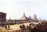
Moskovskoe Freeway
MOSKOVSKOE FREEWAY, between Pobedy Square and line of the Circular Railway, continues Moskovsky Avenue. It appeared in the first quarter of the 18th century as the road to Sarskaya Myza (Tsarskoe Selo) and further on to Novgorod and Moscow (in the
|
|
|
|
|
hidden
|
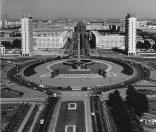
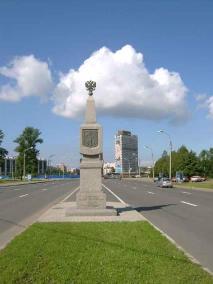
Pobedy Square
POBEDY SQUARE located at the intersection of Moskovsky Avenue, Moskovskoe Freeway, Pulkovskoe Freeway and Krasnoputilovskaya Street, and Ordzhonikidze Street. Until 1962
|
|
|
|
|
hidden
|
Srednyaya Rogatka
SREDNYAYA ROGATKA, the historical name of the area where Pulkovskoe Freeway and Moskovskoe Freeway intersect. In the 18th-19th centuries, an outpost was located there and the road was blocked with rogatka (turnpike) at night (hence the name)
|
|
|
|
|
hidden
|
Yury Gagarin Avenue
YURY GAGARIN AVENUE, between Blagodatnaya Street and Moskovskoe Freeway. From the 1910s to 1961 the avenue bore the name Narymsky Avenue, after the village of Narym in Tomskaya Region
|
|
|
|
|
|
hidden
|
|
hidden
|
|