Persons
/
Pushkin Alexander Sergeevich
hidden
|
Solnechnoe, settlement
SOLNECHNOE (until 1948 Ollila), formerly a settlement, since 1998, a municipal unit of the Kurortny District, a resort area on the Gulf of Finland's northern coast; also a railway station. As of 2001, the population totalled 1,000 inhabitants
|
|
|
|
|
hidden
|
Sosnovaya Polyana
SOSNOVAYA POLYANA (Pine Glade), a park to the south-east of St. Petersburg between Veteranov Avenue and Narodnogo Opolchenia Avenue. From the west, it is confined by the Sosnovka River
|
|
|
|
|
hidden
|
Sosnovka (Nevsky District)
SOSNOVKA, the historical name of the area to the south-east of St. Petersburg, between the Neva River, Narodnaya Street and Bolshevikov Avenue. It was named after the manor of A.I
|
|
|
|
|
hidden
|
Sosnovka (Vyborgsky District)
SOSNOVKA, a historical district in the north of St. Petersburg, in the north-east it joins Sosnovka park, in the south-west it is confined with Nauki Avenue, Gzhatskaya Street, Favorskogo Street, Politehnicheskaya Street and Toreza Avenue
|
|
|
|
|
hidden
|
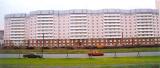
South-West
South-West, the region of large-scale residential development, a part of Krasnoselsky District territory to the north of Petergofskoe Freeway and to the west from Stachek Avenue
|
|
|
|
|
hidden
|
Spassky Island
SPASSKY ISLAND, translated as Saviour Island, situated in the centre of St. Petersburg between the Fontanka River, Moika River, Griboedova Canal, and Kryukov Canal. It is over 230 hectares in area
|
|
|
|
|
hidden
|
Srednyaya Rogatka
SREDNYAYA ROGATKA, the historical name of the area where Pulkovskoe Freeway and Moskovskoe Freeway intersect. In the 18th-19th centuries, an outpost was located there and the road was blocked with rogatka (turnpike) at night (hence the name)
|
|
|
|
|
hidden
|
Staraya Derevnya
STARAYA DEREVNYA, a historical district in the north-west of St. Petersburg, on the right bank of the Bolshaya Nevka River (opposite Elagin Island), to the west of Novaya Derevnya. In the 18th century, chancellor A. P
|
|
|
|
|
hidden
|
Staropanovo
STAROPANOVO, the former village, located to the south of Ligovo Railway Station, along Tallinskoe Freeway (buildings 60-190). Appeared in the early 19th century (was also-called Maloe Ligovo and Ekaterininskaya)
|
|
|
|
|
hidden
|
Steklyanny Settlement
STEKLYANNY SETTLEMENT (Glass Settlement), an area on the left bank of the Neva River, on the territory of Nevskaya Zastava, between Obvodny Canal in the north and Smolenskoe village in the south. In the 1770s, the territory belonged to G.A
|
|
|
|
|
hidden
|
Strelna
STRELNA, formerly a settlement, a municipal unit within the Petrodvortsovy District since 1997; 19 kilometers southwest of Saint Petersburg, on the southern coast of the Gulf of Finland, where it meets the Strelka River
|
|
|
|
|
hidden
|
Summer Residences (entry)
SUMMER RESIDENCES, places for recreation during the summer for St. Petersburg residents. Before the construction of railways, well off St. Petersburg residents spent their holidays in owned or rented summerhouses close to the city
|
|
|
|
|
hidden
|
Tarkhovka, locality
TARKHOVKA, a locality south of Sestroretsk, between the Primorskoe Highway and Lake Sestroretsky Razliv. It borders Razliv on the north, and the Alexandrovskaya station on the south; also the name of a train station along the Saint Petersburg -
|
|
|
|
|
hidden
|
Territory of the City (entry)
TERRITORY OF THE CITY. In the 16th century, settlements subordinated to Spassky, Gorodensky, Nikolsky, Izhorsky and Vozdvizhensky Korboselsky churchyards of Great Novgorod existed on the territory of the present-day St. Petersburg
|
|
|
|
|
hidden
|
Torfyanoe
TORFYANOE, an area to the north of St. Petersburg, between Pargolovo in the west and Parnas industrial zone in the east. The name comes from a village of the same name that appeared in the late 1920s owing to peat digging developed in this region
|
|
|
|
|
hidden
|
Toriki
TORIKI, an area to the south-west of St. Petersburg, to the west of Gorelovo railway station, along Anninskoe Freeway. In the early 18th century, Konstantinovka village was located on this site
|
|
|
|
|
hidden
|
Troitskoe Field
TROITSKOE FIELD, an area to the south-east of St. Petersburg, on the left bank of the Neva River, between Obukhovskoy Oborony Avenue, Zaporozhskaya Street, Gribakinykh Street and Babushkina Street. A part of Alexandrovskoe
|
|
|
|
|
hidden
|
Troitsky Island
TROITSKY ISLAND (Trinity Island) used to bear the name Petrogradsky Island, along with the name of Gorodskoy Island in the first third of the 18th century. After, it was renamed after the Holy Trinity and St. Peter's Cathedral.
Е. А
|
|
|
|
|
hidden
|
Tsentralny (Central) District
TSENTRALNY (CENTRAL) DISTRICT, an administrative-territorial entity within St. Petersburg, with the territorial administration situated at 176 Nevsky Prospect. The district was set up in 1994, when Smolninsky District
|
|
|
|
|
hidden
|
Turukhtannye Islands
TURUKHTANNYE ISLANDS, an area to the south-west of St. Petersburg, in the zone of the coal harbour of the seaport. The name comes from waterlogged islands that existed on this site before the 1930s, but merged with the mainland
|
|
|
|
|
hidden
|
Tyarlevo, village
TYARLEVO, formerly a village, from 1998 a municipal division in Pavlovsk administrative district located at the banks of the Tyarlevsky Brook and the Slavyanka River, and adjacent to Pavlovsky Park in the south
|
|
|
|
|
hidden
|
Udelnaya
UDELNAYA, an area in the north part of St. Petersburg; in the north, it adjoins Ozerki, in the east - Sosnovka forest park, in the east - Kolomyagi, in the south-west - Udelny Park
|
|
|
|
|
hidden
|
Ulyanka
ULYANKA, an area to the south-west of St. Petersburg; in the north-east, it borders on Dachnoe (divided from it with Alexandrino forest park); in the west, it is confined with Marshal Zhukov Avenue, in the south - with Narodnogo Opolcheniya Avenue
|
|
|
|
|
hidden
|
Uritsk
URITSK, a former separate town within the Leningrad Region. Founded in 1925, and named after М. S. Uritsky, the town stretched along the territory of the present-day Krasnoselsky District, west of Ligovo
|
|
|
|
|
hidden
|
Ushkovo, village
USHKOVO (until 1948 Tyurisevya), formerly a village, since 1998 - a municipal unit of Kurortny District, 49 km to the north-west of St. Petersburg, in the resort area on the north coast of the Gulf of Finland; a railway station
|
|
|
|
|
hidden
|
Ust-Slavyanka
UST-SLAVYANKA, an area to the south-east of Rybatskoe, on the right bank of the Slavyanka River, where it flows into the Neva River. The name appeared before the foundation of St. Petersburg
|
|
|
|
|
hidden
|
Utkina Zavod
UTKINA ZAVOD, a locality in southeast of Saint Petersburg, on the Neva River's right bank, just above the Utka River Estuary, along the Oktyabrskaya Embankment
|
|
|
|
|
hidden
|
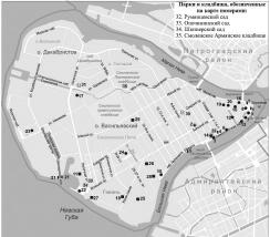
Vasileostrovsky District
VASILEOSTROVSKY DISTRICT is an administrative territorial unit of St. Petersburg. (Its territory administration is located at 55 Bolshoy Avenue of Vasilievsky Island) Its present-day borders were formed in 1917 (the western part was a separate
|
|
|
|
|
hidden
|
Vesely Poselok
VESELY POSELOK, an area in the south-east of St. Petersburg, on the right bank of the Neva River, between Dybenko Street, Bolshevikov Avenue and Novoselov Street
|
|
|
|
|
hidden
|
Volkova Village
VOLKOVA VILLAGE, an area to the south of Obvodny Canal, between Moscow Line and Vitebsk Line of Oktyabrskaya Railway, on the banks of the Volkovka River. Since the early 16th century, there was a Novgorod settlement
|
|
|
|
|