Authors
/
hidden
|
Nevsky District
NEVSKY DISTRICT, an administrative and territorial unit of St. Petersburg, with its administration located at 163 Obukhovskoy Oborony Avenue. Formed in 1917, it was called Volodarsky District in 1920-49
|
|
|
|
|
hidden
|
New Peterhof
NEW PETERHOF, part of the town of Petrodvorets, west of the Angliisky Park, also the name of a railway station along the Saint Petersburg - Lomonosov line. The Petrodvorets Watch Plant and the Popov Higher Navy School of Radioelectronics are located
|
|
|
|
|
hidden
|
Novaya Derevnya
NOVAYA DEREVNYA, a historical district in the north-west of St. Petersburg, on the right bank of the Bolshaya Nevka River, in the west it borders on Staraya Derevnya, in the east it is confined by the Chernaya Rechka River
|
|
|
|
|
hidden
|
Novo-Admiralteysky Island
NOVO-ADMIRALTEYSKY ISLAND, translated as New Admiralty Island, situated between the Bolshaya Neva River, Moika River, and Novo-Admiralteysky Canal. It was a part of Usadishche Island until the early 18th century
|
|
|
|
|
hidden
|
Novo-Kovalevo
NOVO-KOVALEVO, a locality in the far east of St. Petersburg southwards from Post Kovalevo Railway Station of Vsevolozhskoe direction. The name is derived from a former settlement which in 1973 was incorporated within Krasnogvardeysky District of
|
|
|
|
|
hidden
|
Novy Port
NOVY PORT (New Port), a locality in the northern part of Gutuevsky Island. The name appeared in the late 19th century after the relocation of the Morskoy Trade Port
|
|
|
|
|
hidden
|
Obukhovo
OBUKHOVO, a landmark in southwest of Saint Petersburg, between Sofiyskaya Street, Alexandrovskoy Fermy Avenue, the Moskovskaya railway line and the Yuzhnoe railway semi-circle
|
|
|
|
|
hidden
|
Old Peterhof
OLD PETERHOF, the name of a part of Petrodvorets west of the Angliisky Park; also a railway station along the Saint Petersburg-Lomonosov line. In the 1970-80s, an academic training facility and one of Saint Petersburg State University's campuses
|
|
|
|
|
hidden
|
Osinovaya Roshcha (Aspen Grove)
OSINOVAYA ROSHCHA (Aspen Grove), a former settlement north of Pargolovo at the junction of the Vyborgskoe and Priozerskoe Highways. First records of Osinovaya Roshcha trace back to the late18th century
|
|
|
|
|
hidden
|
Ostrova, area
OSTROVA (Islands), general unofficial name of Elagin Island, Krestovsky Island and Kamenny Island (see articles), that was common in the 19th - early 20th centuries. In 1934-92, these islands were renamed Kirovskie (after S.M. Kirov)
|
|
|
|
|
hidden
|
Ozerki, locality
OZERKI, a locality in the northern part of Saint Petersburg, neighbouring Shuvalovo on the north, the Novo-Orlovsky forest park on the northwest, the Udelnaya metro station on the south, and Kolomyagi on the southwest
|
|
|
|
|
hidden
|
Pargolovo
PARGOLOVO, a former settlement; since 1997, a municipal unit along the Vyborgskoe Highway, in the Vyborgsлy District of Saint Petersburg; also, a train station. As of 2002, the population count was approximately 4,000 people
|
|
|
|
|
hidden
|
Parnas
PARNAS, an industrial and warehouse area to the north of Suzdalsky Avenue and junction railway line Ruchyi - Pargolovo. The overbridge on Kultury Avenue connects it with residential districts of St. Petersburg
|
|
|
|
|
hidden
|
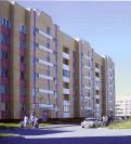
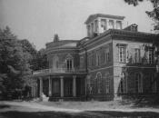
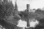
Pavlovsk, town
PAVLOVSK, a town (from 1796), municipal unit, and the centre of the Pavlovsky District on the Slavyanka River. Known as Slutsk in 1918-44. As of 2002, the population count was approximately 16,000 inhabitants
|
|
|
|
|
hidden
|
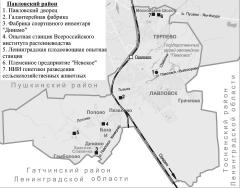
Pavlovsky District
PAVLOVSKY DISTRICT, an administrative and territorial unit of St. Petersburg, with its administration located in the town of Pushkin, at 24 Oktyabrsky Boulevard. It owes its name to the town of Pavlovsk at the district's centre
|
|
|
|
|
hidden
|
Peski
PESKI (sands), the historical name of the area in the centre of St. Petersburg, between the Neva River, Nevsky Prospect and Ligovsky Avenue, on both sides of Suvorovsky Avenue. The name is caused by the nature of the ground
|
|
|
|
|
hidden
|
Pesochny, settlement
PESOCHNY, a former settlement, since 1998, a municipal unit within the Kurortny District of Saint Petersburg; 23 kilometres northwest of the city centre; on the Chernaya River, 7 kilometres away from its inflow into Lake Sestroretsky Razliv
|
|
|
|
|
hidden
|
Petro-Slavyanka
PETRO-SLAVYANKA, a municipal unit within the Kolpinsky District, on the Slavyanka River, at the Kuzminka River inflow; also a train station along the Saint Petersburg - Moscow line. As of 2001, the population totalled 1,200 people
|
|
|
|
|
hidden
|
Petrodvortsovy District
PETRODVORTSOVY DISTRICT, an administrative-territorial entity within St. Petersburg, with the territorial administration located at 7 Kalininskaya Street, Petrodvorets. The district is named after the town of Petrodvorets, the district centre
|
|
|
|
|
hidden
|
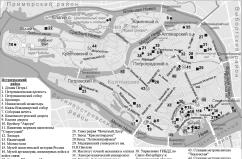
Petrogradskaya Side
PETROGRADSKAYA SIDE (in the 18th century - Gorodskaya Side, until 1914 - Peterburgskaya Side), the joint name of the territory that includes the following islands: Petrogradsky, Aptekarsky, Petrovsky and Zayachy
|
|
|
|
|
hidden
|
Petrogradsky District
PETROGRADSKY DISTRICT, an administrative and territorial unit of St. Petersburg, with its administration located at 19 Bolshaya Monetnaya Street. The district was formed in 1917, and in 1936 the Primorsky District was separated from its territory
|
|
|
|
|
hidden
|
Petrogradsky Island
PETROGRADSKY ISLAND situated between the Neva River, Kronverksky Strait, Malaya Neva River, Zhdanovka River, Malaya Nevka River, Karpovka River, and Bolshaya Nevka River. It is 635 hectares in area, 4.2 kilometres long, and 2.5 kilometres wide
|
|
|
|
|
hidden
|
Petrovsky Island
PETROVSKY ISLAND situated between the Malaya Neva River, Malaya Nevka River, and Zhdanovka River separating it from Petrogradsky Island. It is 120 hectares in area, three kilometres long, and 600 metres wide
|
|
|
|
|
hidden
|
Piskarevka
PISKAREVKA, an area to the north-east of St. Petersburg, to the north of Marshal Blucher Avenue and to the west of the railway junction line. It remained a neglected ground up to the beginning of the 19th century
|
|
|
|
|
hidden
|
Podzorny Island
PODZORNY ISLAND (Observation Island) is a defunct island that was situated at the mouth of the Fontanka River and was about two hectares in area. It was named after the Observation House situated on the island in the early 18th century
|
|
|
|
|
hidden
|
Pokrovsky Island
POKROVSKY ISLAND, translated as Intercession Island, area between the Fontanka River, Griboedova Canal, and Kryukov Canal. The area is about 40 hectares. The island was a part of Pervushin Island that also included Kolomensky Island, Kazansky Island
|
|
|
|
|
hidden
|
Police Units
POLICE UNITS, the main units of administrative and territorial division of St. Petersburg in the 18th - early 20th centuries. In 1737, at the suggestion of the Commission on Construction in St
|
|
|
|
|
hidden
|
Polyustrovo
POLYUSTROVO, an area on the right bank of the Neva River, confined with Marshal Blucher Avenue in the north and with Polyustrovsky Avenue and Revolyutsii Freeway in the south, while in the east it is bordered with the railway junction line
|
|
|
|
|
hidden
|
Pontonny, settlement
PONTONNY, a municipal unit within the Kolpinsky District since 1997, between the Neva River and the Bolshaya Izhorka River along the Petrozavodskoe Highway; also a railway station along the Saint Petersburg - Volkhovstroy Line
|
|
|
|
|
hidden
|
Porokhovye
POROKHOVYE, an area in the north-east of St. Petersburg, on the left bank of the Okhta River, between Rzhevka and Malaya Okhta. It encompasses territories of Malinovka and Zhernovka
|
|
|
|
|