|
|
|
Authors
/
hidden
|
Volny Island
VOLNY ISLAND, name of two now defunct islands. 1) Volny Island at the mouth of the Malaya Neva River where the coasts watch post was situated until the early 20th century. It was linked to Dekabristov Island after deposition of soil in 1960s
|
|
|
|
|
hidden
|
Volodarsky, village
VOLODARSKY VILLAGE (until 1918 - Alexandrovsky village), an area 18 km south-west from the centre of St. Petersburg. Volkhonskoe Freeway joins it with Strelna and Pushkin, while Krasnoselskoe Freeway connects it with Krasnoe Selo
|
|
|
|
|
hidden
|
Volynkina Village
VOLYNKINA, formerly a village, situated by the Ekateringofka River in the area of the intersection of present-day Kalinina Street and Trefoleva Street. From the 15th century, this place was the site of the Finnish village of Vallakula
|
|
|
|
|
hidden
|
Voting Stations
VOTING STATIONS are locations where votes are cast and counted in elections of various officials. There is one voting station per 3,000 voters. In St. Petersburg there are about 1800 voting stations
|
|
|
|
|
hidden
|
Vozdukhoplavatelny Park
VOZDUKHOPLAVATELNY PARK (Aerostatic Park), the historical name of the territory to the south-west of Volkovaya Village, near the railway station of the same name
|
|
|
|
|
hidden
|
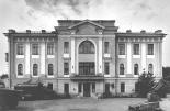
Vyborgskaya Side
VYBORGSKAYA SIDE, a historical district of St. Petersburg, on the right bank of the Neva River and the Bolshaya Nevka River. In the east, it is confined by the Chernaya Rechka River
|
|
|
|
|
hidden
|
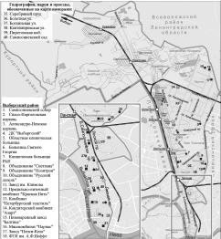
Vyborgsky District
VYBORGSKY DISTRICT is an administrative territorial unit of St. Petersburg. (Its territory administration is located at 86 Bolshoy Sampsonievsky Avenue) The district was founded in 1917; and its present-day territorial borders were established in
|
|
|
|
|
hidden
|
Yablonovka
YABLONOVKA, an area close to Ladozhskaya metro station, on the right bank of the Okkervil River. Since 1817, it was known as Bolshaya Yablonka village (since 1831 - Bolshaya Yablonovka). Malaya Yablonovka village was located about 1 km up-stream
|
|
|
|
|
hidden
|
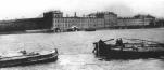
Zayachy Island
ZAYACHY ISLAND situated in the broadest part of the Neva. In the north, it is separated from Petrogradsky Island with Kronverksky Strait. The island is 28 hectares in area, 900 metres long, and 500 metres wide
|
|
|
|
|
hidden
|
Zelenogorsk town
ZELENOGORSK (until 1948 Terijoki), the former town, since 1998 - a municipal unit forming a part of Kurortny District of St. Petersburg, 46 km to the north-west of the city, in the resort area on the north coast of the Gulf of Finland
|
|
|
|
|
hidden
|
Zhernovka, locality
ZHERNOVKA, locality in the northern part of St. Petersburg. Its name derived from a former village, known from 1778, which was situated on the left bank of the Zhernovka River (the Lapka) at the place where the Zhernovka converged with the Okhta
|
|
|
|
|
hidden
|
Zoning (entry)
ZONING, division of the city territory into separate parts with the purpose of separate government or assigning different purposes to each zone according to some criterion. There are over 50 different variants of state and sectoral zoning in St
|
|
|
|
|
|