Authors
/
hidden
|
Gorelovo, locality
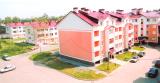
GORELOVO, an area in the south-west of St. Petersburg, along Tallinskoe Freeway, to the north of Krasnoe Selo. It was named after a village of the same name. In the 19th - early 20th centuries
|
|
|
|
|
hidden
|
Gorodskoy Island
GORODSKOY ISLAND, name of Petrogradsky Island in the first third of the 18th century. The first city buildings were constructed in the island near the present-day Troitskaya Square. Troitsky Island was another name used at that time.
Е. А
|
|
|
|
|
hidden
|
Gorskaya
GORSKAYA, locality in the southern part of Sestroretsk, east of Primorskoe Freeway. The territory incorporates a railway station of the same name within the railway line linking St. Petersburg and Sestroretsk and a summer settlement
|
|
|
|
|
hidden
|
Grazhdanka
GRAZHDANKA, an area to the north of St. Petersburg. Named after a German settlement (sometimes, referred to as Gorozhanka) that was formed in the second half of the 18th century on Staraya Murinskaya Road (the present-day site of Favorskogo Street)
|
|
|
|
|
hidden
|
Gryazny Island
GRYAZNY ISLAND situated between the Olkhovka River and the Ekaterinhofka River, south of where the Tarakanovka River flows into the latter. The name dates back to 1838
|
|
|
|
|
hidden
|
Gutuevsky Island
GUTUEVSKY ISLAND situated at the mouth of the Bolshaya Neva River and washed by Morskoy Canal in the west and the Ekaterinhofka River in the east. It is 320 hectares in area, 3.8 kilometres long and 1.2 kilometres wide
|
|
|
|
|
hidden
|
Harbour
HARBOUR is an area in the western part of Vasilievsky Island. Soon after the foundation of St. Petersburg, earthworks and the artillery battery were put up here to protect the entrance to the Bolshaya Neva River
|
|
|
|
|
hidden
|
Islands (entry)
ISLANDS. A characteristic trait of St. Petersburg is its many islands, as it is located on the Neva River delta. There were 33 islands with official names in St
|
|
|
|
|
hidden
|
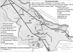
Kalininsky District
KALININSKY DISTRICT is an administrative territorial unit of St. Petersburg. (Its territory administration is located at 13 Arsenalnaya Embankment.) The district was named in honour of Mikhail Kalinin in 1946
|
|
|
|
|
hidden
|
Kamenka, area
KAMENKA (Bolshaya Kamenka, until 1930 - Koloniya Kamenka "Kamenka Colony"), the former village in the north-west of St. Petersburg, north of Yuntolovskaya Forest Estate, and north-west of the region of large-scale residential building of Dolgoe Lake
|
|
|
|
|
hidden
|
Kanonersky Island
KANONERSKY ISLAND situated in the southwest of the delta of the Neva River and separated from Gutuevsky Island by Morskoy Canal. In the west, it is bounded by the Gulf of Finland
|
|
|
|
|
hidden
|
Kantsevskaya Side
KANTSEVSKAYA Side, the name of the territory on the right bank of the Okhta River, at the confluence of the Okhta and the Neva, that was current in the 18th century. It comes from the Russian name of the former Swedish fortress Nyenschantz - Kantsi
|
|
|
|
|
hidden
|
Kazansky Island
KAZANSKY ISLAND, an area in the centre of St. Petersburg between the Moika River, Griboedova Canal, and Kryukov Canal. The area is over 120 hectares. It was a part of Pervushin Island that also included Kolomensky Island, Pokrovsky Island
|
|
|
|
|
hidden
|
Kirovskie Islands
KIROVSKIE ISLANDS, the official name of Elagin Island, Krestovsky Island, and Kamenny (Stone) Island in 1934-93, named in memory of S. M.
|
|
|
|
|
hidden
|
Kirovsky District
KIROVSKY DISTRICT is an administrative territorial unit of St. Petersburg. (Its territory administration is located at 18 Stachek Avenue). The district was named in honour of Sergey Kirov in 1934. Its present-day borders were established in 1973
|
|
|
|
|
hidden
|
Kolomensky Island
KOLOMENSKY ISLAND, historical name of the area between the Moika River, Kryukov Canal, Griboedova Canal, Fontanka River, Bolshaya Neva River, and Pryazhka River. Its area is over 90 hectares
|
|
|
|
|
hidden
|
Kolomna
KOLOMNA, a historical district in the west part of St. Petersburg, between the Bolshaya Neva, Moika, Fontanka and Kryukov Canal. The name appeared in the early 18th century, most likely, on account of working people from the town of Kolomna
|
|
|
|
|
hidden
|
Kolomyagi
KOLOMYAGI, an area to the north-west of St. Petersburg, north of the Komendantsky Aerodrome and south-west of Ozerki; in the west it is adjacent large-scale residential development of Ozero Dolgoe
|
|
|
|
|
hidden
|
Kolpinsky District
KOLPINSKY DISTRICT, an administrative and territorial unit of Saint Petersburg (with the territorial administration situated in Kolpino, at 1 Uritskogo Street). The name derives from the town of Kolpino which is the centre of the district
|
|
|
|
|
hidden
|
Koltovskie, locality
KOLTOVSKIE, historical name of a region in the western part of Petrogradsky Island between Pionerskaya Street (former Bolshaya Koltovskaya Street), Bolshaya Zelenina Street
|
|
|
|
|
hidden
|
Komarovo, village
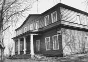
KOMAROVO (until 1948 Kellomaki), the former settlement (since 1946), a municipal unit forming a part of Kurortny District of St. Petersburg (since 1997), 40 km to the north-west of the city
|
|
|
|
|
hidden
|
Komendantsky Aerodrome
KOMENDANTSKY AERODROME, an area in the north-west of St. Petersburg, between Kolomyazhsky Avenue, Parashyutnaya Street, Sizova Street and Chernaya Rechka river
|
|
|
|
|
hidden
|
Kotlin, Island
KOTLIN, is an island in the east of the Neva Bay, in the Gulf of Finland. It is 23 kilometres west of Vasilievsky Island, 12 kilometres southwest of Gorskaya, and six kilometres north of Lomonosov
|
|
|
|
|
hidden
|
Krasnoe Selo, area
KRASNOE SELO, a town; since 1973, it formed a part of Krasnoselsky District of Leningrad; since 1997 - municipal unit; 26 km to the south-west of St. Petersburg centre, on Narva federal motorway. A railway station on the line St
|
|
|
|
|
hidden
|
Krasnogvardeysky District
KRASNOGVARDEYSKY DISTRICT is an administrative territorial unit of St. Petersburg. (Its territory administration is located at 52 Sredneokhtinsky Avenue). It was established in 1973. It was named in honour of the Petrograd Red Guards
|
|
|
|
|
hidden
|
Krasnoselsky District
KRASNOSELSKY DISTRICT is an administrative territorial unit of St. Petersburg. (Its territory administration is located at 3 Partizana Germana Street) Its present day borders were established in 1973. It was named after the town of Krasnoe Selo
|
|
|
|
|
hidden
|
Krasnye Zori
KRASNYE ZORI, a locality in the East of Petrodvortsovy District between Strelna and New Peterhof, also a railway platform along the Baltiyskaya Railway Line. The name derives from Krasnye Zori labour settlement school
|
|
|
|
|
hidden
|
Krestovsky Island
KRESTOVSKY ISLAND (Cross Island), situated between the Srednaya Nevka River separating it from Elagin Island, the Malaya Nevka River separating it from Petrovsky Island, Petrogradsky Island, Aptekarsky Island
|
|
|
|
|
hidden
|
Krivaya Damba
KRIVAYA DAMBA (Curved Dam) is an artificial island bent in its plan (hence the name). It appeared during the construction of the Commercial Sea Port of St. Petersburg in 1870s. It is about one kilometre long and a maximum of 100 metres wide
|
|
|
|
|
hidden
|
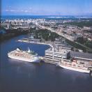
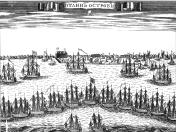
Kronstadt
KRONSTADT, a town on Kotlin Island, 32 kilometres west of Saint Petersburg. The town's history traces back to a sea fort called Kronslot built in the winter of 1703-04. By May 1704, two batteries were constructed along the south bank
|
|
|
|
|