Authors
/
hidden
|
Predportovaya
PREDPORTOVAYA, a zone with industrial and storage facilities located between Kubinskaya Street, Dunaysky Avenue, Pulkovskoe Highway and Varshavskaya Railway Line
|
|
|
|
|
hidden
|
Primorsky District
PRIMORSKY DISTRICT, an administrative and territorial unit of St. Petersburg, with its administration located at 83 Savushkina Street. Formed in 1936, known as Zhdanovsky District in 1949-89, and existing in its present day boundaries since 1973
|
|
|
|
|
hidden
|
Pulkovo area
PULKOVO, an area in the south of St. Petersburg, at the junction of Kievskoe Freeway and the road from the town of Pushkin. It is located on Pulkovo heights. Since the 15th century
|
|
|
|
|
hidden
|
Pushkin, town
PUSHKIN, a town and municipal unit situated south of Saint Petersburg. Known until 1918 as Tsarskoe Selo, and in 1918-37 as Detskoe Selo. As of 2002, population totalled approximately 95,000 inhabitants
|
|
|
|
|
hidden
|
Pushkinsky District
PUSHKINSKY DISTRICT, an administrative and territorial unit of St. Petersburg (with the territorial administration situated in the town of Pushkin, at 24 Oktyabrsky Boulevard)
|
|
|
|
|
hidden
|
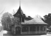
Razliv
RAZLIV, a locality in southern Sestroretsk, north of Tarkhovka, on the western bank of Lake Sestroretsky Razliv; also a railway station along the Saint Petersburg -Sestroretsk line
|
|
|
|
|
hidden
|
Repino, settlement
REPINO, a former settlement, known as Kuokkala until 1948; became a municipal unit within the Kurortny District in 1998; 37 kilometres northwest of Saint Petersburg, in a resort area on the northern coast of the Gulf of Finland; also a train station
|
|
|
|
|
hidden
|
Rezvy Maly Island
REZVY MALY ISLAND in the Ekaterinhofka River, downstream the mouth of the Tarakanovka River. It is linked to Gutuevsky Island via a wooden bridge. The island is about two hectares in area, 300 metres long, and 100 metres wide
|
|
|
|
|
hidden
|
Right Bank of the Neva River
RIGHT BANK OF THE NEVA RIVER, a general name of a vast territory on the right bank of the Neva River southwards from the Soyedinitelnaya railway line and the Okhta - Zanevsky Post stretch
|
|
|
|
|
hidden
|
Rubleviki
RUBLEVIKI, the historical name of an area to the north-east of St. Petersburg, between Bolshaya Okhta, Polyustrovo and Porokhovye. In 1913, a junction line of Finlyandskaya railroad was built through Rubleviki and the railway platform of the same
|
|
|
|
|
hidden
|
Ruchyi
RUCHYI, an area to the north-east of St. Petersburg, to the north of Piskarevka. It was named after a village located on the banks of Murinsky Stream (the site where it intersects present-day Grazhdansky Avenue) from the late 18th century to the
|
|
|
|
|
hidden
|
Rusanovka
RUSANOVKA, an area to the south-east boundary of St. Petersburg, at the end of Oktyabrskaya Embankment, on the site where the Utka River flows into the Neva. The region was named after landlords Rusanov
|
|
|
|
|
hidden
|
Rybatskaya
RYBATSKAYA, a former village, located along the right bank of the Okhta River, four kilometres downstream from the site where the Murinsky Stream flows into the Okhta river
|
|
|
|
|
hidden
|
Rybatskoe, area
RYBATSKOE, an area to the south-east of St. Petersburg, on the left bank of the Neva River, between the Murzinka River and the Slavyanka River. In 1716, Rybnaya (Fish) settlement was founded there at the Peter the Great’s decree
|
|
|
|
|
hidden
|
Rzhevka, area
RZHEVKA, an area in the north-east of St. Petersburg, on the left bank of the Okhta River, to the north-east of Porokhovye. Since the 1730s, the Rzhevskaya Settlement, owned by Captain V.F. Rzhevsky (hence the name), was located there
|
|
|
|
|
hidden
|
Rzhevka-Porokhovye
RZHEVKA-POROKHOVYE, an area of mass residential development in the east of St. Petersburg, between Irinovsky Avenue, Kommuny Street, Khasanskaya Street and Peredovikov Street
|
|
|
|
|
hidden
|
Saperny, settlement
SAPERNY, a municipal formation within the Kolpinsky District, far and southeast of Saint Petersburg, between the Neva River and the Saint Petersburg - Volkhovstroy railway line; also a railway station
|
|
|
|
|
hidden
|
Serovo
SEROVO (until 1948 Vammelsuu), formerly a village, since 1998 - a municipal establishment forming a part of Kurortny District, in the recreational zone on the north coast of the Gulf of Finland
|
|
|
|
|
hidden
|
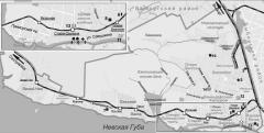
Sestroretsk, town
SESTRORETSK, formerly a town; since 1998, a municipal unit, the centre of the Kurortny District, located in the resort area on the Gulf of Finland's northern coast. As of 2001, the population totaled 32,200 inhabitants
|
|
|
|
|
hidden
|
Settlements(entry)
SETTLEMENTS (sloboda), St. Petersburg settlements set on separate territories and featuring homogeneous social structure. The population of a settlement is united by occupation, estate, parentage or religion
|
|
|
|
|
hidden
|
Severo-Primorskaya Part
SEVERO-PRIMORSKAYA PART, a territory to the north-west of St. Petersburg, between Lake Lakhtinsky Razliv, Bogatyrsky Avenue, Torfyanaya Road and Staraya Derevnya
|
|
|
|
|
hidden
|
Shchemilovka
SHCHEMILOVKA, an area to the south-east of St. Petersburg, between Farforovskaya Street, the Neva River, Lesnozavodskaya Street, Krasnykh Zor Boulevard and Sortirovochnaya Station of Moskovskaya Railway Line
|
|
|
|
|
hidden
|
Shrenk L.I., (1826-1894), ethnographer and geographer
SHRENK Leopold Ivanovich (1826-1894, St. Petersburg), geographer, ethnographer, zoologist, and explorer of Siberia and Far East, member of the Petersburg Academy of Sciences in 1865. He graduated from Derpt University in 1850
|
|
|
|
|
hidden
|
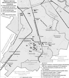
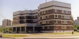
Shushary
SHUSHARY, a municipal unit of Pushkinsky District, 14 kilometres to the south of St. Petersburg, at the intersection of the Russia federal highway and Vitebsk Railway Line (and railway station). The population consists of about 6,000 people (2002)
|
|
|
|
|
hidden
|
Shuvalovo
SHUVALOVO, a locality in the northern part of Saint Petersburg along the banks of Lake Bolshoe (Nizhnee) Suzdalskoe. Shuvalovo is bounded by the Vyborgskoe Highway on the east, adjoining Pargolovo on the north, and Ozerki on the south
|
|
|
|
|
hidden
|
Shuvalovo-Ozerki
SHUVALOVO-OZERKI, the region of large-scale residential development in the north of St. Petersburg, between Vyborgskoe Freeway in the west, the line of circular railway in the north, Svetlanovsky Avenue in the east and Severny Avenue in the south
|
|
|
|
|
hidden
|
Smolenskoe Field, area
SMOLENSKOE FIELD, the historical name of the area located in the central part of Vasilievsky Island, between Nineteenth Line in the east, Smolenskoe Cemetery (hence the name) in the north and the harbour in the east
|
|
|
|
|
hidden
|
Smolenskoe Village
SMOLENSKOE VILLAGE, a historical region on the left bank of the Neva River, on the territory of Nevskaya Zastava, between Bolshoy Smolensky Avenue and Krupskoy Street
|
|
|
|
|
hidden
|
Smolyachkovo
SMOLYACHKOVO (until 1948 Ino), the former village, since 1998 - a municipal establishment forming part of Kurortny District, in the resort zone on the north coast of the Gulf of Finland, on the boundary with Leningrad Region
|
|
|
|
|
hidden
|
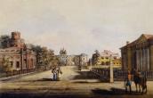
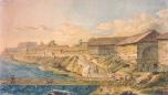
Sofia
SOFIA, the historical name of the town of Pushkin to the south of Catherine Park, between Pavlovskoe Freeway and Krasnoselskoe Freeway. It was founded in 1785 by Empress Catherine II as a chief town of the district. In 1782-88, St
|
|
|
|
|