Authors
/
hidden
|
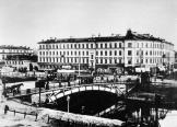
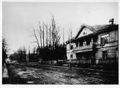
Moshkov Lane
MOSHKOV LANE named Zaporozhsky Lane after a Ukrainian city in 1952-89, between Dvortsovaya Embankment and Moika River Embankment. It was laid in the first quarter of the 18th century and named after houseowner and Master of the Household P. I
|
|
|
|
|
hidden
|
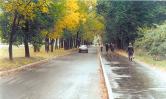
Moskovskoe Freeway
MOSKOVSKOE FREEWAY, between Pobedy Square and line of the Circular Railway, continues Moskovsky Avenue. It appeared in the first quarter of the 18th century as the road to Sarskaya Myza (Tsarskoe Selo) and further on to Novgorod and Moscow (in the
|
|
|
|
|
hidden
|
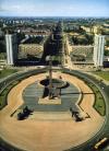
Moskovsky Avenue
MOSKOVSKY AVENUE (in 1918-50 - Mezhdunarodny Avenue, in 1950-56 - Stalina Avenue, after I.V. Stalin), from Sennaya Square to Pobedy Square, one of the main thoroughfares of St
|
|
|
|
|
hidden
|
Muzhestva Square
MUZHESTVA SQUARE known as Murinskaya or Spasskaya Square before 1965, between Karbysheva Street, Politekhnicheskaya Street, Second Murinsky Avenue, Toreza Avenue, and Nepokorennykh Avenue
|
|
|
|
|
hidden
|
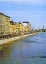
Mytninskaya Embankment
MYTNINSKAYA EMBANKMENT stretching from Kronverksky Avenue to Dobrolyubova Avenue along Kronverksky Channel and the Malaya Neva River in the southern extremity of Petrogradsky Island at the approach of Birzhevoy Bridge
|
|
|
|
|
hidden
|
Narodnogo Opolchenia Avenue
NARODNOGO OPOLCHENIA AVENUE translated as Avenue of the People's Volunteer Corps, lying between Krasnoputilovskaya Street and Letchika Pilyutova Street and crossing districts of Knyazhevo, Dachnoe, Ulyanka, Ligovo, and Sosnovaya Polyana
|
|
|
|
|
hidden
|
Nepokorennykh Avenue
NEPOKORENNYKH AVENUE translated as the Avenue of the Unconquered, a part of the central ring road running between Muzhestva Square and Piskarevsky Avenue and crossing Kushelevka and Piskarevka
|
|
|
|
|
hidden
|
Novo-Admralty Canal
NOVO-ADMIRALTY CANAL (New Admiralty Canal) flowing from the confluence of the Moika River and the Admiraly Canal to the Bolshaya Neva was dug in the first quarter of the 18th century
|
|
|
|
|
hidden
|
Novo-Izmailovsky Avenue
NOVOIZMAILOVSKY AVENUE between Blagodatnaya Street and Konstitutsii Square. It was laid close to the former Korpusnoe Highway in the same direction as one of the three radial roads - Voznesensky Avenue and Izmailovsky Avenue (hence the name
|
|
|
|
|
hidden
|
Novosmolenskaya Embankment
NOVOSMOLENSKAYA EMBANKMENT known as Oktyabrskaya Embankment in 1976-87 and Smolenka River Embankment in 1987-89. It was laid downstream the Smolenka River along both banks of the straightened riverbed between Nalichnaya Street and Morskaya
|
|
|
|
|
hidden
|
Obukhovskoy Oborony Avenue
OBUKHOVSKOY OBORONY AVENUE from Alexandra Nevskogo Square to Karavaevskaya Street. It was laid in the early 18th century as a road to Arkhangelsk through Shlisselburg and was known as Shlisselburgskaya Road, Shlyutenburgskaya Road
|
|
|
|
|
hidden
|
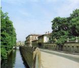
Obvodny Canal
OBVODNY CANAL flows from the Neva River in the area of Alexander Nevsky Lavra to the Ekaterinhofka River (8.08 km long, 21.3 meters wide and 42.6 meters wide in its eastern part)
|
|
|
|
|
hidden
|
Oktyabrskaya Embankment
OKTYABRSKAYA EMBANKMENT translated as October Embankment and known as Pravogo Berega Nevy Embankment before 1973. It runs between Zolnaya Street and Novosaratovka Settlement and crosses a number of settlements such as Klochki
|
|
|
|
|
hidden
|
Perinnaya Line
PERINNAYA LINE lying along Bolshoy Gostiny Dvor between Nevsky Prospect and Lomonosova Street. In the mid-to-late 19th century, it was known as Surovskaya, or Bolshaya Surovskaya, Line (Textile Line) so named because of the goods sold in the line
|
|
|
|
|
hidden
|
Pesochnaya Embankment
PESOCHNAYA EMBANKMENT situated on Aptekarsky Island between Kamennoostrovsky Avenue and Karpovka River Embankment. It was laid on the left bank of the Malaya Nevka River in 1820s and named Pesochnaya Embankment (Sand Embankment) because of the sandy
|
|
|
|
|
hidden
|
Petrograd
PETROGRAD, official name of St. Petersburg since 18 August 1914, chosen after Russia entered the First World War of 1914-18; it replaced the German name St. Petersburg
|
|
|
|
|
hidden
|
Petrogradskaya Embankment
PETROGRADSKAYA EMBANKMENT known as Peterburgskaya Embankment until 1914. It lies between Petrovskaya Embankment and Karpovka River Embankment on the left bank of the Neva River in the east of Petrogradsky Island (hence the name)
|
|
|
|
|
hidden
|
Petrovskaya Embankment
PETROVSKAYA EMBANKMENT lying between Troitskaya Square and Petrogradskaya Embankment on the right bank of the Neva River on Petrogradskaya Side. It appeared in what was then the city centre in the 1700s as the first embankment of St. Petersburg
|
|
|
|
|
hidden
|
Pirogovskaya Embankment
PIROGOVSKAYA EMBANKMENT on the right bank of the Bolshaya Nevka River between Akademika Lebedeva Street and Maly Sampsonievsky Avenue. It consists of two sections. The first section, named after N. I
|
|
|
|
|
hidden
|
Pisareva Street
PISAREVA STREET known as Shafirovskaya Street from the mid-19th century and named Alexeevskaya Street after Grand Prince Alexey Alexeevich in 1887-1923 who had a palace at 122 Moika River Embankment
|
|
|
|
|
hidden
|
Piskarevsky Avenue
PISKAREVSKY AVENUE between Sverdlovskaya Embankment and the upper Okhta River near Novaya Village. It crosses Polyustrovo, Piskarevka (hence the name), and Ruchi
|
|
|
|
|
hidden
|
Pochtamtskaya Street
POCHTAMTSKAYA STREET, between St. Isaac's Square and Konnogvardeisky Lane. The road was built in the first quarter of the 18th century, in the 1730s it was known as Pushkarskaya Street (after Pushkarskaya, meaning Artillerymen, settlement)
|
|
|
|
|
hidden
|
Podyacheskaya Bolshaya Street
PODYACHESKAYA BOLSHAYA STREET located between Griboedova Canal and the Fontanka River. The name was given in the second half of the 18th century after the occupation of its residents - podyachie (petty officers)
|
|
|
|
|
hidden
|
Podyacheskaya Srednaya Street
PODYACHESKAYA SREDNAYA STREET joins Griboedova Canal Embankment in its bend in the region of its intersection with Rimskogo-Korsakova Avenue. Since 1739 - Prikaznaya Admiralteiskaya Street
|
|
|
|
|
hidden
|
Posadskaya Malaya Street
POSADSKAYA MALAYA STREET, on Petrogradskaya Side, between Kamennoostrovsky Avenue and Chapaeva Street. The road appeared in the 1720s in the settlement of craftspeople and tradespeople, transferred to St
|
|
|
|
|
hidden
|
Povarskoy Lane
POVARSKOY LANE (originally called Basmannaya Street; in the 1770s, it was renamed Povarskaya Street, remained as such until the 1790s), between Stremyannaya Street and Kolokolnaya Street. It was built in the 1740s, following the designs of the St
|
|
|
|
|
hidden
|
Primorskoe Freeway
PRIMORSKOE FREEWAY, goes along the shore of the Gulf of Finland (hence the name, that appeared in 1974) through Sestroretsk town and villages of Kurortny District of St. Petersburg
|
|
|
|
|
hidden
|
Primorsky Avenue
PRIMORSKY AVENUE, between Akademika Krylova Street and Savushkina Street, goes along the right bank of the Neva River, through Staraya Derevnya and Novaya Derevnya to Lake Lakhtinsky Razliv, extends Ushakovskaya Embankment
|
|
|
|
|
hidden
|
Professora Popova Street
PROFESSORA POPOVA STREET (in the 1810s - Pesochny Avenue, from the middle of the 19th century to 1940 - Pesochnaya Street), between Aptekarskaya Embankment and Pesochnaya Embankment, on Aptekarsky Island
|
|
|
|
|
hidden
|
Proletarskoy Diktatury Square
PROLETARSKOY DIKTATURY SQUARE (until 1864 - Orlovskaya Square, in 1864-1918 - Lafonskaya Square, in 1918-52 - Diktatury Square), between Suvorovsky Avenue, Proletarskoy Diktatury Street and Tverskaya Street
|
|
|
|
|