|
|
|
История переименований:
Petergofskoe Freeway
(as of November 12, 1962)
Leningradskoe Freeway
(May 9, 1924 – November 12, 1962)
Stachek Ave
(1948 - November 12, 1962)
Petergofskaya Road
(1758 – the 1830s)
Petrogradskoe Freeway
(1914 - May 9, 1924)
Peterburgskoe Freeway
(the 1870s – 1914)
Peterburgskaya Road
(the 1830s – the 1870s)
Petrodvortsovoe Freeway
(1948- November 12, 1962)
hidden
|
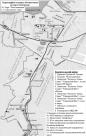
Central Ring Route
CENTRAL RING ROUTE, motor transport system, one of the main lines of St. Petersburg. The creation of Central Ring Route was to eliminate transit freight transport from the city
|
|
|
|
|
hidden
|
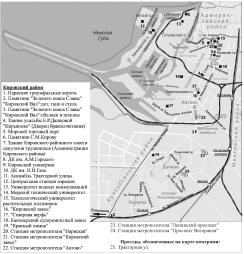
Kirovsky District
KIROVSKY DISTRICT is an administrative territorial unit of St. Petersburg. (Its territory administration is located at 18 Stachek Avenue). The district was named in honour of Sergey Kirov in 1934. Its present-day borders were established in 1973
|
|
|
|
|
hidden
|
Krasnoselsky District
KRASNOSELSKY DISTRICT is an administrative territorial unit of St. Petersburg. (Its territory administration is located at 3 Partizana Germana Street) Its present day borders were established in 1973. It was named after the town of Krasnoe Selo
|
|
|
|
|
hidden
|
Ligovo, village
LIGOVO, a historical district in the south-west of St. Petersburg, between Peterhofskoye Highway, Marshala Zhukova Avenue, Baltiiskaya Railway Line and the Ivanovka River
|
|
|
|
|
hidden
|
Natural sights
NATURAL SIGHTS, natural formations, typical of certain processes and phenomena and as a rule specific within surrounding scenery; they can be divided into geological, geomorphological, botanic, hydrological sights etc
|
|
|
|
|
hidden
|
Petergofskaya Road
PETERGOFSKAYA ROAD (Petergofskaya Pershpektiva), name of Narvskaya Road between St. Petersburg and Peterhof in the 18th century. The road ran along the southern coast of the Gulf of Finland in place of the present-day Staro-Petergofsky Avenue
|
|
|
|
|
hidden
|
Relief
RELIEF. Despite having a general plain character, its flatness and large built up areas, the relief of St. Petersburg is diverse and full of contrasts. The highest peaks in the southwest of the city reach 176 meters
|
|
|
|
|
hidden
|
South-West
South-West, the region of large-scale residential development, a part of Krasnoselsky District territory to the north of Petergofskoe Freeway and to the west from Stachek Avenue
|
|
|
|
|
hidden
|
Stachek Avenue
STACHEK AVENUE, called Petergofskoe Highway until 1923, then known as Stachek Street until 1940, between Stachek Square and the place where Marshala Zhukova Avenue and Petergofskoe Freeway intersect
|
|
|
|
|
hidden
|
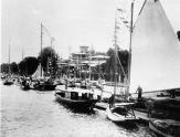
Yacht Clubs (entry)
YACHT CLUBS. Nevsky Flot (Nevskaya Flotiliya) was the first yacht club in Russia. It was founded by order of tsar Peter the Great on 12.4.1718 and had its own flag. It was given 141 small ships "to entertain people" in perpetual tenure
|
|
|
|
|
hidden
|
Yuzhno-Primorsky Park
YUZHNO-PRIMORSKY PARK is surrounded by the Peterhof Highway to the South and Doblesti Street to the East and faces towards the Gulf of Finland to the north-west and north. The total area is 58 hectares
|
|
|
|
|
|