hidden
|
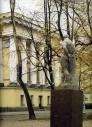
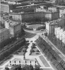
50th Anniversary of October Memorial Park
50TH ANNIVERSARY OF OCTOBER MEMORIAL PARK is located in the north-east of St. Petersburg, in Polyustrovo, between Metallistov Avenue, Revolyutsii Highway and Marshala Tukhachevskogo Street. The total area of the park is 32 hectares
|
|
|
|
|
hidden
|
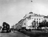
Admiralteiskaya Embankment
ADMIRALTEISKAYA EMBANKMENT, in 1918-44 - Roshalya Embankment in honour of revolutionary S. G. Roshal (1896-1917), lying between Dvortsovy Avenue and Dekabristov Square
|
|
|
|
|
hidden
|
Admiralteisky Avenue
ADMIRALTEISKY AVENUE (Admiralty Avenue) in the mid-to-late 18th century - Admiralteiskaya Street or Bolshaya Street, in 1918-44 - Roshalya Avenue in honour of revolutionary S. G. Roshal (1896-1917). A link between Palace Square and St
|
|
|
|
|
hidden
|
Admiralteisky District
ADMIRALTEISKY DISTRICT, (Admiralty) an administrative territorial unit of St. Petersburg (Its territory administration is located at 10 Izmailovsky Avenue), is one of the central districts of the city
|
|
|
|
|
hidden
|
Admiralteyskaya Side
ADMIRALTEYSKAYA SIDE, a historical name of the central part of St. Petersburg bound on the north by the Neva river and on the south by the Moika River. Formed in the early 18th century when the General Admiralty
|
|
|
|
|
hidden
|
Admiralteysky Islands
ADMIRALTEYSKY ISLANDS, two islands, first and second, situated in the centre of St. Petersburg between the Bolshaya Nevka River and the Moika River. The first Admiralteysky Island is between Lebyazhy Canal and Winter Canal and Second Admiralteysky
|
|
|
|
|
hidden
|
Admiralty Canal
ADMIRALTY CANAL was dug from the eastern ditch of the Amiralty Fortress (today, the Dvortsovy Bridge ramp to the Palace Square) to the Moika River to connect the Admiralty Shipyard with Galerny Dvor (Galley Yard) and warehouses of New Holland
|
|
|
|
|
hidden
|
Alexandria, palace and park ensemble (Peterhof)
ALEXANDRIA, palace and park ensemble of Peterhof located to the east of the Lower Park and occupying a territory of 115 hectares. Since 1711, the estate of A.D
|
|
|
|
|
hidden
|
Alexandrino, forest park
ALEXANDRINO forest park is situated in the southwest part of St. Petersburg, between Narodnogo Opolcheniya Avenue, Stachek Avenue and Kozlova Street. It includes a park which formerly possessed the same name
|
|
|
|
|
hidden
|
Alexandrovskaya (Kurortny District)
ALEXANDROVSKAYA, locality in the southern part of Sestroretsk, bordering on Gorsky Stream on the south and Lake Sestroretsky Razliv on the north, taking up either side of Primorskoe Freeway
|
|
|
|
|
hidden
|
Alexandrovskaya (Pushkinsky District)
ALEXANDROVSKAYA, municipal unit within the structure of Pushkinsky District of St. Petersburg, located on the banks of the Kuzminka River. The settlement also comprises a railway station of the same name
|
|
|
|
|
hidden
|
Alexandrovskoe, region
ALEXANDROVSKOE, an area to the south-east of St. Petersburg, confined by Zaporozhskaya Street, Moskovskaya Line of Oktyabrskaya Railway, Alexandrovskoy Fermy Avenue, Novo-Alexandrovskaya Street and the Neva River
|
|
|
|
|
hidden
|
Alexandrovsky Garden
ALEXANDROVSKY GARDEN (in 1920-89 - the Maxim Gorky Workers' Garden, in 1989-97 - Admiralty Garden) is situated along the south and the west facades of the Main Admiralty, with an area of 10 hectares. In 1805-06, gardener W
|
|
|
|
|
hidden
|
Alexandrovsky Parade Ground
ALEXANDROVSKY PARADE GROUND, the historical name of the territory in the south-west of the city center, around the Alexander Nevsky Lavra, north of Obvodnoy Canal and west of the Monastyrka River
|
|
|
|
|
hidden
|
Alexandrovsky Park
ALEXANDROVSKY PARK (Pushkin town), a landscape monument, situated to the west of Catherine Park, forming a part of the Tsarskoe Selo palace park ensemble and comprising of 120 hectares
|
|
|
|
|
hidden
|
Alexandrovsky Park (Pushkin)
ALEXANDROVSKY PARK (Pushkin), a landscape architecture monument, situated west of Ekaterininsky Park. The park is a part of Tsarskoe Selo palace and park ensemble. Alexandrovsky Park covers an area of 120 hectares
|
|
|
|
|
hidden
|
Angliiskaya Embankment
ANGLIISKAYA EMBANKMENT, from 1738 - Beregovaya Nizhnaya Embankment Street, in the mid-to-late 18th century - Isaakievskaya Embankment, Galernaya Embankment, and Anglinskaya Embankment, from 1800s - Angliiskaya Embankment
|
|
|
|
|
hidden
|
Angliisky Avenue
ANGLIISKY AVENUE, from 1771 - Aglinskaya Perspective or Anglinsky Avenue; from 1846 it possessed its present-day name; in 1918-94 - Maklina, or MacLean, Avenue in honour of English socialist John MacLean (1879-1923) elected an honorary deputy
|
|
|
|
|
hidden
|
Aptekarsky Island
APTEKARSKY ISLAND, (Apothecary Island), situated in the estuary of the Neva River between the Karpovka River separating it from Petrogradsky Island, Malaya Nevka River, and Bolshaya Nevka River. It is 198 hectares in area, 2.7 kilometres long and 1
|
|
|
|
|
hidden
|
Aptekarsky Lane
APTEKARSKY LANE, translated as Pharmacy Lane, between Millionnaya Street and Moika River Embankment. It was laid in 1730s and called Aptekarskaya Street from the early 1730s to 1780s. The lane was so named after the Central Pharmacy moved from SS
|
|
|
|
|
hidden
|
"Aquarium"
"AQUARIUM", an entertainment theatre-garden, set by entrepreneur G.A. Alexandrov (died in 1910), who took a lease on a piece of land at Kamennoostrovsky Avenue in 1886 (on the site of present-day houses Nos
|
|
|
|
|
hidden
|
Arsenalnaya Embankment
ARSENALNAYA EMBANKMENT on the right bank of the Neva River between Arsenalnaya Street and Akademika Lebedeva Street. It was so named in 1887 after Novy Arsenal Plant (today, Arsenal Joint-Stock Company situated in house 1)
|
|
|
|
|
hidden
|
Aviagorodok
AVIAGORODOK, an area in St. Petersburg's Moskovsky District, in the southern part of the city, west of Pulkovskoe Highway and near the Airport Railway Station. In 1931-41, it was Leningrad's main airport and included a living bloc for its staff
|
|
|
|
|
hidden
|
Aviators' Park
AVIATORS' PARK is situated in the southern part of St. Petersburg, between Novo-Izmailovsky Avenue and Basseynaya, Kubinskaya, and Kuznetsovskaya Streets, occupying as total 35.2 hectares
|
|
|
|
|
hidden
|
Avtovo
AVTOVO, an area in the southwest part of St. Petersburg, bordered by the Krasnenkaya River on the south and Komsomolskaya Square on the north. The name origin traces back to the Finnish village of Autovo (Auktovo)
|
|
|
|
|
hidden
|
Babolovsky Park (Pushkin town)
BABOLOVSKY PARK (Pushkin town), a monument of landscape architecture situated in the southwestern part of Pushkin town is a part of Tsarskoe Selo palace park ensemble. Its area consists of 268,8 hectares
|
|
|
|
|
hidden
|
Babushkina Park
BABUSHKINA PARK, located at 149 Obukhovskoy Oborony Avenue, is situated in the southeast of St. Petersburg, on the left bank of Neva, between Obukhovskoy Oborony Avenue, Zheleznodorozhny Avenue, Farforovskaya Street and Babushkina Street
|
|
|
|
|
hidden
|
Bakunina Avenue
BAKUNINA AVENUE between Nevsky Prospect and Sinopskaya Embankment. It was laid in the mid-to-late 18th century. Known as Malo-Okhtinsky Ferry Avenue in the late 18th century, it was renamed as Malookhtinsky Avenue in 1820-71
|
|
|
|
|
hidden
|
Barmaleeva Street
BARMALEEVA STREET situated in Petrogradskaya part between Bolshaya Pushkarskaya Street and Chkalovsky Avenue. It was laid in the settlement of St. Petersburg Regiment in 1730s and named after landowner Major Stepan Barmaleev in the late 18th century
|
|
|
|
|
hidden
|
Baskov Lane
BASKOV LANE between Korolenko Street and Fontannaya Street. The street was named after landowner and merchant Baskov in 1800s. The street was laid in the mid-18th century up to the present-day Radishcheva Street and extended up to Fontannaya Street
|
|
|
|
|