hidden
|
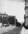
Sampsonievsky Bolshoy Avenue
SAMPSONIEVSKY BOLSHOY AVENUE, named Samsonievskaya Street in 1739, then B. Samsonievsky Avenue in the early 19th century, receiving its present name in the late 19th century
|
|
|
|
|
hidden
|
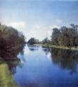
Samsonovsky Canal
SAMSONOVSKY CANAL (Samsonovsky Pipeline), an artificial hydraulic construction, a part of the water supply system of Peterhof fountains and ponds. It starts from Bolshoy Krugly Pond of Meadow (Lake) Park and ends in Colonists Park by Olgin Pond
|
|
|
|
|
hidden
|
Saperny Lane
SAPERNY LANE, between Mayakovskogo Street and Radishcheva Street. From the late 18th century, the road was known as Second Grafsky Lane, in the early 19th century - Kuznechny Lane
|
|
|
|
|
hidden
|
Saperny, settlement
SAPERNY, a municipal formation within the Kolpinsky District, far and southeast of Saint Petersburg, between the Neva River and the Saint Petersburg - Volkhovstroy railway line; also a railway station
|
|
|
|
|
hidden
|
Schuchye Lake (Komarovo)
SCHUCHIYE LAKE is located in Korelian Isthmus among moraine hills, 3 km to the north of Komarovo village. It is 1.1 km long, about 0.6 km wide and over 5 meters deep. This recreation zone has a lot of health and holiday centres
|
|
|
|
|
hidden
|
Seldyanoy Canal
SELDYANOY CANAL was dug on Gutuyevsky Island from the Ekaterinhofka River in 1827-38 after the catastrophic flood of 1824 (the soil was used to extend the territory). It was 450 meters long with a 200 meters deviation in the middle
|
|
|
|
|
hidden
|
Semenovskaya Square, architectural ensemble
SEMENOVSKAYA SQUARE, located at the intersection of Gorokhovaya Street and Fontanka River Embankment, near Semenovsky bridge. The dimensions and configuration of the bridge square consisting of two parts (rectangular on the right bank of the
|
|
|
|
|
hidden
|
Sementsy, area
SEMENTSY, the historical name of the area between Zagorodny Avenue and Obvodny Canal. The name comes from the 18th century settlement of Semenovsky Life Guard Regiment that was quartered on the territory from Zvenigorodskaya Street to Moskovsky
|
|
|
|
|
hidden
|
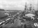
Sennaya Square
SENNAYA SQUARE (from 1952 to 1991 - Mira Square), located at the intersection of Sadovaya Street (some buildings numbered) and Moskovsky Avenue. The St. Petersburg Construction Commission proposed the construction of an extensive square on this site
|
|
|
|
|
hidden
|
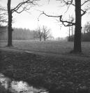
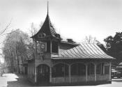
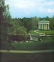
Separate Park, The
The Separate Park with the Colonist Pond ( it is situated along Pavlovsk Road). It was laying out by the architect A.A.Menelaws and gardeners F.F. Lyamin and I.F. Piper in 1824 - 1825. It was partly replaned in the middle of the 19th cent
|
|
|
|
|
hidden
|
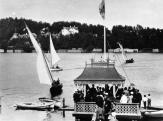
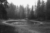
Serebryany Pond
SERBRYANY POND (Silver) was created in 1856 as an element of a landscape park. It is located between Orbeli Street, Malaya Obyezdnaya Street and Institutsky Avenue and stretches parallel to the 2nd Muromsky Avenue
|
|
|
|
|
hidden
|
Serovo
SEROVO (until 1948 Vammelsuu), formerly a village, since 1998 - a municipal establishment forming a part of Kurortny District, in the recreational zone on the north coast of the Gulf of Finland
|
|
|
|
|
hidden
|
Sestra, river
SESTRA, a river in the north-west of St. Petersburg, which flows through Sestroretsky District and Kurortny District. The Novgorod Pistsovye Books (Property Registers) of the 15th century record the river as Sestreya (from Finnish word meaning
|
|
|
|
|
hidden
|
Sestroretsk, town
SESTRORETSK, formerly a town; since 1998, a municipal unit, the centre of the Kurortny District, located in the resort area on the Gulf of Finland's northern coast. As of 2001, the population totaled 32,200 inhabitants
|
|
|
|
|
hidden
|
Sestroretsky Razliv, lake
SESTRORETSKY RAZLIV is an artificial reservoir in the region of the city of Sestroretsk. It was built during the construction of the armory (see Sestroretsk Toolmaker) by putting up culverts on the Sestra River (hence
|
|
|
|
|
hidden
|
Settlements(entry)
SETTLEMENTS (sloboda), St. Petersburg settlements set on separate territories and featuring homogeneous social structure. The population of a settlement is united by occupation, estate, parentage or religion
|
|
|
|
|
hidden
|
"Severnaya Palmyra"(North Palmyra)
"SEVERNAYA PALMYRA" (North Palmyra) is a poetic name of St. Petersburg that came into Russian literature in the second half of the 18th century. In the ancient times
|
|
|
|
|
hidden
|
Severo-Primorskaya Part
SEVERO-PRIMORSKAYA PART, a territory to the north-west of St. Petersburg, between Lake Lakhtinsky Razliv, Bogatyrsky Avenue, Torfyanaya Road and Staraya Derevnya
|
|
|
|
|
hidden
|
Severo-Primorsky Forest Park
SEVERO-PRIMORSKY FOREST PARK is located on the northern shore of the Gulf of Finland. It stretches from Lisy Nos to Olgino. To the north of the park is the St. Petersburg -Vyborg freeway. The total area is 600 hectares and extends six kilometres
|
|
|
|
|
hidden
|
Shchemilovka
SHCHEMILOVKA, an area to the south-east of St. Petersburg, between Farforovskaya Street, the Neva River, Lesnozavodskaya Street, Krasnykh Zor Boulevard and Sortirovochnaya Station of Moskovskaya Railway Line
|
|
|
|
|
hidden
|
Shkipersky Canal
SHKIPERSKY CANAL, built in the 1720s in the west part of Vasilivsky Island, it was named after skippers' settlement that once existed on this site. The canal joins Galley Harbour and Nevsky Bay (reserved for ship navigation)
|
|
|
|
|
hidden
|
Shkipersky Canal
SHKIPERSKY CANAL (Skippers' Canal) (before 1859, Chernaya Rechka (the Black River) or Glukhoy Protok (the Dead Canal), a small river in the western part of Vasilievsky Island
|
|
|
|
|
hidden
|
Shpalernaya Street
SHPALERNAYA STREET, from Gagarinskaya Street to Rastrelli Square. The street was known as First Line until 1727, then was called First Beregovaya Street. In the late 18th century it assumed the name Voskresenskaya Street or Voskresenskaya Embankment
|
|
|
|
|
hidden
|
Shushary
SHUSHARY, a municipal unit of Pushkinsky District, 14 kilometres to the south of St. Petersburg, at the intersection of the Russia federal highway and Vitebsk Railway Line (and railway station). The population consists of about 6,000 people (2002)
|
|
|
|
|
hidden
|
Shuvalovo
SHUVALOVO, a locality in the northern part of Saint Petersburg along the banks of Lake Bolshoe (Nizhnee) Suzdalskoe. Shuvalovo is bounded by the Vyborgskoe Highway on the east, adjoining Pargolovo on the north, and Ozerki on the south
|
|
|
|
|
hidden
|
Shuvalovo-Ozerki
SHUVALOVO-OZERKI, the region of large-scale residential development in the north of St. Petersburg, between Vyborgskoe Freeway in the west, the line of circular railway in the north, Svetlanovsky Avenue in the east and Severny Avenue in the south
|
|
|
|
|
hidden
|
Shuvalovsky Park
SHUVALOVSKY PARK is located between the village Pargolovo and the Zamanilovka River. It is a landscape architectural monument of the 19th century. The total area of the park is 134.5 hectares
|
|
|
|
|
hidden
|
Sinopskaya Embankment
SINOPSKAYA EMBANKMENT, on the left bank of the Neva River, from Smolny Avenue to Alexandra Nevskogo Square. In the first half of the 18th century, it was called Naberezhnaya Street or Nevskaya Rozhdestvenskaya Embankment
|
|
|
|
|
hidden
|
Slavy Avenue
SLAVY AVENUE, between Vitebskaya Railway Line and Moskovskaya Railway Line. It was named in 1964 in honour of the military victories and feats of labour of Leningrad citizens
|
|
|
|
|
hidden
|
Slavyanka, river
SLAVYANKA, a river in the south-east of St. Petersburg, a left tributary of the Neva River, which flows into the latter 27 kilometres above the mouth of the Neva
|
|
|
|
|