hidden
|
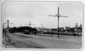
Strelna
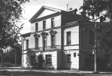
STRELNA, formerly a settlement, a municipal unit within the Petrodvortsovy District since 1997; 19 kilometers southwest of Saint Petersburg, on the southern coast of the Gulf of Finland, where it meets the Strelka River
|
|
|
|
|
hidden
|
Stroganovsky Garden
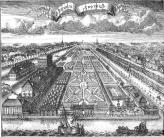
STROGANOVSKY GARDEN is located between Ushakovskaya Embankment and Chernaya Rechka River, near the inflow to the Bolshaya Nevka River. The garden was laid out at the end of the 18th century in the estate of Count A. S. Stroganov, hence the name
|
|
|
|
|
hidden
|
Summer Garden
SUMMER GARDEN (Dvortsovaya Embankment), an 18th-19th century landscaping monument. It is the oldest city garden in the central part of St. Petersburg, and is situated on the left bank of Neva, on an island formed by Fontanka River
|
|
|
|
|
hidden
|
Summer Residences (entry)
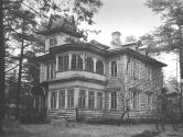
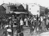
SUMMER RESIDENCES, places for recreation during the summer for St. Petersburg residents. Before the construction of railways, well off St. Petersburg residents spent their holidays in owned or rented summerhouses close to the city
|
|
|
|
|
hidden
|
Suvorovsky Avenue
SUVOROVSKY AVENUE, from Nevsky Prospect to Proletarskoy Diktatury Square. The avenue was laid in the mid-18th century. It ran from the Elephant Yard (a menagerie) which used to occupy the site of the present-day Oktyabrskaya Hotel
|
|
|
|
|
hidden
|
Suzdalsky Lakes
SUZDALSKY LAKES include three meridional reservoirs in the northern St. Petersburg, Shuvalovo and Ozerki. They received their name from Suzdal settlement once existing in this area
|
|
|
|
|
hidden
|
Sverdlovskaya Embankment
SVERDLOVSKAYA EMBANKMENT (in 1887-1925 - Polyustrovskaya Embankment, after the area of Polyustrovo), on the right bank of the Neva River, between Arsenalnaya Street and Krasnogvardeiskaya Square. It was named after Y.M. Sverdlov
|
|
|
|
|
hidden
|
Svetlanovsky Avenue
SVETLANOVSKY AVENUE, between Svetlanovskaya Square and Suzdalsky Avenue. The avenue was built in the first half of the 20th century. In the 1910s, the lot between modern Toreza Avenue and Jacques Duclos Street was constructed and given the name
|
|
|
|
|
hidden
|
Tarakanovka, river
TARAKANOVKA, a river in the west of St. Petersburg, a tributary to the Ekaterinhofka River. Its original name was Metalovka, probably after the iron foundry situated on its bank
|
|
|
|
|
hidden
|
Tarkhovka, locality
TARKHOVKA, a locality south of Sestroretsk, between the Primorskoe Highway and Lake Sestroretsky Razliv. It borders Razliv on the north, and the Alexandrovskaya station on the south; also the name of a train station along the Saint Petersburg -
|
|
|
|
|
hidden
|
Tavricheskaya Street
TAVRICHESKAYA STREET, called Sadovaya Street from the 1820s to 1859, and known as Slutskogo Street from 1918 to 1944, from Suvorovsky Avenue to Shpalernaya Street. The street was laid in the mid-18th century
|
|
|
|
|
hidden
|
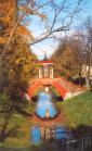
Tavrichesky Garden
TAVRICHESKY GARDEN is a landscape architectural monument located between Shpalernaya Street, Tavricheskaya Street, Kirochnaya Street and Potemkinskaya Street. The total area consists of 21.1 hectares
|
|
|
|
|
hidden
|
Tchaikovskogo Street
Tchaikovskogo STREET, from Fontanka River Embankment to Potemkinskaya Street. The street was laid in the first half of the 18th century and originally called Second Artilleryskaya Street, sometimes also referred as Second Pushkarskaya Street
|
|
|
|
|
hidden
|
Teatralnaya Square
TEATRALNAYA SQUARE, known as Karuselnaya Square until the 1780s, surrounded by Griboedova Canal Embankment, Kryukov Canal Embankment, Dekabristov Street, Glinki Street and Soyuza Pechatnikov Street. The square was built in the 1760s
|
|
|
|
|
hidden
|
Tentelevka, river (Olkhovka)
TENTELEVKA (Olkhovka), a river in the west of St. Petersburg in the area of Nevskaya Zastava, formerly a tributary to the Tarakanovka River. It was named after the village of Tentelevo which was situated in this area in the 18th century; the other
|
|
|
|
|
hidden
|
Three Hundred Anniversary of St. Petersburg Memorial Park
THREE HUNDRED ANNIVERSARY OF ST. PETERSBURG MEMORIAL PARK was laid out in the 1990s in the north-western outskirts of St. Petersburg, in the western part of Staraya Derevnya
|
|
|
|
|
hidden
|
Tikhoretsky Avenue
TIKHORETSKY AVENUE, called Benua Avenue from 1909 to 1952, from Gidrotekhnikov Street to Severny Avenue. The avenue was laid in the early 20th century within the limits of Sosnovka and named after architect Y.Y
|
|
|
|
|
hidden
|
Toponymy of St. Petersburg
TOPONYMY OF ST. PETERSBURG, a corpus of names of geographical points situated on the territory of St. Petersburg. Names of rivers, islands, and villages located on the city's future territory appeared long before its foundation
|
|
|
|
|
hidden
|
Toreza Avenue
TOREZA AVENUE, called Staro-Pargolovsky Avenue until 1964, from Muzhestva Square to the intersection of Engelsa Avenue and Severny Avenue. The avenue was laid in the 18th century and led towards Pargolovo (hence the original name)
|
|
|
|
|
hidden
|
Torfyanoe
TORFYANOE, an area to the north of St. Petersburg, between Pargolovo in the west and Parnas industrial zone in the east. The name comes from a village of the same name that appeared in the late 1920s owing to peat digging developed in this region
|
|
|
|
|
hidden
|
Toriki
TORIKI, an area to the south-west of St. Petersburg, to the west of Gorelovo railway station, along Anninskoe Freeway. In the early 18th century, Konstantinovka village was located on this site
|
|
|
|
|
hidden
|
Traktornaya Street
TRAKTORNAYA STREET, from Stachek Avenue to Sivkov Lane. The street was laid on the place of Krylova Lane and named so in 1926 in commemoration of the output of the first tractors at the Krasny Putilovets plant (present-day Kirov Plant)
|
|
|
|
|
hidden
|
Troitskaya Square
TROITSKAYA SQUARE, called Kommuny Square from 1918 to 1923, then known as Revolyutsii Square until 1991, between Kamennoostrovsky Avenue and Kuybysheva Street. The square appeared in the early 18th century on Gorodskoy (present-day Petrogradsky)
|
|
|
|
|
hidden
|
Troitskoe Field
TROITSKOE FIELD, an area to the south-east of St. Petersburg, on the left bank of the Neva River, between Obukhovskoy Oborony Avenue, Zaporozhskaya Street, Gribakinykh Street and Babushkina Street. A part of Alexandrovskoe
|
|
|
|
|
hidden
|
Troitsky Avenue
TROITSKY AVENUE, from Izmaylovsky Avenue to Lermontovsky Avenue; the avenue is the extension of First Krasnoarmeyskaya Street. In the late 18th century, the avenue was known as First Street, called Troitskaya Street from the 1830s (Troitsky Avenue)
|
|
|
|
|
hidden
|
Troitsky Island
TROITSKY ISLAND (Trinity Island) used to bear the name Petrogradsky Island, along with the name of Gorodskoy Island in the first third of the 18th century. After, it was renamed after the Holy Trinity and St. Peter's Cathedral.
Е. А
|
|
|
|
|
hidden
|
Truda Square
TRUDA SQUARE, known as Blagoveshchenskaya Street from the 1830s to the 1880s, then called Blagoveshchenskaya Square until 1918. The square is surrounded by Angliiskaya Embankment, Konnogvardeysky Boulevard
|
|
|
|
|
hidden
|
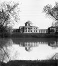
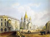
Tsarskoe Selo, palace and park ensemble
TSARSKOE SELO (Pushkin town), a monument of town-planning and a palace and park ensemble dating from the 18th to the beginning of the 20th century. The core of the ensemble is the estate of Empress Catherine I Sarskaya Myza (founded in 1710)
|
|
|
|
|
hidden
|
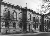
Tsentralny (Central) District
TSENTRALNY (CENTRAL) DISTRICT, an administrative-territorial entity within St. Petersburg, with the territorial administration situated at 176 Nevsky Prospect. The district was set up in 1994, when Smolninsky District
|
|
|
|
|
hidden
|
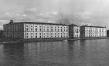
Tuchkov Buyan
TUCHKOV BUYAN (1a Bolshoy Avenue of the Petrogradskaya Side), an architectural monument in the style of Early Classicism, consisting of a set of hemp storehouses, which include three stone structures
|
|
|
|
|