hidden
|
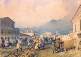
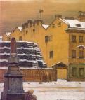
Kolokolnaya Street
KOLOKOLNAYA STREET, located between Vladimirsky Avenue and Marata Street. Constructed in the 1740s according to a project by the St. Petersburg Construction Commission
|
|
|
|
|
hidden
|
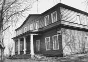
Kolomenskaya Street
KOLOMENSKAYA STREET, located between Kuznechny Lane and Volokolamsky Lane. The road was constructed in the 1740s, according to a project by the St. Petersburg Construction Commission
|
|
|
|
|
hidden
|
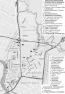
Kolomensky Island
KOLOMENSKY ISLAND, historical name of the area between the Moika River, Kryukov Canal, Griboedova Canal, Fontanka River, Bolshaya Neva River, and Pryazhka River. Its area is over 90 hectares
|
|
|
|
|
hidden
|
Kolomna
KOLOMNA, a historical district in the west part of St. Petersburg, between the Bolshaya Neva, Moika, Fontanka and Kryukov Canal. The name appeared in the early 18th century, most likely, on account of working people from the town of Kolomna
|
|
|
|
|
hidden
|
Kolomyagi
KOLOMYAGI, an area to the north-west of St. Petersburg, north of the Komendantsky Aerodrome and south-west of Ozerki; in the west it is adjacent large-scale residential development of Ozero Dolgoe
|
|
|
|
|
hidden
|
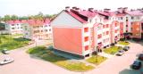
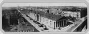
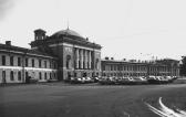
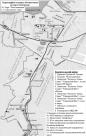
Kolpino town
KOLPINO, a town, the centre of Kolpinsky District of St. Petersburg (since 1936), a station of Oktyabrskaya railway, 26 km to the south-east of St. Petersburg. It occupies the total area of 66 square km. The population is 142,800 people (2000)
|
|
|
|
|
hidden
|
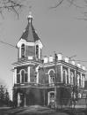
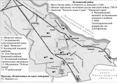
Kolpinsky District
KOLPINSKY DISTRICT, an administrative and territorial unit of Saint Petersburg (with the territorial administration situated in Kolpino, at 1 Uritskogo Street). The name derives from the town of Kolpino which is the centre of the district
|
|
|
|
|
hidden
|
Koltovskie, locality
KOLTOVSKIE, historical name of a region in the western part of Petrogradsky Island between Pionerskaya Street (former Bolshaya Koltovskaya Street), Bolshaya Zelenina Street
|
|
|
|
|
hidden
|
Koltushi Hills
KOLTUSHI HILLS, a height east of St. Petersburg within the boundaries of Neva Lowland. It is a group of kame hills with a height of 60.5 to 78.3 meters above the reclaimed swampy piedmonts at the elevation of 25-35 meters formed along the
|
|
|
|
|
hidden
|
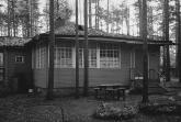
Komarovo, village
KOMAROVO (until 1948 Kellomaki), the former settlement (since 1946), a municipal unit forming a part of Kurortny District of St. Petersburg (since 1997), 40 km to the north-west of the city
|
|
|
|
|
hidden
|
Komendantsky Aerodrome
KOMENDANTSKY AERODROME, an area in the north-west of St. Petersburg, between Kolomyazhsky Avenue, Parashyutnaya Street, Sizova Street and Chernaya Rechka river
|
|
|
|
|
hidden
|
Komsomolskaya Square
KOMSOMOLSKAYA SQUARE, at the intersection of Stachek Avenue and Krasnoputilovskaya Street. Constructed in the 1950s in the course of the development of the Avtovo District, according to a plan designed by architect A.A. Ol in the 1930s
|
|
|
|
|
hidden
|
Kondratyevsky Avenue
KONDRATYEVSKY AVENUE (from the 1830s to 1918, Bezborodkinsky Avenue), located between Arsenalnaya Street and Mechnikova Avenue. It was built in the second half of the 18th century
|
|
|
|
|
hidden
|
Konnogvardeysky Boulevard
KONNOGVARDEYSKY BOULEVARD (in 1918-91, Profsoyuzov Boulevard), located between Dekabristov Square, St. Isaac's Square and Truda Square. The Admiralty Canal was excavated along Konnogvardeysky Boulevard in the early 18th century for transporting wood
|
|
|
|
|
hidden
|
Konyushennaya Square
KONYUSHENNAYA SQUARE is located between Konyushenny Lane and Griboedova Canal, and was laid out beginning in the 1720s and over the course of the Stables Department's construction of its buildings complex (house No 1, 1720-23, architect N. F
|
|
|
|
|
hidden
|
Korolenko Street
KOROLENKO STREET (known until 1921 as Baskova Street, its owner"s name), is located between Nekrasova Street and Preobrazhenskaya Square. Laid out in the second half of the 18th century, it was renamed after V. G
|
|
|
|
|
hidden
|
Kosmonavtov Avenue
KOSMONAVTOV AVENUE is located between Kuznetsovskaya Street and Svirskaya Street, running across the Alexandrovskaya Settlement and Srednyaya Rogatka. Laid out in the 1960s and named in honour of Soviet cosmonauts
|
|
|
|
|
hidden
|
Kosygina Avenue
KOSYGINA AVENUE (in 1976-82 Ladozhsky Avenue), located between the junction of the Oktyabrskaya Railway Line and Kommuny Street. It was built in the 1970s as an extension of Zanevsky Avenue, and named after A.N. Kosygin
|
|
|
|
|
hidden
|
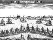
Kotlin, Island
KOTLIN, is an island in the east of the Neva Bay, in the Gulf of Finland. It is 23 kilometres west of Vasilievsky Island, 12 kilometres southwest of Gorskaya, and six kilometres north of Lomonosov
|
|
|
|
|
hidden
|
Krasnenkaya, river
KRASNENKAYA, a river in the south-west of St. Petersburg, flowing through Avtovo District and Yugo-Zapad District. The name of the river dates back to 1773, when it was known as Krasnaya Rechka
|
|
|
|
|
hidden
|
Krasnoarmeiskie Streets, First - Thirteenth
KRASNOARMEISKAYA STREETS, FIRST - THIRTEENTH (until 1923, the First - Twelfth Roty, and Zarotnaya Street). First - Seventh Krasnoarmeiskaya Streets are located between Moskovsky Avenue and Izmailovsky Avenue; Eighth Krasnoarmeiskaya Street
|
|
|
|
|
hidden
|
Krasnoe Selo, area
KRASNOE SELO, a town; since 1973, it formed a part of Krasnoselsky District of Leningrad; since 1997 - municipal unit; 26 km to the south-west of St. Petersburg centre, on Narva federal motorway. A railway station on the line St
|
|
|
|
|
hidden
|
Krasnogo Kursanta Street
KRASNOGO KURSANTA STREET (until 1923, Bolshaya Spasskaya Street), located between Bolshoy Avenue of the Petrogradskaya Side and Novoladozhskaya Street. Appeared in the 1720s, in what was then the Nevsky Garrison Regiment settlement (until 1727
|
|
|
|
|
hidden
|
Krasnogvardeysky District
KRASNOGVARDEYSKY DISTRICT is an administrative territorial unit of St. Petersburg. (Its territory administration is located at 52 Sredneokhtinsky Avenue). It was established in 1973. It was named in honour of the Petrograd Red Guards
|
|
|
|
|
hidden
|
Krasnoputilovskaya Street
KRASNOPUTILOVSKAYA STREET, running from Komsomolskaya Square to Pobedy Square, passing through the Avtovo area, the former Vologodskaya-Yamskaya Settlement, the Alexandrovskaya Settlement, and Srednaya Rogatka
|
|
|
|
|
hidden
|
Krasnoselsky District
KRASNOSELSKY DISTRICT is an administrative territorial unit of St. Petersburg. (Its territory administration is located at 3 Partizana Germana Street) Its present day borders were established in 1973. It was named after the town of Krasnoe Selo
|
|
|
|
|
hidden
|
Krasny Canal
KRASNY CANAL (Red Canal) was built between the Moika River and the Bolshaya Neva River in 1711 to drain the territory. It passed approximately along the western part of the Field of Mars
|
|
|
|
|
hidden
|
Krasnye Zori
KRASNYE ZORI, a locality in the East of Petrodvortsovy District between Strelna and New Peterhof, also a railway platform along the Baltiyskaya Railway Line. The name derives from Krasnye Zori labour settlement school
|
|
|
|
|
hidden
|
Krestovka, river
KRESTOVKA, a river in the north-west of St. Petersburg, a channel from Malaya Nevka to Srednyaya Nevka. The river separates Kamenny Island and Krestovsky Island. It is 0
|
|
|
|
|
hidden
|
Krestovsky Island
KRESTOVSKY ISLAND (Cross Island), situated between the Srednaya Nevka River separating it from Elagin Island, the Malaya Nevka River separating it from Petrovsky Island, Petrogradsky Island, Aptekarsky Island
|
|
|
|
|