hidden
|
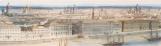
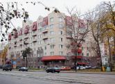
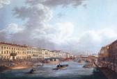
Dvortsovaya Embankment
DVORTSOVAYA EMBANKMENT (Palace Embankment), called Verkhnaya Naberezhnaya Street or First Verkhnaya Embankment beginning in 1738; in the 1740s-90s, it was known as Millionnaya Embankment; from 1923 to 1944 it was called Devyatogo Yanvarya Embankment
|
|
|
|
|
hidden
|
Dyuny (Dunes), area
DYUNY (Dunes), an area in the north part of Sestroretsk, on the coast of the Gulf of Finland. The name is conditioned by the terrain structure: sand-dunes covered with a pine forest
|
|
|
|
|
hidden
|
Dyuny, Forest Park
DYUNY, a Forest Park, spreading out along the coast of the Gulf of Finland forming a strip of approximately 13 by 3-4 km between the northern outskirts of Sertroretsk and Solnechnoe village
|
|
|
|
|
hidden
|
Dzhambula Lane
DZHAMBULA LANE, running between the Fontanka River Embankment and Zagorodny Avenue. Known as Leshtukov (Lestokov) Lane until 1952. The lane was laid in the first half of the 18th century
|
|
|
|
|
hidden
|
Earthern Dams
EARTHERN DAMS, zones within the territory of St. Petersburg with an artificially raised level. From the very first days of the city development bedding was used for the low spots to protect it from water, especially floods
|
|
|
|
|
hidden
|
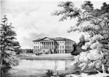
Ekaterinhof
EKATERINHOF, a country estate. Tsar Peter the Great presented it to his wife Ekaterina Alexeevna (the future Empress Catherine I) in 1711. It was situated on Ekaterinhofsky Island
|
|
|
|
|
hidden
|
Ekaterinhofka, river
EKATERINHOFKA, a river in the west of St. Petersburg. Originally called Chernaya Rechka, while its present name refers to the Ekaterinhof Palace. The river is a lateral channel of the Bolshaya Neva River: starting from the mouth of the latter and
|
|
|
|
|
hidden
|
Ekaterinhofsky Island
EKATERINHOFSKY ISLAND washed by the Ekaterinhofka River, Tarakanovka River, and Bumazhny Canal. It is 40 hectares in area and 700 metres long and wide. The island formed after Bumazhny Canal was built in the second half of the 18th century
|
|
|
|
|
|
hidden
|
hidden
|
Embankments (entry)
EMBANKMENTS, engineering works built along the waterways of St. Petersburg from the early 18th century in order to stabilise banks and reclaim land. The first wooden embankments appeared in Gorodskoy Island on the left bank of the Neva River between
|
|
|
|
|
hidden
|
Emelyanovka, river
EMELYANOVKA, a river to the south-west of St. Petersburg, in Avtovo. Its name has been known since 1772; it probably originates from the name of a landowner. The headwaters of the river used to be 1 kilometre westwards of the intersection of
|
|
|
|
|
hidden
|
Energetikov Avenue
ENERGETIKOV AVENUE, from Carl Faberge Avenue to Marshala Blucher Avenue. The avenue was laid in the 1960s as a part of the central ring route. It was built during the 1960s-80s
|
|
|
|
|
hidden
|
Engelsa Avenue
ENGELSA AVENUE, a part of Vyborgskoe Freeway until 1918, running from Novosiltsevsky Lane past Third Verkhny Lane; the avenue is an extension of Bolshoy Sampsonievsky Avenue. The avenue was called so in honour of German socialist F. Engels (1820-95)
|
|
|
|
|
hidden
|
English Park (Peterhof)
ENGLISH PARK is situated in the west part of Peterhof, in the lower course of Shinkarka River, to the north of Egerskaya Settlement and to the northwest of Lugovoy Park. Stary Petergof railway station is situated at its southwest outskirts
|
|
|
|
|
hidden
|
Entuziastov Avenue
ENTUZIASTOV AVENUE, from Peredovikov Street to Kommuny Street, in the area of Rzhevka - Porokhovye. The avenue was laid in the 1960s as a part of the central semicircular thoroughfare
|
|
|
|
|
hidden
|
Farforovskaya Street
FARFOROVSKAYA STREET, a street running from Obukhovskoy Oborony Avenue to Sedova Street. Laid out in the second half of the 19th century and given the name Bolshaya Shchemilovka Street after the cognominal Shchemilovka township
|
|
|
|
|
hidden
|
Five Corners
FIVE CORNERS, a traditional informal name of the crossroads, formed by Zagorodny Avenue, Lomonosova Street (former Chernyshev Lane), Rubinstein Street (former Troitskaya Street) and Razyezzhaya Street. Appeared in the 1760s
|
|
|
|
|
hidden
|
Floods
FLOODS. Raises of water over 160 centimetres above the zero-level of Kronstadt Tide-gauge or over 150 centimetres above the zero water level of the Neva River (the water post is located near the Mining Institute)
|
|
|
|
|
hidden
|
Fonarny Lane
FONARNY LANE, between the Moika River Embankment and Griboedova Canal. The lane was laid in the 1730s and named Golitsyn Lane in 1739, after the last name of a house-owner, Prince M. Golitsyn
|
|
|
|
|
hidden
|
Fontanka, river
FONTANKA (known as Bezymyanny Erik until 1712-14), river, a branch in the Neva river delta, which crosses the central part of the city. The river flows from the Neva on the left, beside the Summer Garden
|
|
|
|
|
hidden
|
Forest Parks Green Belt
FOREST PARKS GREEN BELT is situated 20-60 km from the centre of St. Petersburg and includes forest parks and forests of the city and adjacent regions of Leningrad Region
|
|
|
|
|
hidden
|
Frunzensky District
FRUNZENSKY DISTRICT, an administrative and territorial unit of St. Petersburg, with its administration located at 46 Prazhskaya Street. Formed in 1936, it was named in honour of Soviet statesman and military commander M. V
|
|
|
|
|
hidden
|
Furshtatskaya Street
FURSHTATSKAYA STREET, from Liteiny Avenue to Potemkinskaya Street. The street was laid in the 18th century next to Liteiny Court and named Third Artilleryskaya Street, to adopt the name Furshtatskaya (Furshtadtskaya) Street in 1806 only
|
|
|
|
|
hidden
|
Galernaya Street
GALERNAYA STREET, runs from Dekabristov Square to Novo-Admiralteysky Canal Embankment crossing Truda Square. In 1738, it was known as Isaakievskaya Street (after St
|
|
|
|
|
hidden
|
Galerny Island
GALERNY ISLAND, (Galley Island), situated at the mouth of the Fontanka River about ten hectares in area. The island was extended to the north by narrowing the right branch of the Fontanka River in the late 18th century
|
|
|
|
|
hidden
|
Galley Harbour
GALLEY HARBOUR is an engineering monument from the early 18th century. A rectangular pool located in the western part of Vasilievsky Island in the 18th - early 19th centuries served as a base for naval rowing vessels (galleys, hence the name)
|
|
|
|
|
hidden
|
Gatchina, town
GATCHINA (in 1923-1927 Trotsk, in 1927-1944 Krasnogvardeisk), a town in Leningrad Region, 45 km to the south from St. Petersburg. Known since 1499 as Khotchino village, since the early 18th century - the Gatchinskaya farm-stead
|
|
|
|
|
hidden
|
Geological location
GEOLOGICAL LOCATION. St. Petersburg along with its outskirts is located on the convergence of two major tectonic structures: the southern Baltic Plate and the Northwest Russiаn Plate of the East European plain
|
|
|
|
|
hidden
|
Glukharka, river
GLUKHARKA, a river in the north-west of St. Petersburg. It used to flow off from the marshes situated west of Dolgoe lake. In the course of the building up of adjacent territory
|
|
|
|
|
hidden
|
Glukhoe Lake
GLUKHOYE LAKE, 1) located between Navalochnaya and Farforovskaya railway stations of the Moscow Line of Oktyabrskaya Railroad. Originally, Glukhoye Lake was 0.8 km long and wide
|
|
|
|
|