hidden
|
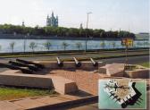
Novo-Izmailovsky Avenue
NOVOIZMAILOVSKY AVENUE between Blagodatnaya Street and Konstitutsii Square. It was laid close to the former Korpusnoe Highway in the same direction as one of the three radial roads - Voznesensky Avenue and Izmailovsky Avenue (hence the name
|
|
|
|
|
hidden
|
Novo-Kovalevo
NOVO-KOVALEVO, a locality in the far east of St. Petersburg southwards from Post Kovalevo Railway Station of Vsevolozhskoe direction. The name is derived from a former settlement which in 1973 was incorporated within Krasnogvardeysky District of
|
|
|
|
|
hidden
|
Novo-Orlovsky Forest Park
NOVO-ORLOVSKY FOREST PARK is located in the north of St. Petersburg in Kolomyagi, west from Ozerki. The total area of the park is 144 hectares. The park was laid out in 1955 on the area of natural forests. The Kamenka River runs through it
|
|
|
|
|
hidden
|
Novosmolenskaya Embankment
NOVOSMOLENSKAYA EMBANKMENT known as Oktyabrskaya Embankment in 1976-87 and Smolenka River Embankment in 1987-89. It was laid downstream the Smolenka River along both banks of the straightened riverbed between Nalichnaya Street and Morskaya
|
|
|
|
|
hidden
|
Novy Port
NOVY PORT (New Port), a locality in the northern part of Gutuevsky Island. The name appeared in the late 19th century after the relocation of the Morskoy Trade Port
|
|
|
|
|
hidden
|
Nyenschantz
NYENSCHANTZ (the Swedish name for a fortification on the Neva; called Kantsy in Russian). A Swedish fortress and the town Nyen on the cape at the confluence of the Okhta River and the Neva River
|
|
|
|
|
hidden
|
Obukhovo
OBUKHOVO, a landmark in southwest of Saint Petersburg, between Sofiyskaya Street, Alexandrovskoy Fermy Avenue, the Moskovskaya railway line and the Yuzhnoe railway semi-circle
|
|
|
|
|
hidden
|
Obukhovskoy Oborony Avenue
OBUKHOVSKOY OBORONY AVENUE from Alexandra Nevskogo Square to Karavaevskaya Street. It was laid in the early 18th century as a road to Arkhangelsk through Shlisselburg and was known as Shlisselburgskaya Road, Shlyutenburgskaya Road
|
|
|
|
|
hidden
|
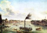
Obvodny Canal
OBVODNY CANAL flows from the Neva River in the area of Alexander Nevsky Lavra to the Ekaterinhofka River (8.08 km long, 21.3 meters wide and 42.6 meters wide in its eastern part)
|
|
|
|
|
hidden
|
Okhta, river
OKHTA (from Finnish word meaning "bear; pertaining to a bear"), a river in the east of St. Petersburg, the largest tributary to the Neva River within the limits of the city
|
|
|
|
|
hidden
|
Okhtinsky Razliv
OKHTINSKY RAZLIV is an artificial reservoir constructed after the building of the dike at the Okhta River in the area of the Powder Factory in the 19th century. Its lake-shaped bed width is about 5 km long, 250 meters wide and up to 4 meters deep
|
|
|
|
|
hidden
|
Okkervil, river
OKKERVIL, a river in the north-east of St. Petersburg, a left tributary to the Okhta River, which flows into the latter 1.8 kilometres above the mouth of the Okhta
|
|
|
|
|
hidden
|
Oktyabrskaya Embankment
OKTYABRSKAYA EMBANKMENT translated as October Embankment and known as Pravogo Berega Nevy Embankment before 1973. It runs between Zolnaya Street and Novosaratovka Settlement and crosses a number of settlements such as Klochki
|
|
|
|
|
hidden
|
Old Peterhof
OLD PETERHOF, the name of a part of Petrodvorets west of the Angliisky Park; also a railway station along the Saint Petersburg-Lomonosov line. In the 1970-80s, an academic training facility and one of Saint Petersburg State University's campuses
|
|
|
|
|
hidden
|
Olgino, settlement
OLGINO, a summer cottage village 15 kilometres northwest of Saint Petersburg, on the northern coast of the Gulf of Finland, in the vicinity of a cognominal railway platform
|
|
|
|
|
hidden
|
Olympia, the Garden
OLYMPIA, is a garden in the centre of St. Petersburg, on Moskovsky Avenue, between Klinsky Avenue, Malodetskoselsky Avenue and Bataisky Lane. The total area of Olimpiya is 2.7 hectares. It was laid out on the location of Klinsky Market in 1946-47
|
|
|
|
|
hidden
|
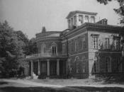
Oranienbaum, palace and park ensemble
ORANIENBAUM, a palace and park ensemble (Lomonosov town) that started to form during the first quarter of the 18th century, when the country estate of A.D. Menshikov appeared on the coast of the Gulf of Finland 44 kilometres from St. Petersburg
|
|
|
|
|
hidden
|
Orlovsky Park (Strelna)
ORLOVSKY PARK is a landscape park following English traditions. It was laid out in the first half of the 19th century (architect P. S. Sadovnikov) in the estate of Count A. F. Orlov in Strelna
|
|
|
|
|
hidden
|
Osinovaya Roshcha (Aspen Grove)
OSINOVAYA ROSHCHA (Aspen Grove), a former settlement north of Pargolovo at the junction of the Vyborgskoe and Priozerskoe Highways. First records of Osinovaya Roshcha trace back to the late18th century
|
|
|
|
|
hidden
|
Osinovaya Roshcha, the Park
OSINOVAYA ROSHCHA (Aspen Grove) is a park in the village of the same name. It is located two kilometres to the north-east of Levashovo Railway Station. Osinovaya Roshcha is an architectural landscape monument of the end of the 18th - beginning of
|
|
|
|
|
hidden
|
Ostrova, area
OSTROVA (Islands), general unofficial name of Elagin Island, Krestovsky Island and Kamenny Island (see articles), that was common in the 19th - early 20th centuries. In 1934-92, these islands were renamed Kirovskie (after S.M. Kirov)
|
|
|
|
|
hidden
|
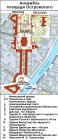
Ostrovskogo Square
OSTROVSKOGO SQUARE known as Alexandrinskaya Square before 1923, between Nevsky Prospect and Zodchego Rossi Street. It was renamed after playwright A. N. Ostrovsky (1823-86). The square was designed by architect K. I
|
|
|
|
|
hidden
|
Ozerki, locality
OZERKI, a locality in the northern part of Saint Petersburg, neighbouring Shuvalovo on the north, the Novo-Orlovsky forest park on the northwest, the Udelnaya metro station on the south, and Kolomyagi on the southwest
|
|
|
|
|
hidden
|
Palace Square
PALACE SQUARE, St. Petersburg's main square, the traditional location for city-wide festivities, and is part of the central square system of the Neva River's left bank
|
|
|
|
|
hidden
|
Paradiz
PARADIZ (from French рaradis - "paradise"), an unofficial name, Tsar Peter the Great used for St. Petersburg in his correspondence with members of the family and friends starting from 1705.
Reference: Письма и бумаги императора Петра Великого
|
|
|
|
|
hidden
|
Pargolovo
PARGOLOVO, a former settlement; since 1997, a municipal unit along the Vyborgskoe Highway, in the Vyborgsлy District of Saint Petersburg; also, a train station. As of 2002, the population count was approximately 4,000 people
|
|
|
|
|
hidden
|
Pargolovo Hills
PARGOLOVO HILLS, a natural prominence in the south of St. Petersburg. It received its name from a Finish village of Parkola (later called Pargolovo) that was once situated in the surroundings
|
|
|
|
|
hidden
|
Parks (entry)
PARKS are monuments of landscape architecture located in various landscape environments. There are parks located on the lower and on the upper terraces of the Gulf of Finland (the parks of Petrodvorets and Lomonosov)
|
|
|
|
|
hidden
|
Parnas
PARNAS, an industrial and warehouse area to the north of Suzdalsky Avenue and junction railway line Ruchyi - Pargolovo. The overbridge on Kultury Avenue connects it with residential districts of St. Petersburg
|
|
|
|
|
hidden
|
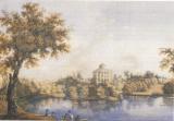
Pavlovsk, Palace and Park Ensemble
PAVLOVSK, the palace and park ensemble in the town Pavlovsk, is one of the biggest landscape parks in Europe. Its total area is 600 hectares. In 1777, the estate located here was presented by Empress Catherine II to her son Prince Pavel Pavlovich on
|
|
|
|
|