hidden
|
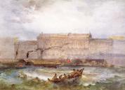
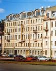
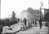
Admiralteiskaya Embankment
ADMIRALTEISKAYA EMBANKMENT, in 1918-44 - Roshalya Embankment in honour of revolutionary S. G. Roshal (1896-1917), lying between Dvortsovy Avenue and Dekabristov Square
|
|
|
|
|
hidden
|
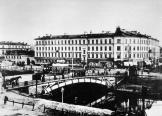
Admiralty Canal
ADMIRALTY CANAL was dug from the eastern ditch of the Amiralty Fortress (today, the Dvortsovy Bridge ramp to the Palace Square) to the Moika River to connect the Admiralty Shipyard with Galerny Dvor (Galley Yard) and warehouses of New Holland
|
|
|
|
|
hidden
|
Angliiskaya Embankment
ANGLIISKAYA EMBANKMENT, from 1738 - Beregovaya Nizhnaya Embankment Street, in the mid-to-late 18th century - Isaakievskaya Embankment, Galernaya Embankment, and Anglinskaya Embankment, from 1800s - Angliiskaya Embankment
|
|
|
|
|
hidden
|
Arsenalnaya Embankment
ARSENALNAYA EMBANKMENT on the right bank of the Neva River between Arsenalnaya Street and Akademika Lebedeva Street. It was so named in 1887 after Novy Arsenal Plant (today, Arsenal Joint-Stock Company situated in house 1)
|
|
|
|
|
hidden
|
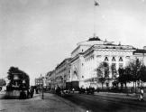
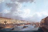
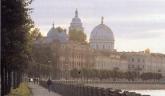
Dvortsovaya Embankment
DVORTSOVAYA EMBANKMENT (Palace Embankment), called Verkhnaya Naberezhnaya Street or First Verkhnaya Embankment beginning in 1738; in the 1740s-90s, it was known as Millionnaya Embankment; from 1923 to 1944 it was called Devyatogo Yanvarya Embankment
|
|
|
|
|
hidden
|
Embankments (entry)
EMBANKMENTS, engineering works built along the waterways of St. Petersburg from the early 18th century in order to stabilise banks and reclaim land. The first wooden embankments appeared in Gorodskoy Island on the left bank of the Neva River between
|
|
|
|
|
hidden
|
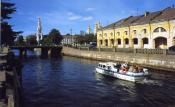
Fontanka, river
FONTANKA (known as Bezymyanny Erik until 1712-14), river, a branch in the Neva river delta, which crosses the central part of the city. The river flows from the Neva on the left, beside the Summer Garden
|
|
|
|
|
hidden
|
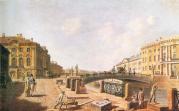
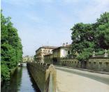
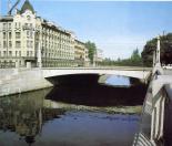
Griboyedova Canal
GRIBOYEDOVA CANAL (the Ekaterininsky Canal in 1767-1923) starts from the Moika River at the Field of Mars and flows into the Fontanka River at Malo-Kalinkin Bridge. It is 5 km long and 32 meters wide with water flow of 3.1 - 3.4 m3
|
|
|
|
|
hidden
|
Karpovka, river
KARPOVKA (from Fin. Korpijoki, which means Forest River or Crow River), a river, separating Petrogradsky Island and Aptekarsky Island. The river is 3 kilometres long
|
|
|
|
|
hidden
|
Kronverkskaya Embankment
KRONVERKSKAYA EMBANKMENT is located between Troitskaya Square and Kronverksky Avenue along the right bank of Kronverksky Strait. It was laid in 1980 and received its name after Kronverk at the same time
|
|
|
|
|
hidden
|
Kryukov Canal
KRYUKOV CANAL runs from the Admiralty Canal by Truda Square to the Fontanka River. 1015 meters long, it was dug from the Neva River to the Moika River in 1719-20 and was named after the contractor Semen Kyukov in 1738 (the section from the Neva to
|
|
|
|
|
hidden
|
Kutuzova Embankment
KUTUZOVA EMBANKMENT, located on the left bank of the Neva River, running from Liteiny Avenue to the Fontanka River Embankment. In the 18th - first half of the 19th centuries, it formed a part of the Dvortsovaya Embankment; from 1860
|
|
|
|
|
hidden
|
Lieutenant Schmidt Embankment
LIEUTENANT SCHMIDT EMBANKMENT (until 1887, the Bolshaya Neva Embankment; until 1918, the Nikolaevskaya Embankment), on the right bank of the Bolshaya Neva River, between Seventh Line and Twenty Third Line of Vasilievsky Island. Named after P.P
|
|
|
|
|
hidden
|
Makarova Embankment
MAKAROVA EMBANKMENT (until 1887 - Malaya Neva River Embankment, until 1952 - Tuchkova Embankment), between Birzhevaya Square and Smolenka River Embankment, on Vasilievsky Island, on the left bank of the Malaya Neva. The embankment was named after S
|
|
|
|
|
hidden
|
Moika, river
MOIKA (the original name Mya; known as Muya until the early 18th century, derived from the Izhora word for "slush, mire"), a river in the Neva river delta. The Moika River is 4.67 kilometres long, with a width of up to 40 metres
|
|
|
|
|
hidden
|
Morskaya Embankment
MORSKAYA EMBANKMENT goes along the aggraded shore of the Gulf of Finland from the square in front of the Pribaltiyskaya Hotel to Nalichnaya Street (the name was given in 1972)
|
|
|
|
|
hidden
|
Mytninskaya Embankment
MYTNINSKAYA EMBANKMENT stretching from Kronverksky Avenue to Dobrolyubova Avenue along Kronverksky Channel and the Malaya Neva River in the southern extremity of Petrogradsky Island at the approach of Birzhevoy Bridge
|
|
|
|
|
hidden
|
Novo-Admralty Canal
NOVO-ADMIRALTY CANAL (New Admiralty Canal) flowing from the confluence of the Moika River and the Admiraly Canal to the Bolshaya Neva was dug in the first quarter of the 18th century
|
|
|
|
|
hidden
|
Novosmolenskaya Embankment
NOVOSMOLENSKAYA EMBANKMENT known as Oktyabrskaya Embankment in 1976-87 and Smolenka River Embankment in 1987-89. It was laid downstream the Smolenka River along both banks of the straightened riverbed between Nalichnaya Street and Morskaya
|
|
|
|
|
hidden
|
Obvodny Canal
OBVODNY CANAL flows from the Neva River in the area of Alexander Nevsky Lavra to the Ekaterinhofka River (8.08 km long, 21.3 meters wide and 42.6 meters wide in its eastern part)
|
|
|
|
|
hidden
|
Oktyabrskaya Embankment
OKTYABRSKAYA EMBANKMENT translated as October Embankment and known as Pravogo Berega Nevy Embankment before 1973. It runs between Zolnaya Street and Novosaratovka Settlement and crosses a number of settlements such as Klochki
|
|
|
|
|
hidden
|
Pesochnaya Embankment
PESOCHNAYA EMBANKMENT situated on Aptekarsky Island between Kamennoostrovsky Avenue and Karpovka River Embankment. It was laid on the left bank of the Malaya Nevka River in 1820s and named Pesochnaya Embankment (Sand Embankment) because of the sandy
|
|
|
|
|
hidden
|
Petrogradskaya Embankment
PETROGRADSKAYA EMBANKMENT known as Peterburgskaya Embankment until 1914. It lies between Petrovskaya Embankment and Karpovka River Embankment on the left bank of the Neva River in the east of Petrogradsky Island (hence the name)
|
|
|
|
|
hidden
|
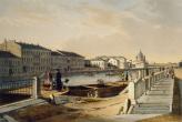
Petrovskaya Embankment
PETROVSKAYA EMBANKMENT lying between Troitskaya Square and Petrogradskaya Embankment on the right bank of the Neva River on Petrogradskaya Side. It appeared in what was then the city centre in the 1700s as the first embankment of St. Petersburg
|
|
|
|
|
hidden
|
Pirogovskaya Embankment
PIROGOVSKAYA EMBANKMENT on the right bank of the Bolshaya Nevka River between Akademika Lebedeva Street and Maly Sampsonievsky Avenue. It consists of two sections. The first section, named after N. I
|
|
|
|
|
hidden
|
Pryazhka, river
PRYAZHKA, a river, flowing from the Moika River into Salnobuyansky Canal and on into the Neva River. The river is 1.32 kilometres long. Banny Bridge, Matisov Bridge and Berdov Bridge were span Pryazhka River
|
|
|
|
|
hidden
|
Robespierre Embankment
ROBESPIERRE EMBANKMENT (in 1887-1916 Voskresenskaya Embankment, after the Holy Resurrection Church; until 1923 Belgiiskaya Embankment), on the left bank of the Neva River, between Smolnaya Embankment and Liteiny Avenue
|
|
|
|
|
hidden
|
Shkipersky Canal
SHKIPERSKY CANAL (Skippers' Canal) (before 1859, Chernaya Rechka (the Black River) or Glukhoy Protok (the Dead Canal), a small river in the western part of Vasilievsky Island
|
|
|
|
|
hidden
|
Sinopskaya Embankment
SINOPSKAYA EMBANKMENT, on the left bank of the Neva River, from Smolny Avenue to Alexandra Nevskogo Square. In the first half of the 18th century, it was called Naberezhnaya Street or Nevskaya Rozhdestvenskaya Embankment
|
|
|
|
|
hidden
|
Smolenka, river
SMOLENKA, a river, which branches off the Malaya Neva from the left, below Tuchkov Bridge, and flows into the Neva Bay of the Gulf of Finland. The Smolenka separates Vasilievsky Island from Dekabristov Island. The river is 3.3 kilometres long
|
|
|
|
|