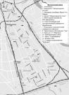
Addresses
/
Ligovsky Ave/Saint Petersburg, city
hidden
|
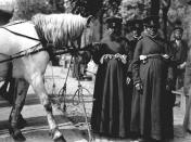
Cabmen
CABMEN, appeared in St. Petersburg in the city's early days (decree of 1705 "On Taxing Cabmen"), at about the same time cab driving grew into a business practised as a rule by peasants. By 1745 there were 3,000 cabmen in St. Petersburg
|
|
|
|
|
hidden
|
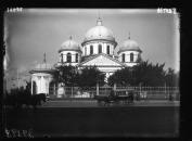
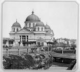
Church of the Holy Sign
CHURCH OF THE HOLY SIGN in Tsarskoe Selo (2a Sadovaya Street, Pushkin), an architectural monument in the Baroque style of the reign of Anna Ioannovna. It was built according to the plans of architect M. G. Zemtsov with the assistance of I. Y
|
|
|
|
|
hidden
|
Dostoevskogo Street
DOSTOEVSKOGO STREET, running from Kuznechny Lane to Sotsialisticheskaya Street. In 1739-99, the main part of the street was called Skatertnaya; the length extending from Svechnoy Lane to Ruzovskaya Street bore the name Semenovskaya Street (after the
|
|
|
|
|
hidden
|
Embankments (entry)
EMBANKMENTS, engineering works built along the waterways of St. Petersburg from the early 18th century in order to stabilise banks and reclaim land. The first wooden embankments appeared in Gorodskoy Island on the left bank of the Neva River between
|
|
|
|
|
hidden
|
Frunzensky District
FRUNZENSKY DISTRICT, an administrative and territorial unit of St. Petersburg, with its administration located at 46 Prazhskaya Street. Formed in 1936, it was named in honour of Soviet statesman and military commander M. V
|
|
|
|
|
hidden
|
Kuznechny Lane
KUZNECHNY LANE, connects Zagorodny Avenue and Vladimirskaya Square with Ligovsky Avenue. In the 1740s, this territory was settled by blacksmiths serving the court. In the 1760s, the Church of Our Lady of Vladimir was erected along the street
|
|
|
|
|
hidden
|
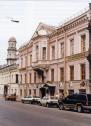
Ligovsky Avenue
IGOVSKY AVENUE, running between Nekrasova Street and Moskovsky Avenue. Known as Ligovskaya Street until 1956. Constructed along the Ligovsky Canal track (hence the name) starting in 1891
|
|
|
|
|
hidden
|
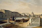
Ligovsky Canal
LIGOVSKY CANAL was constructed to supply drinking water to St. Petersburg under the project of Grigory Skornyakov-Pisarev in 1718-21. Originally, it was 23 km long, 2-4 meters bottom-wide and 1-2 meters deep
|
|
|
|
|
hidden
|
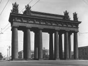
Moscow Triumphal Arch
MOSCOW TRIUMPHAL ARCH built in 1834-38, designed by architect V.P. Stasov, stands on the intersection of Moskovsky Avenue and Ligovsky Avenue in commemoration of the Russian military victories in the Russo-Turkish War of 1828-29
|
|
|
|
|
hidden
|
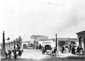
Moskovskaya Zastava
MOSKOVSKAYA ZASTAVA, the historical name of the north part of present-day Moskovsky District. The name originates from the post that existed at the intersection of Moscow road and Ligovsky Canal
|
|
|
|
|
hidden
|
Nicholas II, the Emperor (1868-1918)
Nicholas II (1868, Tsarskoe Selo - 1918), Emperor from 1894 to 1917. Son of Emperor Alexander III and Empress Maria Fedorovna. Married Princess of Hesse-Darmstadt, who took the name of Alexandra Fedorovna
|
|
|
|
|
hidden
|
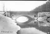
Novo-Kamenny Bridge
NOVO-KAMENNY BRIDGE (also known as Vodoprovodny; Yamskoy, after Yamskaya Sloboda; Bolshoy Karetny; Granitny), over Obvodny Canal, at Ligovsky Avenue. The bridge was built in 1817-21 (engineer P.P
|
|
|
|
|
hidden
|
Peski
PESKI (sands), the historical name of the area in the centre of St. Petersburg, between the Neva River, Nevsky Prospect and Ligovsky Avenue, on both sides of Suvorovsky Avenue. The name is caused by the nature of the ground
|
|
|
|
|
hidden
|
Prudki, garden
PRUDKI is a garden in the central part of St. Petersburg, between Ligovsky Avenue, Grechesky Avenue, Nekrasova Street and Prudkovsky Lane. The garden was laid out on the spot of the former ponds which existed at the end of Ligovsky Canal
|
|
|
|
|
hidden
|
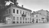
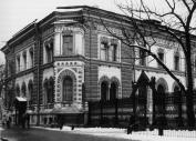
Rachau K.K., (1830-1880), architect
RACHAU Karl Karlovich (1830 - 1880, St. Petersburg), architect, one of the prominent representatives of St. Petersburg Eclectism, master of interiors, accentuating small forms and an architectural scholar
|
|
|
|
|
hidden
|
Razyezzhaya Street
RAZYEZZHAYA STREET (in the first half of the 19th century, it was also referred to as Chernyshev Lane), between Zagorodny Avenue and Ligovsky Avenue. The road was named in 1739, constructed in the 1740s following the designs of St
|
|
|
|
|
hidden
|
Relief
RELIEF. Despite having a general plain character, its flatness and large built up areas, the relief of St. Petersburg is diverse and full of contrasts. The highest peaks in the southwest of the city reach 176 meters
|
|
|
|
|
hidden
|
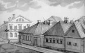
Settlements(entry)
SETTLEMENTS (sloboda), St. Petersburg settlements set on separate territories and featuring homogeneous social structure. The population of a settlement is united by occupation, estate, parentage or religion
|
|
|
|
|
hidden
|
Sovetskie Streets, First - Tenth
SOVETSKIE STREETS, First - Tenth (were called Rozhdestvenskie Streets from 1798 to 1923, after the Nativity of Our Lord Church, with the present-day name given on occasion of the 6th anniversary of the October Revolution of 1917)
|
|
|
|
|
hidden
|
Srednyaya Rogatka
SREDNYAYA ROGATKA, the historical name of the area where Pulkovskoe Freeway and Moskovskoe Freeway intersect. In the 18th-19th centuries, an outpost was located there and the road was blocked with rogatka (turnpike) at night (hence the name)
|
|
|
|
|
hidden
|
Tsentralny (Central) District
TSENTRALNY (CENTRAL) DISTRICT, an administrative-territorial entity within St. Petersburg, with the territorial administration situated at 176 Nevsky Prospect. The district was set up in 1994, when Smolninsky District
|
|
|
|
|
hidden
|
Vosstaniya Square
VOSSTANIYA SQUARE (translated as Uprising Square) known as Znamenskaya Square until 1918 lies at the intersection of Nevsky Prospect and Ligovsky Avenue. The first name translated as Holy Sign Square originated from the Holy Sign Church
|
|
|
|
|
hidden
|
Zastavy (Outposts) (entry)
ZASTAVY (OUTPOSTS), checkpoints, established in the early 18th century on the main roads at the entrance to St. Petersburg to check goods, luggage and to register people, leaving or entering the city
|
|
|
|
|
hidden
|
Zhukovskogo Street
ZHUKOVSKOGO STREET, running from Liteiny Avenue to Ligovsky Avenue. Previously known as Malaya Italyanskaya Street, the street assumed its present-day name in 1902 in commemoration of the 50th anniversary of the death of V.A. Zhukovsky
|
|
|
|
|