hidden
|
Volkovsky Canal
VOLKOVSKY CANAL, built in the late 1960s during the development of the district of Kupchino along the railway embankment of Vitebskaya Railroad. The canal derives its name from the Volkovka River
|
|
|
|
|
hidden
|
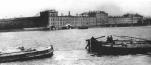
Volny Island
VOLNY ISLAND, name of two now defunct islands. 1) Volny Island at the mouth of the Malaya Neva River where the coasts watch post was situated until the early 20th century. It was linked to Dekabristov Island after deposition of soil in 1960s
|
|
|
|
|
hidden
|
Volodarsky, village
VOLODARSKY VILLAGE (until 1918 - Alexandrovsky village), an area 18 km south-west from the centre of St. Petersburg. Volkhonskoe Freeway joins it with Strelna and Pushkin, while Krasnoselskoe Freeway connects it with Krasnoe Selo
|
|
|
|
|
hidden
|
Volynkina Village
VOLYNKINA, formerly a village, situated by the Ekateringofka River in the area of the intersection of present-day Kalinina Street and Trefoleva Street. From the 15th century, this place was the site of the Finnish village of Vallakula
|
|
|
|
|
hidden
|
Voronya Mountain
VORONYA MOUNTAIN, a peak to the south of St. Petersburg in the vicinity of Krasnoe Selo village, one of the highest points of the Duderhof Heights (147 meters above the sea level); it overlooks the surroundings with the elevation of approximately
|
|
|
|
|
hidden
|
Voskresensky Canal
VOSKRESENSKY CANAL (The Inzhenernaya Channel) was dug during the construction of Mikhailovsky Castle along its southern facade in 1797-1800. It flew from the Fontanka River through the ponds of Mikhailovsky Garden and drained into the Moika River
|
|
|
|
|
hidden
|
Vosstaniya Square
VOSSTANIYA SQUARE (translated as Uprising Square) known as Znamenskaya Square until 1918 lies at the intersection of Nevsky Prospect and Ligovsky Avenue. The first name translated as Holy Sign Square originated from the Holy Sign Church
|
|
|
|
|
hidden
|
Vosstaniya Street
VOSSTANIYA STREET known as Znamenskaya (Holy Sign) Street until 1923, named after the Holy Sign Church. The street runs between Nevsky Prospect and Kirochnaya Street. The present-day name is in memory of the February Revolution of 1917
|
|
|
|
|
hidden
|
Votic Fifth
VOTIC FIFTH (Vodskaya Pyatina), one of five administrative-territorial entities of Novgorod Land, which were subdivided into principalities, regions and districts
|
|
|
|
|
hidden
|
Vozdukhoplavatelny Park
VOZDUKHOPLAVATELNY PARK (Aerostatic Park), the historical name of the territory to the south-west of Volkovaya Village, near the railway station of the same name
|
|
|
|
|
hidden
|
Voznesensky Avenue
VOZNESENSKY AVENUE, translated as Ascension Avenue, between Admiralteisky Avenue and Fontanka River Embankment. It was laid in the early 18th century. It runs towards the tower of the Main Admiralty and crosses St Isaac’s Square
|
|
|
|
|
hidden
|
Vvedenskaya Street
VVEDENSKAYA STREET, from Bolshoy Avenue of Petrogradskaya Side to Kronverksky Avenue. The street was known as Second Vvedenskaya Street in the 1730s-90s; from 1923 to 1944 it was called Rozy Luxemburg Street
|
|
|
|
|
hidden
|
Vvedensky Canal
VVEDENSKY CANAL was dug between the Obvodny Canal and the Fontanka River in 1807-10. It received its name from Vvedensky Cathedral (Presentation of the Holy Virgin Cathedral) (at different times it was named Soyedinitelny (Connecting), Novy (New)
|
|
|
|
|
hidden
|
Vyazemsky Garden
VYAZEMSKY GARDEN is situated on the Aptekarsky Island, on the left bank of Malaya Nevka River, at the corner of Pesochnaya Embankment and Vyazemsky Lane. It was laid out in the first half of the 19th century around Princes Vyazemsky estate (hence
|
|
|
|
|
hidden
|
Vyborgskaya Embankment
VYBORGSKAYA EMBANKMENT on the right bank of the Bolshaya Nevka River between Maly Sampsonievsky Avenue and Chernaya Rechka Embankment. The name originated from Vyborgskaya Side in 1887
|
|
|
|
|
hidden
|
Vyborgskaya Side
VYBORGSKAYA SIDE, a historical district of St. Petersburg, on the right bank of the Neva River and the Bolshaya Nevka River. In the east, it is confined by the Chernaya Rechka River
|
|
|
|
|
hidden
|
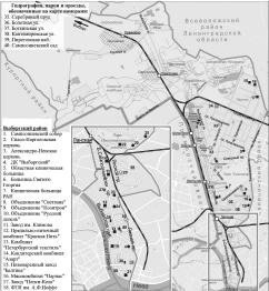
Vyborgsky District
VYBORGSKY DISTRICT is an administrative territorial unit of St. Petersburg. (Its territory administration is located at 86 Bolshoy Sampsonievsky Avenue) The district was founded in 1917; and its present-day territorial borders were established in
|
|
|
|
|
hidden
|
White Nights
WHITE NIGHTS, the name of a natural phenomenon connected with the high geographic latitude of the region, the city is situated at latitude of 59.5 degrees north
|
|
|
|
|
hidden
|
Wildlife
WILDLIFE. The St. Petersburg region’s fauna includes about 60 mammal species, up to 250 bird species, a considerable number of amphibians and reptilians, as well as plentiful invertebrates such as worms, insects, etc
|
|
|
|
|
hidden
|
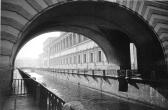
Winter Canal
WINTER CANAL was dug from the Palace Embankment to the Moika river embankment by the contractor V. Ozerov (228 meters long, about 20 meters wide, average waterflow of 2m3/s) in 1718-19
|
|
|
|
|
hidden
|
Yablonovka
YABLONOVKA, an area close to Ladozhskaya metro station, on the right bank of the Okkervil River. Since 1817, it was known as Bolshaya Yablonka village (since 1831 - Bolshaya Yablonovka). Malaya Yablonovka village was located about 1 km up-stream
|
|
|
|
|
hidden
|
Yakornaya Square
YAKORNAYA SQUARE in Kronstadt, the central square of the town, limited by the ravine of Petrovsky Dock, the wall of the Admiralty and Obvodny Canal. The square appeared in 1754 as the place for the storage of anchors and anchor chains (hence the
|
|
|
|
|
hidden
|
Yakubovicha Street
YAKUBOVICHA STREET, called Novo-Isaakievskaya Street until 1923, after St. Isaac's Cathedral, running between Isaakievskaya Square and Truda Square. The street was named after Decembrist A.I. Yakubovich (1792-1845)
|
|
|
|
|
hidden
|
Yuntolovskaya Forest Dacha
YUNTOLOVSKAYA FOREST DACHA is a reserve in Primorsky District of St. Petersburg with the total area of approximately 2,000 hectares. It is bordered by the Yuntolovka River and the Kamenka River flowing into the Lake Lakhtinsky Razliv and the fields
|
|
|
|
|
hidden
|
Yury Gagarin Avenue
YURY GAGARIN AVENUE, between Blagodatnaya Street and Moskovskoe Freeway. From the 1910s to 1961 the avenue bore the name Narymsky Avenue, after the village of Narym in Tomskaya Region
|
|
|
|
|
hidden
|
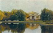
Yusupovsky Garden
YUSUPOVSKY GARDEN (Yusupov Garden) was laid out in the 1790s on the territory of the estate of Prince B. G. Yusupov on the section between the Fontanka River and the Sadovaya Street. The total area is 4.3 hectares
|
|
|
|
|
hidden
|
Yuzhno-Primorsky Park
YUZHNO-PRIMORSKY PARK is surrounded by the Peterhof Highway to the South and Doblesti Street to the East and faces towards the Gulf of Finland to the north-west and north. The total area is 58 hectares
|
|
|
|
|
hidden
|
Zagorodny Avenue
ZAGORODNY AVENUE, running from Vladimirskaya Square to Moskovsky Avenue. The avenue was laid in the 1740s according to a project planned by the Commission for the Building of St
|
|
|
|
|
hidden
|
Zakharyevskaya Street
ZAKHARYEVSKAYA STREET, running from Liteiny Avenue to Potemkinskaya Street. The street was laid in the first third of the 18th century, in the area surrounding Liteiny Yard
|
|
|
|
|
hidden
|
Zanevsky Avenue
ZANEVSKY AVENUE, located on the right bank of the Neva River, extends from Malookhtinsky Avenue to Soedinitelnaya Railway Line, running through Malaya Okhta and Yablonevka
|
|
|
|
|