Entries
/
Tobacco Factories (entry)
hidden
|
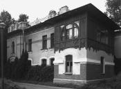
Lermontovsky Avenue
LERMONTOVSKY AVENUE, running between Dekabristov Street and Obvodny Canal Embankment. Formed in 1912 as part of the joining of Bolshaya Masterskaya Street (from Dekabristov Street to Griboedova Canal)
|
|
|
|
|
hidden
|
Lesnaya Harbour
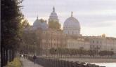
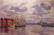
LESNAYA HARBOUR (Forest Harbour) is a complex of artificial water constructions including several rectangular cuts located in the southern part of Gutuyevsky Island
|
|
|
|
|
hidden
|
Lesnoy
LESNOY, a historical district in the north of St. Petersburg, between Engelsa Avenue to the west, Manchesterskaya Street to the north, Thoreza Avenue and Karbysheva Street to the east and Novorossiiskaya Street to the south
|
|
|
|
|
hidden
|
Lesnoy Avenue
LESNOY AVENUE, from Akademika Lebedeva Street to Institutsky Lane, joining the Finlyandsky Railway Station with the Lesnoy District. The street was laid in the 19th century; until 1913, the avenue
|
|
|
|
|
hidden
|
Levashovo, settlement
LEVASHOVO, a former settlement, north-west of the city centre; since 1997, a municipal unit of the Vyborgsky District of Saint Petersburg. It emerged as a settlement for workers building the Vyborg railway station in 1870
|
|
|
|
|
hidden
|
Levashovskaya Pustosh
LEVASHOVSKAYA PUSTOSH, a tract of land in the vicinity of the Levashovo Railway Station (135 Gorskoe Highway), one of the cemeteries for political victims born in Leningrad
|
|
|
|
|
hidden
|
Lieutenant Schmidt Embankment
LIEUTENANT SCHMIDT EMBANKMENT (until 1887, the Bolshaya Neva Embankment; until 1918, the Nikolaevskaya Embankment), on the right bank of the Bolshaya Neva River, between Seventh Line and Twenty Third Line of Vasilievsky Island. Named after P.P
|
|
|
|
|
hidden
|
Ligovo, village
LIGOVO, a historical district in the south-west of St. Petersburg, between Peterhofskoye Highway, Marshala Zhukova Avenue, Baltiiskaya Railway Line and the Ivanovka River
|
|
|
|
|
hidden
|
Ligovsky Avenue
IGOVSKY AVENUE, running between Nekrasova Street and Moskovsky Avenue. Known as Ligovskaya Street until 1956. Constructed along the Ligovsky Canal track (hence the name) starting in 1891
|
|
|
|
|
hidden
|
Ligovsky Canal
LIGOVSKY CANAL was constructed to supply drinking water to St. Petersburg under the project of Grigory Skornyakov-Pisarev in 1718-21. Originally, it was 23 km long, 2-4 meters bottom-wide and 1-2 meters deep
|
|
|
|
|
hidden
|
Lines of Vasilievsky Island (entry)
LINES Of VASILIEVSKY ISLAND, the historical name of a number of parallel streets that intersect Vasilievsky Island from the south to the north: First to Twenty-Ninth Lines, Birzhevaya Line, Kozhevennaya Line, Kosaya Line, Mendeleevskaya Line
|
|
|
|
|
hidden
|
Lisy Nos, settlement
LISY NOS, a settlement on the northern coast of the Gulf of Finland; municipal unit of the Primorsky Administrative District, former urban settlement (from 1948); also the name of a train station 25 kilometres away from Saint Petersburg
|
|
|
|
|
hidden
|
Liteiny Avenue
LITEINY AVENUE [in 1918-44 - Volodarskogo Avenue, after revolutionary V. Volodarsky (1891-1918)], between Liteiny Bridge and Nevsky Prospect. In 1711, a foundry was founded at the beginning of future Liteiny Avenue; later, houses of craftsmen
|
|
|
|
|
hidden
|
Lomonosov, town
LOMONOSOV (until 1948 Oranienbaum), a town and municipal unit within Saint Petersburg, the centre of Lomonosovsky District of the Leningrad Region, located 32 kilometres southwest of the city centre on the southern coast of the Gulf of Finland
|
|
|
|
|
hidden
|
Lomonosova Square
LOMONOSOVA SQUARE (until 1948 - Chernysheva Square), between Zodchego Rossi Street and Fontanka River Embankment. It was named after M.V. Lomonosov (the first name was given after Count I.G. Chernyshev). The road was built in 1828
|
|
|
|
|
hidden
|
Lomonosova Street
LOMONOSOVA STREET, from Griboedova Canal Embankment to "Five Corners". The street was constructed in the first third of the 18th century. Since 1739, the lot before the Fontanka River was called Chernyshev Lane (after the manor of Count I.G
|
|
|
|
|
hidden
|
Lomonosovskaya Harbour (the city of Lomonosov)
LOMONOSOVSKAYA HARBOUR is a natural gulf located on the southern shore of the Gulf of Finland in the northern part of the city of Lomonosov (hence, the name) at the head of the Karasta River. It cuts inland for almost 0
|
|
|
|
|
hidden
|
Lomonosovsky District
LOMONOSOVSKY DISTRICT, an administrative and territorial unit of St. Petersburg, with its administration located in the town of Lomonosov, at 42 Dvortsovy Avenue
|
|
|
|
|
hidden
|
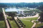
Lower Park (Petrodvorets)
LOWER PARK forms the main part of the Peterhof Palace and Park Ensemble, located on an area adjacent to the Gulf of Finland which is actually lower than sea level, hence its name. The total area of the park is 102
|
|
|
|
|
hidden
|
Lubya, river
LUBYA, a river in the north-east of St. Petersburg, in the area of Rzhevka and Porokhovye. The river is also known as Luppa (a distorted version of Izhora word lupyu which means a river littered with timber)
|
|
|
|
|
hidden
|
Makarova Embankment
MAKAROVA EMBANKMENT (until 1887 - Malaya Neva River Embankment, until 1952 - Tuchkova Embankment), between Birzhevaya Square and Smolenka River Embankment, on Vasilievsky Island, on the left bank of the Malaya Neva. The embankment was named after S
|
|
|
|
|
hidden
|
Malaya Konyushennaya Street
MALAYA KONYUSHENNAYA STREET (in the 18th century Rozhdestvenskaya Street, in 1918-91 Sofia Perovskaya Street), located between Nevsky Prospect and Shvedsky Lane, laid out in the 1760s as a passageway to the Court Stables (hence the name)
|
|
|
|
|
hidden
|
Malaya Neva
MALAYA NEVA, the second largest (after Bolshaya Neva) branch of the Neva river delta. The Malaya Neva separates from the Neva near the Spit of Vasilievsky Island and flows into the Neva Bay between Dekabristov Island and Petrovsky Island
|
|
|
|
|
hidden
|
Malaya Nevka
MALAYA NEVKA, a branch of the Neva river delta, which splits off from the Bolshaya Nevka near the Spit of Kamenny Island. The river flows into the Neva Bay between Krestovsky Island and Petrovsky Island, converging with the Malaya Neva
|
|
|
|
|
hidden
|
Malaya Okhta, locality
MALAYA OKHTA, a locality in the eastern part of St. Petersburg, situated on the left bank of the Neva River, above the mouth of the Okhta River. It borders on Soedinitelnaya Railway Line in the north and the Okkervil River in the north-east
|
|
|
|
|
hidden
|
Malinovka
MALINOVKA, formerly a village, located in the northeast of St. Petersburg; known from the late 18th century. It stretched at the place where two rivers of the same name converge (sometimes called Narvin Brook) and the Okhta River (at the
|
|
|
|
|
hidden
|
Maly Avenue of Petrogradskaya Side
MALY AVENUE Of PETROGRADSKAYA SIDE [in the 1770s - Malaya Perspektiva, in 1941-91 - Shchorsa Avenue, after N.A. Shchors a participant of the Civil War (1895-1919)], from Zhdanovskaya Embankment to Shevchenko Square and Kamennoostrovsky Avenue
|
|
|
|
|
hidden
|
Maly Avenue of Vasilievsky Island
MALY AVENUE Of VASILIEVSKY ISLAND [in the 1730-70s - Third Prospektivaya Street, in the 1780-1800s - Malaya Prospektiva, in 1939-44 - Zheleznyakova Avenue, after the participant of October Revolution and Civil War A.G
|
|
|
|
|
hidden
|
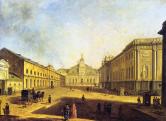
Manezhnaya Square
MANEZHNAYA SQUARE, at the intersection of Italyanskaya Street and Karavannaya Street. It was named in 1866 after the building of Mikhailovsky Manege (1798-1800, architect V.F. Brenna; 1823-24, architect C.I. Rossi )
|
|
|
|
|
hidden
|
Marata Street
MARATA STREET (in the 18th century - Preobrazhenskaya Polkovaya Street, in the first half of the 19th century - Gryaznaya Street, in 1855-1918 - Nikolaevskaya Street after Emperor Nicholas I), between Nevsky Prospect and Podiezdnoy Lane
|
|
|
|
|