hidden
|
Piter
PITER is a colloquial name of St. Petersburg that appeared in the beginning of the 18th century as the abbreviation of the original city's name "Saint Peters-Burgh"
|
|
|
|
|
hidden
|
Platz - Drill Grounds (entry)
PLATZ (from German "Platz" - square) is a large and flat area (squares, waste grounds) for drills and army training. The first platz (drill square) in St. Petersburg was Mars Field
|
|
|
|
|
hidden
|
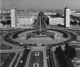
Pobedy Square
POBEDY SQUARE located at the intersection of Moskovsky Avenue, Moskovskoe Freeway, Pulkovskoe Freeway and Krasnoputilovskaya Street, and Ordzhonikidze Street. Until 1962
|
|
|
|
|
hidden
|
Pochtamtskaya Street
POCHTAMTSKAYA STREET, between St. Isaac's Square and Konnogvardeisky Lane. The road was built in the first quarter of the 18th century, in the 1730s it was known as Pushkarskaya Street (after Pushkarskaya, meaning Artillerymen, settlement)
|
|
|
|
|
hidden
|
Podyacheskaya Bolshaya Street
PODYACHESKAYA BOLSHAYA STREET located between Griboedova Canal and the Fontanka River. The name was given in the second half of the 18th century after the occupation of its residents - podyachie (petty officers)
|
|
|
|
|
hidden
|
Podyacheskaya Srednaya Street
PODYACHESKAYA SREDNAYA STREET joins Griboedova Canal Embankment in its bend in the region of its intersection with Rimskogo-Korsakova Avenue. Since 1739 - Prikaznaya Admiralteiskaya Street
|
|
|
|
|
hidden
|
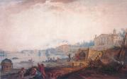
Podzorny Island
PODZORNY ISLAND (Observation Island) is a defunct island that was situated at the mouth of the Fontanka River and was about two hectares in area. It was named after the Observation House situated on the island in the early 18th century
|
|
|
|
|
hidden
|
Poklonnaya Hill
POKLONNAYA HILL, a hill to the north of St. Petersburg at the intersection of the present Engels, Toreza and Severny Avenues, at the southern extremity of the Pargolovo Hills
|
|
|
|
|
hidden
|
Pokrovsky Island
POKROVSKY ISLAND, translated as Intercession Island, area between the Fontanka River, Griboedova Canal, and Kryukov Canal. The area is about 40 hectares. The island was a part of Pervushin Island that also included Kolomensky Island, Kazansky Island
|
|
|
|
|
hidden
|
Polyustrovo
POLYUSTROVO, an area on the right bank of the Neva River, confined with Marshal Blucher Avenue in the north and with Polyustrovsky Avenue and Revolyutsii Freeway in the south, while in the east it is bordered with the railway junction line
|
|
|
|
|
hidden
|
Pontonny, settlement
PONTONNY, a municipal unit within the Kolpinsky District since 1997, between the Neva River and the Bolshaya Izhorka River along the Petrozavodskoe Highway; also a railway station along the Saint Petersburg - Volkhovstroy Line
|
|
|
|
|
hidden
|
Porokhovye
POROKHOVYE, an area in the north-east of St. Petersburg, on the left bank of the Okhta River, between Rzhevka and Malaya Okhta. It encompasses territories of Malinovka and Zhernovka
|
|
|
|
|
hidden
|
Posadskaya Malaya Street
POSADSKAYA MALAYA STREET, on Petrogradskaya Side, between Kamennoostrovsky Avenue and Chapaeva Street. The road appeared in the 1720s in the settlement of craftspeople and tradespeople, transferred to St
|
|
|
|
|
hidden
|
Povarskoy Lane
POVARSKOY LANE (originally called Basmannaya Street; in the 1770s, it was renamed Povarskaya Street, remained as such until the 1790s), between Stremyannaya Street and Kolokolnaya Street. It was built in the 1740s, following the designs of the St
|
|
|
|
|
hidden
|
Predportovaya
PREDPORTOVAYA, a zone with industrial and storage facilities located between Kubinskaya Street, Dunaysky Avenue, Pulkovskoe Highway and Varshavskaya Railway Line
|
|
|
|
|
hidden
|
Primorskoe Freeway
PRIMORSKOE FREEWAY, goes along the shore of the Gulf of Finland (hence the name, that appeared in 1974) through Sestroretsk town and villages of Kurortny District of St. Petersburg
|
|
|
|
|
hidden
|
Primorsky Avenue
PRIMORSKY AVENUE, between Akademika Krylova Street and Savushkina Street, goes along the right bank of the Neva River, through Staraya Derevnya and Novaya Derevnya to Lake Lakhtinsky Razliv, extends Ushakovskaya Embankment
|
|
|
|
|
hidden
|
Primorsky District
PRIMORSKY DISTRICT, an administrative and territorial unit of St. Petersburg, with its administration located at 83 Savushkina Street. Formed in 1936, known as Zhdanovsky District in 1949-89, and existing in its present day boundaries since 1973
|
|
|
|
|
hidden
|
Primorsky Park of Victory
PRIMORSKY PARK OF VICTORY is located on Krestovsky Island. The total area of the park is 168 hectares. Primorsky Park was laid out according to the designs of architect A. S
|
|
|
|
|
hidden
|
Professora Popova Street
PROFESSORA POPOVA STREET (in the 1810s - Pesochny Avenue, from the middle of the 19th century to 1940 - Pesochnaya Street), between Aptekarskaya Embankment and Pesochnaya Embankment, on Aptekarsky Island
|
|
|
|
|
hidden
|
Proletarskoy Diktatury Square
PROLETARSKOY DIKTATURY SQUARE (until 1864 - Orlovskaya Square, in 1864-1918 - Lafonskaya Square, in 1918-52 - Diktatury Square), between Suvorovsky Avenue, Proletarskoy Diktatury Street and Tverskaya Street
|
|
|
|
|
hidden
|
Prosveshcheniya Avenue
PROSVESHCHENIYA AVENUE, between Vyborgskoe Freeway and Rustaveli Street. It goes through First Pargolovo, Shuvalovo - Ozerki, Ruchyi, the main thoroughfare of an extensive area of newly-constructed buildings. The name has been in use since 1970
|
|
|
|
|
hidden
|
Prudki, garden
PRUDKI is a garden in the central part of St. Petersburg, between Ligovsky Avenue, Grechesky Avenue, Nekrasova Street and Prudkovsky Lane. The garden was laid out on the spot of the former ponds which existed at the end of Ligovsky Canal
|
|
|
|
|
hidden
|
Pryazhka, river
PRYAZHKA, a river, flowing from the Moika River into Salnobuyansky Canal and on into the Neva River. The river is 1.32 kilometres long. Banny Bridge, Matisov Bridge and Berdov Bridge were span Pryazhka River
|
|
|
|
|
hidden
|
Pulkovo area
PULKOVO, an area in the south of St. Petersburg, at the junction of Kievskoe Freeway and the road from the town of Pushkin. It is located on Pulkovo heights. Since the 15th century
|
|
|
|
|
hidden
|
Pulkovo Meridian
PULKOVO MERIDIAN, a conventional line passing from the north to the south of St. Petersburg through the telescope of the Central Pulkovo Observatory Building. it deviates 30 degrees and 19
|
|
|
|
|
hidden
|
Pulkovskiye Heights
PULKOVSKIYE HEIGHTS, a natural prominence to the south of St. Petersburg, which received its name from the village of Pulkovo that once existed in the vicinity
|
|
|
|
|
hidden
|
Pulkovskoe Freeway
PULKOVSKOE FREEWAY (until 1974, Kievskoe Freeway), from Pobedy Square to the city boundary, forms a continuation of Moskovsky Avenue, goes along the line of Pulkovsky meridian and closes on the dome of the Pulkovo Observatory
|
|
|
|
|
hidden
|
Pushkarskaya Bolshaya Street
PUSHKARSKAYA BOLSHAYA STREET (until 1798 - Malaya Ofitserskaya Street), between Syezzhinskaya Street and Kamennoostrovsky Avenue, on Petrogradskaya Side. The road appeared in the first third of the 18th century
|
|
|
|
|
hidden
|
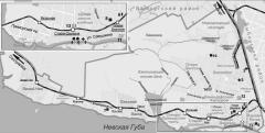
Pushkin, town
PUSHKIN, a town and municipal unit situated south of Saint Petersburg. Known until 1918 as Tsarskoe Selo, and in 1918-37 as Detskoe Selo. As of 2002, population totalled approximately 95,000 inhabitants
|
|
|
|
|