hidden
|
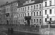
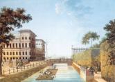
Admiralty Canal
ADMIRALTY CANAL was dug from the eastern ditch of the Amiralty Fortress (today, the Dvortsovy Bridge ramp to the Palace Square) to the Moika River to connect the Admiralty Shipyard with Galerny Dvor (Galley Yard) and warehouses of New Holland
|
|
|
|
|
hidden
|
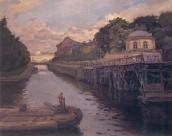
Bumazhny Canal
Bumazhny Canal (Paper Canal) was dug between the Ekaterinhofka River and the Tarakanovka River for practical purposes in the second half of the 18th century. It bears its name from the Ekaterinhof Cotton Mill (today
|
|
|
|
|
hidden
|
Canals (entry)
CANALS are artificial waterways built from the time of St. Petersburg's founding to drain low and swamp lands and create convenient access to ship construction materials and other cargoes (Peter the Great’s wish to create "a second Venice" another
|
|
|
|
|
hidden
|
Canals of Galley Yard
CANALS OF THE GALLEY YARD were dug at the beginning of the 18th century in the western end of Admiralty Island, at the place of the Galley Yard. In 1711 and 1716
|
|
|
|
|
hidden
|
Dudergofsky Canal
DUDERHOFSKY CANAL was built during the improvement of the Peterhof Highway and Southern Primorsky Park. It was named after the Duderhofka River (the Canal covers the river's mouth)
|
|
|
|
|
hidden
|
Grebnoy Canal
GREBNOY CANAL (Rowing Canal) is located in the northern part of Krestovsky Island in Primorsky Victory Park at the place of the former Vinnovka River. In 1938, the Grebnoy Canal was projected to be 2 km in length and run from the head of the
|
|
|
|
|
hidden
|
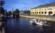
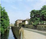
Griboyedova Canal
GRIBOYEDOVA CANAL (the Ekaterininsky Canal in 1767-1923) starts from the Moika River at the Field of Mars and flows into the Fontanka River at Malo-Kalinkin Bridge. It is 5 km long and 32 meters wide with water flow of 3.1 - 3.4 m3
|
|
|
|
|
hidden
|
Kamenny Island Canals
KAMENNY ISLAND CANALS were built in the 18-19th centuries and intended to drain the territory, transport construction materials to palaces and estates and lay out park elements. The canal routes were repeatedly changed
|
|
|
|
|
hidden
|
Krasny Canal
KRASNY CANAL (Red Canal) was built between the Moika River and the Bolshaya Neva River in 1711 to drain the territory. It passed approximately along the western part of the Field of Mars
|
|
|
|
|
hidden
|
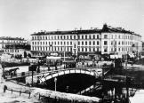
Kryukov Canal
KRYUKOV CANAL runs from the Admiralty Canal by Truda Square to the Fontanka River. 1015 meters long, it was dug from the Neva River to the Moika River in 1719-20 and was named after the contractor Semen Kyukov in 1738 (the section from the Neva to
|
|
|
|
|
hidden
|
Lebyazhy Canal
Lebyazhy Canal (the Swan Canal) was dug from the Bolshaya Neva River to the Moika River between the Field of Mars and Summer Garden in 1711-19. In 1778, the Canal received its name from swans that lived there and in adjacent ponds (in particular
|
|
|
|
|
hidden
|
Ligovsky Canal
LIGOVSKY CANAL was constructed to supply drinking water to St. Petersburg under the project of Grigory Skornyakov-Pisarev in 1718-21. Originally, it was 23 km long, 2-4 meters bottom-wide and 1-2 meters deep
|
|
|
|
|
hidden
|
Maslobuyansky Canal
MASLOBUYANSKY CANAL (the Maslyany (Oil) Canal, the Maslyany Buyan Ditch) was constructed in the southeast Vasilievsky Island in the middle of the 18th century. It was named after the now non-existent Maslyany Buyan
|
|
|
|
|
hidden
|
Matisov Canal
MATISOV CANAL is located in the southwest of St. Petersburg westwards from Yuzhno-Primorsky Park. The canal was excavated in the second half of the 20th century in the left bank lows of Duderhof Canal amidst swampy surrounding of Neva Lowland
|
|
|
|
|
hidden
|
Morskoy Canal
MORSKOY CANAL (the Naval Canal) was constructed along shallow waters of Neva Bay between Gutuyevsky and Kanonersky Islands in 1874-85. The Canal has materially changed the islands' shape
|
|
|
|
|
hidden
|
Novo-Admralty Canal
NOVO-ADMIRALTY CANAL (New Admiralty Canal) flowing from the confluence of the Moika River and the Admiraly Canal to the Bolshaya Neva was dug in the first quarter of the 18th century
|
|
|
|
|
hidden
|
Obvodny Canal
OBVODNY CANAL flows from the Neva River in the area of Alexander Nevsky Lavra to the Ekaterinhofka River (8.08 km long, 21.3 meters wide and 42.6 meters wide in its eastern part)
|
|
|
|
|
hidden
|
Salnobuyansky Canal
SALNOBUYANSKY CANAL was dug between the Korabelnaya Embankment of the Bolshaya Neva River and the Pryazhka River in 1804. It separated Matisov Island from Kolomensky Island
|
|
|
|
|
hidden
|
Samsonovsky Canal
SAMSONOVSKY CANAL (Samsonovsky Pipeline), an artificial hydraulic construction, a part of the water supply system of Peterhof fountains and ponds. It starts from Bolshoy Krugly Pond of Meadow (Lake) Park and ends in Colonists Park by Olgin Pond
|
|
|
|
|
hidden
|
Seldyanoy Canal
SELDYANOY CANAL was dug on Gutuyevsky Island from the Ekaterinhofka River in 1827-38 after the catastrophic flood of 1824 (the soil was used to extend the territory). It was 450 meters long with a 200 meters deviation in the middle
|
|
|
|
|
hidden
|
Shkipersky Canal
SHKIPERSKY CANAL, built in the 1720s in the west part of Vasilivsky Island, it was named after skippers' settlement that once existed on this site. The canal joins Galley Harbour and Nevsky Bay (reserved for ship navigation)
|
|
|
|
|
hidden
|
Volga-Baltic Waterway
VOLGA-BALTIC WATERWAY, an artificial hydrotechnical structure in the north-west of Russia, linking the basins of the Neva River with those of the Volga and Northern Dvina
|
|
|
|
|
hidden
|
Volkovsky Canal
VOLKOVSKY CANAL, built in the late 1960s during the development of the district of Kupchino along the railway embankment of Vitebskaya Railroad. The canal derives its name from the Volkovka River
|
|
|
|
|
hidden
|
Voskresensky Canal
VOSKRESENSKY CANAL (The Inzhenernaya Channel) was dug during the construction of Mikhailovsky Castle along its southern facade in 1797-1800. It flew from the Fontanka River through the ponds of Mikhailovsky Garden and drained into the Moika River
|
|
|
|
|
hidden
|
Vvedensky Canal
VVEDENSKY CANAL was dug between the Obvodny Canal and the Fontanka River in 1807-10. It received its name from Vvedensky Cathedral (Presentation of the Holy Virgin Cathedral) (at different times it was named Soyedinitelny (Connecting), Novy (New)
|
|
|
|
|
hidden
|
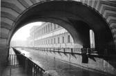
Winter Canal
WINTER CANAL was dug from the Palace Embankment to the Moika river embankment by the contractor V. Ozerov (228 meters long, about 20 meters wide, average waterflow of 2m3/s) in 1718-19
|
|
|
|
|