hidden
|
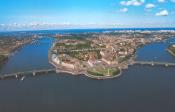
Monastyrsky Island
MONASTYRSKY ISLAND situated between the Neva River, Obvodny Canal and Monastyrka River. It is 50 hectares in area, 900 metres long, and 600 metres wide. The island formed after Obvodny Canal was built in 1832
|
|
|
|
|
hidden
|
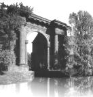
New Holland
NEW HOLLAND (103 Moika River Embankment), a complex of storage facilities situated on the cognominal island (with an area of approximately 3 hectares), appearing in 1720 after the laying out of the Admiralty and Kryukov canals of the Moika River
|
|
|
|
|
hidden
|
Novo-Admiralteysky Island
NOVO-ADMIRALTEYSKY ISLAND, translated as New Admiralty Island, situated between the Bolshaya Neva River, Moika River, and Novo-Admiralteysky Canal. It was a part of Usadishche Island until the early 18th century
|
|
|
|
|
hidden
|
Ostrova, area
OSTROVA (Islands), general unofficial name of Elagin Island, Krestovsky Island and Kamenny Island (see articles), that was common in the 19th - early 20th centuries. In 1934-92, these islands were renamed Kirovskie (after S.M. Kirov)
|
|
|
|
|
hidden
|
Pargolovo Hills
PARGOLOVO HILLS, a natural prominence in the south of St. Petersburg. It received its name from a Finish village of Parkola (later called Pargolovo) that was once situated in the surroundings
|
|
|
|
|
hidden
|
Petrogradsky Island
PETROGRADSKY ISLAND situated between the Neva River, Kronverksky Strait, Malaya Neva River, Zhdanovka River, Malaya Nevka River, Karpovka River, and Bolshaya Nevka River. It is 635 hectares in area, 4.2 kilometres long, and 2.5 kilometres wide
|
|
|
|
|
hidden
|
Petrovsky Island
PETROVSKY ISLAND situated between the Malaya Neva River, Malaya Nevka River, and Zhdanovka River separating it from Petrogradsky Island. It is 120 hectares in area, three kilometres long, and 600 metres wide
|
|
|
|
|
hidden
|
Podzorny Island
PODZORNY ISLAND (Observation Island) is a defunct island that was situated at the mouth of the Fontanka River and was about two hectares in area. It was named after the Observation House situated on the island in the early 18th century
|
|
|
|
|
hidden
|
Poklonnaya Hill
POKLONNAYA HILL, a hill to the north of St. Petersburg at the intersection of the present Engels, Toreza and Severny Avenues, at the southern extremity of the Pargolovo Hills
|
|
|
|
|
hidden
|
Pokrovsky Island
POKROVSKY ISLAND, translated as Intercession Island, area between the Fontanka River, Griboedova Canal, and Kryukov Canal. The area is about 40 hectares. The island was a part of Pervushin Island that also included Kolomensky Island, Kazansky Island
|
|
|
|
|
hidden
|
Pulkovo Meridian
PULKOVO MERIDIAN, a conventional line passing from the north to the south of St. Petersburg through the telescope of the Central Pulkovo Observatory Building. it deviates 30 degrees and 19
|
|
|
|
|
hidden
|
Pulkovskiye Heights
PULKOVSKIYE HEIGHTS, a natural prominence to the south of St. Petersburg, which received its name from the village of Pulkovo that once existed in the vicinity
|
|
|
|
|
hidden
|
Rezvy Maly Island
REZVY MALY ISLAND in the Ekaterinhofka River, downstream the mouth of the Tarakanovka River. It is linked to Gutuevsky Island via a wooden bridge. The island is about two hectares in area, 300 metres long, and 100 metres wide
|
|
|
|
|
hidden
|
Spassky Island
SPASSKY ISLAND, translated as Saviour Island, situated in the centre of St. Petersburg between the Fontanka River, Moika River, Griboedova Canal, and Kryukov Canal. It is over 230 hectares in area
|
|
|
|
|
hidden
|
Troitsky Island
TROITSKY ISLAND (Trinity Island) used to bear the name Petrogradsky Island, along with the name of Gorodskoy Island in the first third of the 18th century. After, it was renamed after the Holy Trinity and St. Peter's Cathedral.
Е. А
|
|
|
|
|
hidden
|
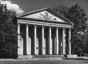
Tuchkov Buyan
TUCHKOV BUYAN (1a Bolshoy Avenue of the Petrogradskaya Side), an architectural monument in the style of Early Classicism, consisting of a set of hemp storehouses, which include three stone structures
|
|
|
|
|
hidden
|
Vasilievsky Island
VASILIEVSKY ISLAND, the largest island in the estuary of the Neva 1,090 hectares in area. The island is washed by the Bolshaya Neva in the south and the Malaya Neva in the northeast
|
|
|
|
|
hidden
|
Volny Island
VOLNY ISLAND, name of two now defunct islands. 1) Volny Island at the mouth of the Malaya Neva River where the coasts watch post was situated until the early 20th century. It was linked to Dekabristov Island after deposition of soil in 1960s
|
|
|
|
|
hidden
|
Voronya Mountain
VORONYA MOUNTAIN, a peak to the south of St. Petersburg in the vicinity of Krasnoe Selo village, one of the highest points of the Duderhof Heights (147 meters above the sea level); it overlooks the surroundings with the elevation of approximately
|
|
|
|
|
hidden
|
Zayachy Island
ZAYACHY ISLAND situated in the broadest part of the Neva. In the north, it is separated from Petrogradsky Island with Kronverksky Strait. The island is 28 hectares in area, 900 metres long, and 500 metres wide
|
|
|
|
|
|
hidden
|