hidden
|
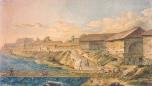
Right Bank of the Neva River
RIGHT BANK OF THE NEVA RIVER, a general name of a vast territory on the right bank of the Neva River southwards from the Soyedinitelnaya railway line and the Okhta - Zanevsky Post stretch
|
|
|
|
|
hidden
|
Rubleviki
RUBLEVIKI, the historical name of an area to the north-east of St. Petersburg, between Bolshaya Okhta, Polyustrovo and Porokhovye. In 1913, a junction line of Finlyandskaya railroad was built through Rubleviki and the railway platform of the same
|
|
|
|
|
hidden
|
Ruchyi
RUCHYI, an area to the north-east of St. Petersburg, to the north of Piskarevka. It was named after a village located on the banks of Murinsky Stream (the site where it intersects present-day Grazhdansky Avenue) from the late 18th century to the
|
|
|
|
|
hidden
|
Rusanovka
RUSANOVKA, an area to the south-east boundary of St. Petersburg, at the end of Oktyabrskaya Embankment, on the site where the Utka River flows into the Neva. The region was named after landlords Rusanov
|
|
|
|
|
hidden
|
Rybatskaya
RYBATSKAYA, a former village, located along the right bank of the Okhta River, four kilometres downstream from the site where the Murinsky Stream flows into the Okhta river
|
|
|
|
|
hidden
|
Rybatskoe, area
RYBATSKOE, an area to the south-east of St. Petersburg, on the left bank of the Neva River, between the Murzinka River and the Slavyanka River. In 1716, Rybnaya (Fish) settlement was founded there at the Peter the Great’s decree
|
|
|
|
|
hidden
|
Rzhevka, area
RZHEVKA, an area in the north-east of St. Petersburg, on the left bank of the Okhta River, to the north-east of Porokhovye. Since the 1730s, the Rzhevskaya Settlement, owned by Captain V.F. Rzhevsky (hence the name), was located there
|
|
|
|
|
hidden
|
Saperny, settlement
SAPERNY, a municipal formation within the Kolpinsky District, far and southeast of Saint Petersburg, between the Neva River and the Saint Petersburg - Volkhovstroy railway line; also a railway station
|
|
|
|
|
hidden
|
Sementsy, area
SEMENTSY, the historical name of the area between Zagorodny Avenue and Obvodny Canal. The name comes from the 18th century settlement of Semenovsky Life Guard Regiment that was quartered on the territory from Zvenigorodskaya Street to Moskovsky
|
|
|
|
|
hidden
|
Settlements(entry)
SETTLEMENTS (sloboda), St. Petersburg settlements set on separate territories and featuring homogeneous social structure. The population of a settlement is united by occupation, estate, parentage or religion
|
|
|
|
|
hidden
|
Shchemilovka
SHCHEMILOVKA, an area to the south-east of St. Petersburg, between Farforovskaya Street, the Neva River, Lesnozavodskaya Street, Krasnykh Zor Boulevard and Sortirovochnaya Station of Moskovskaya Railway Line
|
|
|
|
|
hidden
|
Shushary
SHUSHARY, a municipal unit of Pushkinsky District, 14 kilometres to the south of St. Petersburg, at the intersection of the Russia federal highway and Vitebsk Railway Line (and railway station). The population consists of about 6,000 people (2002)
|
|
|
|
|
hidden
|
Shuvalovo
SHUVALOVO, a locality in the northern part of Saint Petersburg along the banks of Lake Bolshoe (Nizhnee) Suzdalskoe. Shuvalovo is bounded by the Vyborgskoe Highway on the east, adjoining Pargolovo on the north, and Ozerki on the south
|
|
|
|
|
hidden
|
Smolenskoe Field, area
SMOLENSKOE FIELD, the historical name of the area located in the central part of Vasilievsky Island, between Nineteenth Line in the east, Smolenskoe Cemetery (hence the name) in the north and the harbour in the east
|
|
|
|
|
hidden
|
Smolenskoe Village
SMOLENSKOE VILLAGE, a historical region on the left bank of the Neva River, on the territory of Nevskaya Zastava, between Bolshoy Smolensky Avenue and Krupskoy Street
|
|
|
|
|
hidden
|
Sofia
SOFIA, the historical name of the town of Pushkin to the south of Catherine Park, between Pavlovskoe Freeway and Krasnoselskoe Freeway. It was founded in 1785 by Empress Catherine II as a chief town of the district. In 1782-88, St
|
|
|
|
|
hidden
|
Sosnovaya Polyana
SOSNOVAYA POLYANA (Pine Glade), a park to the south-east of St. Petersburg between Veteranov Avenue and Narodnogo Opolchenia Avenue. From the west, it is confined by the Sosnovka River
|
|
|
|
|
hidden
|
Sosnovka (Nevsky District)
SOSNOVKA, the historical name of the area to the south-east of St. Petersburg, between the Neva River, Narodnaya Street and Bolshevikov Avenue. It was named after the manor of A.I
|
|
|
|
|
hidden
|
Sosnovka (Vyborgsky District)
SOSNOVKA, a historical district in the north of St. Petersburg, in the north-east it joins Sosnovka park, in the south-west it is confined with Nauki Avenue, Gzhatskaya Street, Favorskogo Street, Politehnicheskaya Street and Toreza Avenue
|
|
|
|
|
hidden
|
Spassky Gorodensky Principality
SPASSKY GORODENSKY PRINCIPATE was one of the Orekhovsky District's principalities in Votic fifth on the territory of Novgorod. In the 15th -17th centuries, the complete right bank of the Neva (including the Lakhta Region and Nevsky Settlement) and a
|
|
|
|
|
hidden
|
Srednyaya Rogatka
SREDNYAYA ROGATKA, the historical name of the area where Pulkovskoe Freeway and Moskovskoe Freeway intersect. In the 18th-19th centuries, an outpost was located there and the road was blocked with rogatka (turnpike) at night (hence the name)
|
|
|
|
|
hidden
|
Staraya Derevnya
STARAYA DEREVNYA, a historical district in the north-west of St. Petersburg, on the right bank of the Bolshaya Nevka River (opposite Elagin Island), to the west of Novaya Derevnya. In the 18th century, chancellor A. P
|
|
|
|
|
hidden
|
Staropanovo
STAROPANOVO, the former village, located to the south of Ligovo Railway Station, along Tallinskoe Freeway (buildings 60-190). Appeared in the early 19th century (was also-called Maloe Ligovo and Ekaterininskaya)
|
|
|
|
|
hidden
|
Steklyanny Settlement
STEKLYANNY SETTLEMENT (Glass Settlement), an area on the left bank of the Neva River, on the territory of Nevskaya Zastava, between Obvodny Canal in the north and Smolenskoe village in the south. In the 1770s, the territory belonged to G.A
|
|
|
|
|
hidden
|
Strelna
STRELNA, formerly a settlement, a municipal unit within the Petrodvortsovy District since 1997; 19 kilometers southwest of Saint Petersburg, on the southern coast of the Gulf of Finland, where it meets the Strelka River
|
|
|
|
|
hidden
|
Torfyanoe
TORFYANOE, an area to the north of St. Petersburg, between Pargolovo in the west and Parnas industrial zone in the east. The name comes from a village of the same name that appeared in the late 1920s owing to peat digging developed in this region
|
|
|
|
|
hidden
|
Toriki
TORIKI, an area to the south-west of St. Petersburg, to the west of Gorelovo railway station, along Anninskoe Freeway. In the early 18th century, Konstantinovka village was located on this site
|
|
|
|
|
hidden
|
Turukhtannye Islands
TURUKHTANNYE ISLANDS, an area to the south-west of St. Petersburg, in the zone of the coal harbour of the seaport. The name comes from waterlogged islands that existed on this site before the 1930s, but merged with the mainland
|
|
|
|
|
hidden
|
Udelnaya
UDELNAYA, an area in the north part of St. Petersburg; in the north, it adjoins Ozerki, in the east - Sosnovka forest park, in the east - Kolomyagi, in the south-west - Udelny Park
|
|
|
|
|
hidden
|
Ulyanka
ULYANKA, an area to the south-west of St. Petersburg; in the north-east, it borders on Dachnoe (divided from it with Alexandrino forest park); in the west, it is confined with Marshal Zhukov Avenue, in the south - with Narodnogo Opolcheniya Avenue
|
|
|
|
|