hidden
|
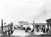
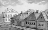
Matrosskaya Sloboda
MATROSSKAYA SLOBODA (Sailors' Settlement), a settlement founded in the early 18th century on the right bank of the Okhta River, opposite the confluence of the Okhta River and Okkervil River
|
|
|
|
|
hidden
|
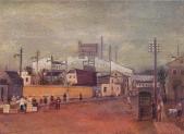
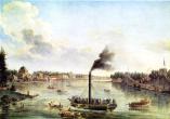
Metallostroy, settlement
METALLOSTROY, an urban settlement within the Kolpinsky District of Saint Petersburg, and a station along the Oktyabrskaya Railway. As of 2001, the population count was 23,700 inhabitants
|
|
|
|
|
hidden
|
Mikhaila Arkhangela Selo
MIKHAILA ARKHANGELA SELO, the historical name of a locality on the Nevskaya Zastava Territory. In the north it bordered on the settlement of Smolenskoe and in the south by the Farforovaya Colony
|
|
|
|
|
hidden
|
Moskovskaya Side
MOSKOVSKAYA Side, the 18th century name of the territory on the left bank of the Neva River to the east and south-east from the Fontanka River, that was populated with labourers, brought from Moscow in the early 18th century (hence the name)
|
|
|
|
|
hidden
|
Moskovskaya Zastava
MOSKOVSKAYA ZASTAVA, the historical name of the north part of present-day Moskovsky District. The name originates from the post that existed at the intersection of Moscow road and Ligovsky Canal
|
|
|
|
|
hidden
|
Murino
MURINO, a rural settlement (and former village) on Toksovskoe Freeway, 0.5 km from the city borders, adjoining the north-east outskirts of St. Petersburg. The Murinsky Stream, railway station in St
|
|
|
|
|
hidden
|
Murzinka, river
MURZINKA, a locality enclosed by Zaporozhskaya Street, the Neva River, the Murzinka River and the railway line linking Obukhovo and Rybatskoe. The name originates from the grange (later to become a village) of Murzinka, which belonged to A.I
|
|
|
|
|
hidden
|
Narvskaya Zastava
NARVSKAYA ZASTAVA, the historical name of the northern part of Kirovsky District. It descends to an outpost on the post road to Narva and Reval (today Tallin), that was located on the place of present-day Stachek Square
|
|
|
|
|
hidden
|
Nevskaya Zastava
NEVSKAYA ZASTAVA (outpost), a historical name of the territory along the left bank of the Neva River from Alexander Nevsky Lavra to Rybatskoe. It encompasses the following historical districts and localities: Steklyanny Settlement (Glass Settlement)
|
|
|
|
|
hidden
|
Nevsky Settlement
NEVSKY SETTLEMENT (in the present-day academic literature, it is also called the Nevsky Estuary), a Russian trade settlement at the confluence of the Okhta River and the Neva River
|
|
|
|
|
hidden
|
New Peterhof
NEW PETERHOF, part of the town of Petrodvorets, west of the Angliisky Park, also the name of a railway station along the Saint Petersburg - Lomonosov line. The Petrodvorets Watch Plant and the Popov Higher Navy School of Radioelectronics are located
|
|
|
|
|
hidden
|
Novaya Derevnya
NOVAYA DEREVNYA, a historical district in the north-west of St. Petersburg, on the right bank of the Bolshaya Nevka River, in the west it borders on Staraya Derevnya, in the east it is confined by the Chernaya Rechka River
|
|
|
|
|
hidden
|
Novo-Kovalevo
NOVO-KOVALEVO, a locality in the far east of St. Petersburg southwards from Post Kovalevo Railway Station of Vsevolozhskoe direction. The name is derived from a former settlement which in 1973 was incorporated within Krasnogvardeysky District of
|
|
|
|
|
hidden
|
Novy Port
NOVY PORT (New Port), a locality in the northern part of Gutuevsky Island. The name appeared in the late 19th century after the relocation of the Morskoy Trade Port
|
|
|
|
|
hidden
|
Nyenschantz
NYENSCHANTZ (the Swedish name for a fortification on the Neva; called Kantsy in Russian). A Swedish fortress and the town Nyen on the cape at the confluence of the Okhta River and the Neva River
|
|
|
|
|
hidden
|
Obukhovo
OBUKHOVO, a landmark in southwest of Saint Petersburg, between Sofiyskaya Street, Alexandrovskoy Fermy Avenue, the Moskovskaya railway line and the Yuzhnoe railway semi-circle
|
|
|
|
|
hidden
|
Old Peterhof
OLD PETERHOF, the name of a part of Petrodvorets west of the Angliisky Park; also a railway station along the Saint Petersburg-Lomonosov line. In the 1970-80s, an academic training facility and one of Saint Petersburg State University's campuses
|
|
|
|
|
hidden
|
Ostrova, area
OSTROVA (Islands), general unofficial name of Elagin Island, Krestovsky Island and Kamenny Island (see articles), that was common in the 19th - early 20th centuries. In 1934-92, these islands were renamed Kirovskie (after S.M. Kirov)
|
|
|
|
|
hidden
|
Ozerki, locality
OZERKI, a locality in the northern part of Saint Petersburg, neighbouring Shuvalovo on the north, the Novo-Orlovsky forest park on the northwest, the Udelnaya metro station on the south, and Kolomyagi on the southwest
|
|
|
|
|
hidden
|
Parnas
PARNAS, an industrial and warehouse area to the north of Suzdalsky Avenue and junction railway line Ruchyi - Pargolovo. The overbridge on Kultury Avenue connects it with residential districts of St. Petersburg
|
|
|
|
|
hidden
|
Peski
PESKI (sands), the historical name of the area in the centre of St. Petersburg, between the Neva River, Nevsky Prospect and Ligovsky Avenue, on both sides of Suvorovsky Avenue. The name is caused by the nature of the ground
|
|
|
|
|
hidden
|
Petro-Slavyanka
PETRO-SLAVYANKA, a municipal unit within the Kolpinsky District, on the Slavyanka River, at the Kuzminka River inflow; also a train station along the Saint Petersburg - Moscow line. As of 2001, the population totalled 1,200 people
|
|
|
|
|
hidden
|
Petrogradskaya Side
PETROGRADSKAYA SIDE (in the 18th century - Gorodskaya Side, until 1914 - Peterburgskaya Side), the joint name of the territory that includes the following islands: Petrogradsky, Aptekarsky, Petrovsky and Zayachy
|
|
|
|
|
hidden
|
Piskarevka
PISKAREVKA, an area to the north-east of St. Petersburg, to the north of Marshal Blucher Avenue and to the west of the railway junction line. It remained a neglected ground up to the beginning of the 19th century
|
|
|
|
|
hidden
|
Polyustrovo
POLYUSTROVO, an area on the right bank of the Neva River, confined with Marshal Blucher Avenue in the north and with Polyustrovsky Avenue and Revolyutsii Freeway in the south, while in the east it is bordered with the railway junction line
|
|
|
|
|
hidden
|
Pontonny, settlement
PONTONNY, a municipal unit within the Kolpinsky District since 1997, between the Neva River and the Bolshaya Izhorka River along the Petrozavodskoe Highway; also a railway station along the Saint Petersburg - Volkhovstroy Line
|
|
|
|
|
hidden
|
Porokhovye
POROKHOVYE, an area in the north-east of St. Petersburg, on the left bank of the Okhta River, between Rzhevka and Malaya Okhta. It encompasses territories of Malinovka and Zhernovka
|
|
|
|
|
hidden
|
Predportovaya
PREDPORTOVAYA, a zone with industrial and storage facilities located between Kubinskaya Street, Dunaysky Avenue, Pulkovskoe Highway and Varshavskaya Railway Line
|
|
|
|
|
hidden
|
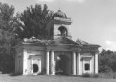
Pulkovo area
PULKOVO, an area in the south of St. Petersburg, at the junction of Kievskoe Freeway and the road from the town of Pushkin. It is located on Pulkovo heights. Since the 15th century
|
|
|
|
|
hidden
|
Regiment Settlements (entry)
REGIMENT SETTLEMENTS are places for compact billets of guard regiments inside the city limits in the 18th - early 19th century. They were built in 1739-43 under regular designs specially provided for this purpose (usually the planning included an
|
|
|
|
|