Bibliographies
/
Ленинград: Путеводитель / Сост.: В. А. Витязева, Б. М. Кириков. 2-е изд. Л., 1988
hidden
|
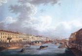
Fontanka, river
FONTANKA (known as Bezymyanny Erik until 1712-14), river, a branch in the Neva river delta, which crosses the central part of the city. The river flows from the Neva on the left, beside the Summer Garden
|
|
|
|
|
hidden
|
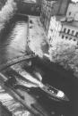
Griboyedova Canal
GRIBOYEDOVA CANAL (the Ekaterininsky Canal in 1767-1923) starts from the Moika River at the Field of Mars and flows into the Fontanka River at Malo-Kalinkin Bridge. It is 5 km long and 32 meters wide with water flow of 3.1 - 3.4 m3
|
|
|
|
|
hidden
|
Irinovsky Avenue
IRINOVSKY AVENUE, running from Boksitogorskaya Street to Kommuny Street, one of the major arteries of the Porokhovye area. The avenue runs parallel to the former Irinovskaya Railroad line (hence the name)
|
|
|
|
|
hidden
|
Krasnogvardeysky District
KRASNOGVARDEYSKY DISTRICT is an administrative territorial unit of St. Petersburg. (Its territory administration is located at 52 Sredneokhtinsky Avenue). It was established in 1973. It was named in honour of the Petrograd Red Guards
|
|
|
|
|
hidden
|
Obvodny Canal
OBVODNY CANAL flows from the Neva River in the area of Alexander Nevsky Lavra to the Ekaterinhofka River (8.08 km long, 21.3 meters wide and 42.6 meters wide in its eastern part)
|
|
|
|
|
hidden
|
Pulkovskoe Freeway
PULKOVSKOE FREEWAY (until 1974, Kievskoe Freeway), from Pobedy Square to the city boundary, forms a continuation of Moskovsky Avenue, goes along the line of Pulkovsky meridian and closes on the dome of the Pulkovo Observatory
|
|
|
|
|
hidden
|
Veteranov Avenue
VETERANOV AVENUE, translated as Veterans' Avenue, between Podvodnika Kuzmina Street and Pionerstroya Street. It was laid in 1960-70s through Dachnoe, Ulyanka, Ligovo, and Sosnovaya Polyana
|
|
|
|
|
hidden
|
Zagorodny Avenue
ZAGORODNY AVENUE, running from Vladimirskaya Square to Moskovsky Avenue. The avenue was laid in the 1740s according to a project planned by the Commission for the Building of St
|
|
|
|
|
|
hidden
|