Bibliographies
/
Никитенко Г. Ю., Соболь В. Д. Василеостровский район: Энцикл. улиц С.-Петербурга. 2-е изд., испр. и доп. СПб., 2002
hidden
|
Birzhevaya Square
BIRZHEVAYA SQUARE, translated as Exchange Square, in 1937-89 - Pushkinskaya Square. The square lies on the spit of Vasilievsky Island between Universitetskaya Embankment and Makarova Embankment
|
|
|
|
|
hidden
|
Bolshoy Avenue of Vasilievsky Island
BOLSHOY AVENUE OF VASILIEVSKY ISLAND, in 1720s-1780s - Bolshaya Prospektivaya or Bolshaya Pershpektivaya Street, in 1918-22 - F. Adlera Avenue, in 1922-44 - Proletarskoy Pobedy Avenue
|
|
|
|
|
hidden
|
Chekushi
CHEKUSHI is an area located in the south-western part of Vasilievsky Island. Its name is known from the first part of the 18th century and is related to "chekushi" or "tokmochi"
|
|
|
|
|
hidden
|
Galley Harbour
GALLEY HARBOUR is an engineering monument from the early 18th century. A rectangular pool located in the western part of Vasilievsky Island in the 18th - early 19th centuries served as a base for naval rowing vessels (galleys, hence the name)
|
|
|
|
|
hidden
|
Kanareechnaya Street
KANAREECHNAYA STREET, running between Bolshoy Avenue and Sredny Avenue of Vasilievsky Island. The street was laid in the 1800s, near Gallery Harbour. It was originally named after house-owner and skipper S. Kanareev (building no
|
|
|
|
|
hidden
|
Kima Avenue
KIMA AVENUE, between the Smolenka River Embankment and Uralskaya Street, on Dekabristov Island. Laid in 1914 during the development of the New Petersburg region
|
|
|
|
|
hidden
|
Lieutenant Schmidt Embankment
LIEUTENANT SCHMIDT EMBANKMENT (until 1887, the Bolshaya Neva Embankment; until 1918, the Nikolaevskaya Embankment), on the right bank of the Bolshaya Neva River, between Seventh Line and Twenty Third Line of Vasilievsky Island. Named after P.P
|
|
|
|
|
hidden
|
Lines of Vasilievsky Island (entry)
LINES Of VASILIEVSKY ISLAND, the historical name of a number of parallel streets that intersect Vasilievsky Island from the south to the north: First to Twenty-Ninth Lines, Birzhevaya Line, Kozhevennaya Line, Kosaya Line, Mendeleevskaya Line
|
|
|
|
|
hidden
|
Makarova Embankment
MAKAROVA EMBANKMENT (until 1887 - Malaya Neva River Embankment, until 1952 - Tuchkova Embankment), between Birzhevaya Square and Smolenka River Embankment, on Vasilievsky Island, on the left bank of the Malaya Neva. The embankment was named after S
|
|
|
|
|
hidden
|
Maly Avenue of Vasilievsky Island
MALY AVENUE Of VASILIEVSKY ISLAND [in the 1730-70s - Third Prospektivaya Street, in the 1780-1800s - Malaya Prospektiva, in 1939-44 - Zheleznyakova Avenue, after the participant of October Revolution and Civil War A.G
|
|
|
|
|
hidden
|
Morskaya Embankment
MORSKAYA EMBANKMENT goes along the aggraded shore of the Gulf of Finland from the square in front of the Pribaltiyskaya Hotel to Nalichnaya Street (the name was given in 1972)
|
|
|
|
|
hidden
|
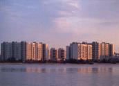
Novosmolenskaya Embankment
NOVOSMOLENSKAYA EMBANKMENT known as Oktyabrskaya Embankment in 1976-87 and Smolenka River Embankment in 1987-89. It was laid downstream the Smolenka River along both banks of the straightened riverbed between Nalichnaya Street and Morskaya
|
|
|
|
|
hidden
|
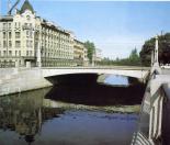
Shkipersky Canal
SHKIPERSKY CANAL (Skippers' Canal) (before 1859, Chernaya Rechka (the Black River) or Glukhoy Protok (the Dead Canal), a small river in the western part of Vasilievsky Island
|
|
|
|
|
hidden
|
Smolenka, river
SMOLENKA, a river, which branches off the Malaya Neva from the left, below Tuchkov Bridge, and flows into the Neva Bay of the Gulf of Finland. The Smolenka separates Vasilievsky Island from Dekabristov Island. The river is 3.3 kilometres long
|
|
|
|
|
hidden
|
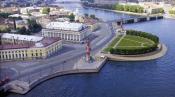
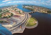
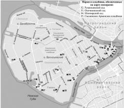
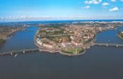
Spit of Vasilievsky Island
SPIT OF VASILIEVSKY ISLAND, a cape in the eastern part of Vasilievsky Island, washed by the Bolshaya Neva and Malaya Neva rivers, the highest part of the island and one of the main architectural ensembles of St. Petersburg. Built to architect D
|
|
|
|
|
hidden
|
Sredny Avenue of Vasilievsky Island
SREDNY AVENUE OF VASILIEVSKY ISLAND (called Malaya Pershpektiva from the 1730s until the 1770s, known as Mussorgskogo Avenue in 1939-44), from Makarova Embankment to Nalichnaya Street
|
|
|
|
|
hidden
|
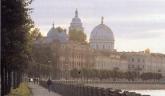
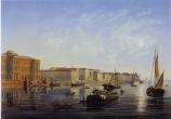
Universitetskaya Embankment
UNIVERSITETSKAYA EMBANKMENT (prior the end of the 18th century, Kadetskaya Embankment, until 1887 - Bolshaya Neva River Embankment), is situated on the right bank of the Bolshaya Neva, between Birzhevaya Square and Sixth Line of Vasilievsky Island
|
|
|
|
|
hidden
|
Vasileostrovsky District
VASILEOSTROVSKY DISTRICT is an administrative territorial unit of St. Petersburg. (Its territory administration is located at 55 Bolshoy Avenue of Vasilievsky Island) Its present-day borders were formed in 1917 (the western part was a separate
|
|
|
|
|
hidden
|
Vasilievsky Island
VASILIEVSKY ISLAND, the largest island in the estuary of the Neva 1,090 hectares in area. The island is washed by the Bolshaya Neva in the south and the Malaya Neva in the northeast
|
|
|
|
|
hidden
|
Veselnaya Street
VESELNAYA STREET (Oar Street), between Bolshoy Avenue and Sredny Avenue of Vasilievsky Island, in the region of the Harbour. The road was built in the 1730s and named Eighth Line and Ninth Line in the early 19th century
|
|
|
|
|
hidden
|
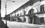
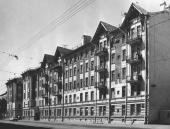
Workers' Towns (entry)
WORKERS' TOWNS. Building complexes which combined housing, educational and service institutions. The construction of workers' towns in Russia started in the 1900s on the initiative of the Association for the Organisation and Improvement of Housing
|
|
|
|
|
|
hidden
|