Addresses
/
Moskovsky Ave/Saint Petersburg, city
hidden
|
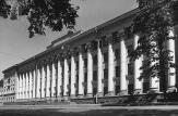
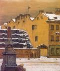
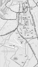
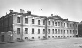
Cadet Corps (entry)
CADET CORPS were military educational secondary boarding schools. Until 1917, they were aimed mainly at the nobility. The education began in cadet corps from the ages of 10-12 (in the 1770s-90s, from 5-8), and lasted seven to fifteen years
|
|
|
|
|
hidden
|
City Clock
CITY CLOCK. The very first mechanical clock in the city was installed in 1704 in the tower of wooden St. Peter and Paul Cathedral. In 1710, the first striker clock (with chimes) was set up on the belfry of the Church of St
|
|
|
|
|
hidden
|
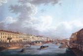
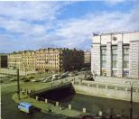
Fontanka, river
FONTANKA (known as Bezymyanny Erik until 1712-14), river, a branch in the Neva river delta, which crosses the central part of the city. The river flows from the Neva on the left, beside the Summer Garden
|
|
|
|
|
hidden
|
Gas Supply Services
GAS SUPPLY SERVICES. The first gas-generating retort installations in Russia appeared in St. Petersburg in the early 19th century. Initially gas was used for lighting. In 1819 the first gas lamps were lit on Aptekarsky Island
|
|
|
|
|
hidden
|
Ilyin L.A. (1880-1942), architect.
ILYIN Lev Alexandrovich (1880-1942), architect, Fellow of the Academy of architecture of the USSR (as of 1941). He studied at the College of Civil Engineers (1897-1909) and at the Academy of Fine Arts (1903-04). He was a member of the Old St
|
|
|
|
|
hidden
|
Katonin E.I. (1889-1984), architect
KATONIN Evgeny Ivanovich (1889–1984), architect, graphic artist, member of the Academy of Architecture of Ukraine (1956). Graduated from the Academy of Fine Arts (1918)
|
|
|
|
|
hidden
|
Krasnoarmeiskie Streets, First - Thirteenth
KRASNOARMEISKAYA STREETS, FIRST - THIRTEENTH (until 1923, the First - Twelfth Roty, and Zarotnaya Street). First - Seventh Krasnoarmeiskaya Streets are located between Moskovsky Avenue and Izmailovsky Avenue; Eighth Krasnoarmeiskaya Street
|
|
|
|
|
hidden
|
Leninsky Avenue
LENINSKY AVENUE, running between Doblesti Street and Moskovskaya Square, part of the Central Circular Highway. It connects Yugo-Zapad and Ulyanka settlement, and Dachny and Moskovsky Avenues. The avenue, named in 1977 after V.I
|
|
|
|
|
hidden
|
Ligovsky Avenue
IGOVSKY AVENUE, running between Nekrasova Street and Moskovsky Avenue. Known as Ligovskaya Street until 1956. Constructed along the Ligovsky Canal track (hence the name) starting in 1891
|
|
|
|
|
hidden
|
Ligovsky Canal
LIGOVSKY CANAL was constructed to supply drinking water to St. Petersburg under the project of Grigory Skornyakov-Pisarev in 1718-21. Originally, it was 23 km long, 2-4 meters bottom-wide and 1-2 meters deep
|
|
|
|
|
hidden
|
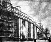
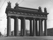
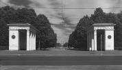
Moscow Triumphal Arch
MOSCOW TRIUMPHAL ARCH built in 1834-38, designed by architect V.P. Stasov, stands on the intersection of Moskovsky Avenue and Ligovsky Avenue in commemoration of the Russian military victories in the Russo-Turkish War of 1828-29
|
|
|
|
|
hidden
|
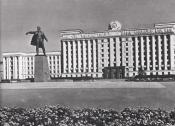
Moskovskaya Square
MOSKOVSKAYA SQUARE, in the south part of Moskovsky Avenue, at its intersection with Leninsky Avenue and Tipanova Street. Occupying the territory of 13 hectares, it is recognised as the largest square in St. Petersburg
|
|
|
|
|
hidden
|
Moskovskaya Zastava
MOSKOVSKAYA ZASTAVA, the historical name of the north part of present-day Moskovsky District. The name originates from the post that existed at the intersection of Moscow road and Ligovsky Canal
|
|
|
|
|
hidden
|
Moskovskoe Freeway
MOSKOVSKOE FREEWAY, between Pobedy Square and line of the Circular Railway, continues Moskovsky Avenue. It appeared in the first quarter of the 18th century as the road to Sarskaya Myza (Tsarskoe Selo) and further on to Novgorod and Moscow (in the
|
|
|
|
|
hidden
|
Moskovsky Avenue
MOSKOVSKY AVENUE (in 1918-50 - Mezhdunarodny Avenue, in 1950-56 - Stalina Avenue, after I.V. Stalin), from Sennaya Square to Pobedy Square, one of the main thoroughfares of St
|
|
|
|
|
hidden
|
Moskovsky District
MOSKOVSKY DISTRICT is an administrative territorial unit of St. Petersburg. (Its territory administration is located at 129 Moskovsky Avenue) It was founded in 1919, and its present-day borders were established in 1965
|
|
|
|
|
hidden
|
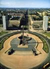
Moskovsky Park of Victory
MOSKOVSKY PARK OF VICTORY (188 Moskovsky Avenue) is located in the south of St. Petersburg, between Moskovsky Avenue and Gagarin Avenue. A project of a district Park of Culture and Recreation
|
|
|
|
|
hidden
|
Novo-Moskovsky Bridge
NOVO-MOSKOVSKY BRIDGE, over Obvodny Canal, along the line of Moskovsky Avenue. The bridge was built in 1808-1816 (architect V.I. Hastie), the span was covered by cast-iron tubbing vaults and rubble abutments faced with granite
|
|
|
|
|
hidden
|
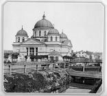
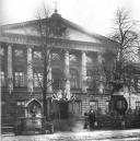
Obukhovskaya Hospital
OBUKHOVSKAYA HOSPITAL (106 Fontanka Embankment) was founded in 1779; originally it had 60 beds and included "Dolgauz,” the first psychiatric institution in the city. It was named after Obukhovsky Avenue and Bridge
|
|
|
|
|
hidden
|
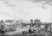
Obukhovsky Bridge
OBUKHOVSKY BRIDGE (in 1738 known as Saarsky, after Saarskaya farmstead - Tsarskoe Selo), over the Fontanka River at Moskovsky Avenue. The bridge was built around 1785-86 on the site of a wooden bridge that had existed here since 1717
|
|
|
|
|
hidden
|
Olympia, the Garden
OLYMPIA, is a garden in the centre of St. Petersburg, on Moskovsky Avenue, between Klinsky Avenue, Malodetskoselsky Avenue and Bataisky Lane. The total area of Olimpiya is 2.7 hectares. It was laid out on the location of Klinsky Market in 1946-47
|
|
|
|
|
hidden
|
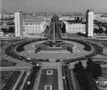
Pobedy Square
POBEDY SQUARE located at the intersection of Moskovsky Avenue, Moskovskoe Freeway, Pulkovskoe Freeway and Krasnoputilovskaya Street, and Ordzhonikidze Street. Until 1962
|
|
|
|
|
hidden
|
Pulkovskoe Freeway
PULKOVSKOE FREEWAY (until 1974, Kievskoe Freeway), from Pobedy Square to the city boundary, forms a continuation of Moskovsky Avenue, goes along the line of Pulkovsky meridian and closes on the dome of the Pulkovo Observatory
|
|
|
|
|
hidden
|
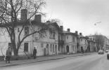
Regiment Settlements (entry)
REGIMENT SETTLEMENTS are places for compact billets of guard regiments inside the city limits in the 18th - early 19th century. They were built in 1739-43 under regular designs specially provided for this purpose (usually the planning included an
|
|
|
|
|
hidden
|
Relief
RELIEF. Despite having a general plain character, its flatness and large built up areas, the relief of St. Petersburg is diverse and full of contrasts. The highest peaks in the southwest of the city reach 176 meters
|
|
|
|
|
hidden
|
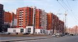
Residential Blocks (entry)
RESIDENTIAL BLOCKS, a site development system typical for new city districts built in the 1920-30s. Due to an acute demand for accommodations in the mid-1920s, individual home building was replaced by residential blocks - a new type of city
|
|
|
|
|
hidden
|
Semenovsky Life Guards Regiment
SEMENOVSKY LIFE GUARDS REGIMENT, one of the two oldest infantry guards regiments (along with Preobrazhensky Life Guards Regiment), its history dates back to 1683 (from "poteshny (toy, amusement) regiments" of Tsar Peter the Great)
|
|
|
|
|
hidden
|
Sementsy, area
SEMENTSY, the historical name of the area between Zagorodny Avenue and Obvodny Canal. The name comes from the 18th century settlement of Semenovsky Life Guard Regiment that was quartered on the territory from Zvenigorodskaya Street to Moskovsky
|
|
|
|
|
hidden
|
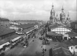
Sennaya Square
SENNAYA SQUARE (from 1952 to 1991 - Mira Square), located at the intersection of Sadovaya Street (some buildings numbered) and Moskovsky Avenue. The St. Petersburg Construction Commission proposed the construction of an extensive square on this site
|
|
|
|
|
hidden
|
Shcherbin V. N. (1930-1996), architect
SHCHERBIN Vladimir Nikolaevich (1930 - 1996, St. Petersburg), architect, painter, graphic artist. Graduated from the Academy of Fine Arts (1954). The author of the residential projects in Nevsky district, Kupchino
|
|
|
|
|