Addresses
/
Bolshoy Ave of Petrograskaya Storona/Saint Petersburg, city
hidden
|
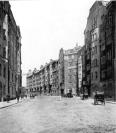
Bolshoy Avenue of Petrogradskaya Side
BOLSHOY AVENUE OF PETROGRADSKAYA SIDE, in the 18th century - Bolshaya Road, Bolshaya Garnizonnaya Road, Bolshaya Ofitserskaya Street, in 1919-44 - K. Libknekhta Avenue. It lies between Dobrolyubova Avenue and Karpovka River Embankment
|
|
|
|
|
hidden
|
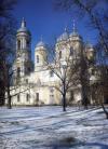
Cathedral of Prince St. Vladimir
CATHEDRAL OF PRINCE ST. VLADIMIR, (Dobrolyubova Avenue, 26 Blokhina Street), an architectural monument in a transitional style from Baroque to Classicism. The Cathedral is located on the so-called mokrushi, soggy, regularly flooded lowland
|
|
|
|
|
hidden
|
Dobrolyubova Avenue
DOBROLYUBOVA AVENUE, running from Kronverksky Avenue to Bolshoy Avenue of the Petrogradskaya Side. Laid in the 1860s along the route of a filled-in section of the Zhdanovka River
|
|
|
|
|
hidden
|
Kamennoostrovsky Avenue
KAMENNOOSTROVSKY AVENUE, located between Troitskaya Square and the Bolshaya Nevka River Embankment. The main thoroughfare joining the city centre and the Petrogradskaya Side with Aptekarsky Island and Kamenny Island
|
|
|
|
|
hidden
|
Krasnogo Kursanta Street
KRASNOGO KURSANTA STREET (until 1923, Bolshaya Spasskaya Street), located between Bolshoy Avenue of the Petrogradskaya Side and Novoladozhskaya Street. Appeared in the 1720s, in what was then the Nevsky Garrison Regiment settlement (until 1727
|
|
|
|
|
hidden
|
Lenina Street
LENINA STREET, running between Sytninskaya Street and Levashovsky Avenue, on the Petrogradskaya Side. Known as Shirokaya Street until 1923. In 1956, it included the former Y. Kalinina Street (until 1923, Matveevskaya Street)
|
|
|
|
|
hidden
|
Leo Tolstoy Square
LEO TOLSTOY SQUARE, at the intersection of Bolshoy Avenue of Petrogradskaya Side and Kamennoostrovsky Avenue. The square was named in the 1920s after the neighbouring street of the same name (since 1798 - Arkhiereiskaya Square
|
|
|
|
|
hidden
|
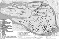
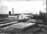
Petrogradskaya Side
PETROGRADSKAYA SIDE (in the 18th century - Gorodskaya Side, until 1914 - Peterburgskaya Side), the joint name of the territory that includes the following islands: Petrogradsky, Aptekarsky, Petrovsky and Zayachy
|
|
|
|
|
hidden
|
Petrogradsky District
PETROGRADSKY DISTRICT, an administrative and territorial unit of St. Petersburg, with its administration located at 19 Bolshaya Monetnaya Street. The district was formed in 1917, and in 1936 the Primorsky District was separated from its territory
|
|
|
|
|
hidden
|
Petrogradsky Island
PETROGRADSKY ISLAND situated between the Neva River, Kronverksky Strait, Malaya Neva River, Zhdanovka River, Malaya Nevka River, Karpovka River, and Bolshaya Nevka River. It is 635 hectares in area, 4.2 kilometres long, and 2.5 kilometres wide
|
|
|
|
|
hidden
|
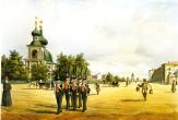
Restaurants (entry)
RESTAURANTS, appeared in St. Petersburg in the early 19th century. The first "auberge," also called a tavern (see Traktirs), was located at the Hotel du Nord on Ofitserskaya Street, and was considered a "restaurant" in 1805
|
|
|
|
|
hidden
|
Sinaisky V.A., (1893-1968), sculptor
SINAISKY Viktor Alexandrovich (1893-1968, Leningrad), sculptor. Studied at the Academy of Arts under V.A. Beklemishev and G.R. Zaleman (1917-20), and A.T. Matveev (1921-22), where he taught on an off between 1921 and 1951, M.K
|
|
|
|
|
hidden
|
Tuchkov Bridge
TUCHKOV BRIDGE (Tyuchkov; Nikolsky), across the Malaya Neva River. The bridge connects the First Line of Vasilievsky Island and Bolshoy Avenue of Petrogradskaya Side
|
|
|
|
|
hidden
|
Vvedenskaya Street
VVEDENSKAYA STREET, from Bolshoy Avenue of Petrogradskaya Side to Kronverksky Avenue. The street was known as Second Vvedenskaya Street in the 1730s-90s; from 1923 to 1944 it was called Rozy Luxemburg Street
|
|
|
|
|
hidden
|
Zhdanovskaya Street and Embankment
ZHDANOVSKAYA EMBANKMENT, running from Bolshoy Avenue of the Petrogradskaya Side to Novoladozhskaya Street. The embankment was formed in the 18th century as a passage along the right bank of the Zhdanovka River
|
|
|
|
|
|
hidden
|
|
hidden
|