hidden
|
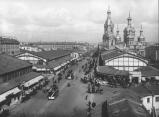
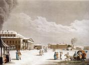
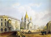
Sennaya Square
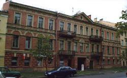
SENNAYA SQUARE (from 1952 to 1991 - Mira Square), located at the intersection of Sadovaya Street (some buildings numbered) and Moskovsky Avenue. The St. Petersburg Construction Commission proposed the construction of an extensive square on this site
|
|
|
|
|
hidden
|
Shkipersky Canal
SHKIPERSKY CANAL (Skippers' Canal) (before 1859, Chernaya Rechka (the Black River) or Glukhoy Protok (the Dead Canal), a small river in the western part of Vasilievsky Island
|
|
|
|
|
hidden
|
Shpalernaya Street
SHPALERNAYA STREET, from Gagarinskaya Street to Rastrelli Square. The street was known as First Line until 1727, then was called First Beregovaya Street. In the late 18th century it assumed the name Voskresenskaya Street or Voskresenskaya Embankment
|
|
|
|
|
hidden
|
Sinopskaya Embankment
SINOPSKAYA EMBANKMENT, on the left bank of the Neva River, from Smolny Avenue to Alexandra Nevskogo Square. In the first half of the 18th century, it was called Naberezhnaya Street or Nevskaya Rozhdestvenskaya Embankment
|
|
|
|
|
hidden
|
Slavy Avenue
SLAVY AVENUE, between Vitebskaya Railway Line and Moskovskaya Railway Line. It was named in 1964 in honour of the military victories and feats of labour of Leningrad citizens
|
|
|
|
|
hidden
|
Smolenka, river
SMOLENKA, a river, which branches off the Malaya Neva from the left, below Tuchkov Bridge, and flows into the Neva Bay of the Gulf of Finland. The Smolenka separates Vasilievsky Island from Dekabristov Island. The river is 3.3 kilometres long
|
|
|
|
|
hidden
|
Smolnaya Embankment
SMOLNAYA EMBANKMENT, from Smolny Avenue to Robespierre Embankment. It received its name in 1887 after Smolny Cathedral (see Cathedral of the Renewal of the Jerusalem Holy Resurrection Temple)
|
|
|
|
|
hidden
|
Solyanoy Lane
SOLYANOY LANE, from Tchaikovskogo Street to Pestelya Street. In the first quarter of the 18th century, a canal was located here which enclosed the area of the Partikulyarnaya (Civil) Shipyard. In the 1730s St
|
|
|
|
|
hidden
|
Sovetskie Streets, First - Tenth
SOVETSKIE STREETS, First - Tenth (were called Rozhdestvenskie Streets from 1798 to 1923, after the Nativity of Our Lord Church, with the present-day name given on occasion of the 6th anniversary of the October Revolution of 1917)
|
|
|
|
|
hidden
|
Soyuza Pechatnikov Street
SOYUZA PECHATNIKOV STREET, from Kryukov Canal to Kulibina Square. Starting from 1739, the street bore the name Bolshaya Matrosskaya Street, renamed Torgovaya Street in 1776
|
|
|
|
|
hidden
|
Sredny Avenue of Vasilievsky Island
SREDNY AVENUE OF VASILIEVSKY ISLAND (called Malaya Pershpektiva from the 1730s until the 1770s, known as Mussorgskogo Avenue in 1939-44), from Makarova Embankment to Nalichnaya Street
|
|
|
|
|
hidden
|
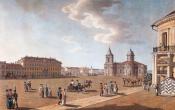
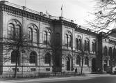
St. Isaac Square
St.ISAAC SQUARE (St. Isaac’s Square, in 1923-44, Vorovskogo Square), one of the central squares of St. Petersburg. Located between Admiralteisky Avenue and Mariinsky Palace
|
|
|
|
|
hidden
|
Stachek Avenue
STACHEK AVENUE, called Petergofskoe Highway until 1923, then known as Stachek Street until 1940, between Stachek Square and the place where Marshala Zhukova Avenue and Petergofskoe Freeway intersect
|
|
|
|
|
hidden
|
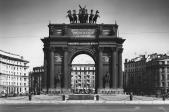
Stachek Square
STACHEK SQUARE, known as Narvskaya Square until 1923, at the intersection of Stachek Avenue, Narvsky Avenue and Staro-Petergofsky Avenue. The square assumed the present-day name in commemoration of the strike movement (the name of the square
|
|
|
|
|
hidden
|
Staro-Petergofsky Avenue
STARO-PETERGOFSKY AVENUE, called Yunogo Proletariya Avenue from 1922 to 1933, then known as Gaza Avenue until 1991, in honour of I.I. Gaza, a Bolshevist and a worker of Putilov Plant (1894-1933). It leads from the Fontanka River to Stachek Square
|
|
|
|
|
hidden
|
Suvorovsky Avenue
SUVOROVSKY AVENUE, from Nevsky Prospect to Proletarskoy Diktatury Square. The avenue was laid in the mid-18th century. It ran from the Elephant Yard (a menagerie) which used to occupy the site of the present-day Oktyabrskaya Hotel
|
|
|
|
|
hidden
|
Sverdlovskaya Embankment
SVERDLOVSKAYA EMBANKMENT (in 1887-1925 - Polyustrovskaya Embankment, after the area of Polyustrovo), on the right bank of the Neva River, between Arsenalnaya Street and Krasnogvardeiskaya Square. It was named after Y.M. Sverdlov
|
|
|
|
|
hidden
|
Svetlanovsky Avenue
SVETLANOVSKY AVENUE, between Svetlanovskaya Square and Suzdalsky Avenue. The avenue was built in the first half of the 20th century. In the 1910s, the lot between modern Toreza Avenue and Jacques Duclos Street was constructed and given the name
|
|
|
|
|
hidden
|
Tavricheskaya Street
TAVRICHESKAYA STREET, called Sadovaya Street from the 1820s to 1859, and known as Slutskogo Street from 1918 to 1944, from Suvorovsky Avenue to Shpalernaya Street. The street was laid in the mid-18th century
|
|
|
|
|
hidden
|
Tchaikovskogo Street
Tchaikovskogo STREET, from Fontanka River Embankment to Potemkinskaya Street. The street was laid in the first half of the 18th century and originally called Second Artilleryskaya Street, sometimes also referred as Second Pushkarskaya Street
|
|
|
|
|
hidden
|
Teatralnaya Square
TEATRALNAYA SQUARE, known as Karuselnaya Square until the 1780s, surrounded by Griboedova Canal Embankment, Kryukov Canal Embankment, Dekabristov Street, Glinki Street and Soyuza Pechatnikov Street. The square was built in the 1760s
|
|
|
|
|
hidden
|
Tikhoretsky Avenue
TIKHORETSKY AVENUE, called Benua Avenue from 1909 to 1952, from Gidrotekhnikov Street to Severny Avenue. The avenue was laid in the early 20th century within the limits of Sosnovka and named after architect Y.Y
|
|
|
|
|
hidden
|
Toreza Avenue
TOREZA AVENUE, called Staro-Pargolovsky Avenue until 1964, from Muzhestva Square to the intersection of Engelsa Avenue and Severny Avenue. The avenue was laid in the 18th century and led towards Pargolovo (hence the original name)
|
|
|
|
|
hidden
|
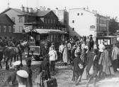
Traktornaya Street
TRAKTORNAYA STREET, from Stachek Avenue to Sivkov Lane. The street was laid on the place of Krylova Lane and named so in 1926 in commemoration of the output of the first tractors at the Krasny Putilovets plant (present-day Kirov Plant)
|
|
|
|
|
hidden
|
Troitskaya Square
TROITSKAYA SQUARE, called Kommuny Square from 1918 to 1923, then known as Revolyutsii Square until 1991, between Kamennoostrovsky Avenue and Kuybysheva Street. The square appeared in the early 18th century on Gorodskoy (present-day Petrogradsky)
|
|
|
|
|
hidden
|
Troitsky Avenue
TROITSKY AVENUE, from Izmaylovsky Avenue to Lermontovsky Avenue; the avenue is the extension of First Krasnoarmeyskaya Street. In the late 18th century, the avenue was known as First Street, called Troitskaya Street from the 1830s (Troitsky Avenue)
|
|
|
|
|
hidden
|
Truda Square
TRUDA SQUARE, known as Blagoveshchenskaya Street from the 1830s to the 1880s, then called Blagoveshchenskaya Square until 1918. The square is surrounded by Angliiskaya Embankment, Konnogvardeysky Boulevard
|
|
|
|
|
hidden
|
Turgeneva Square
TURGENEVA SQUARE, Pokrovskaya Square until 1923, at the intersection of Sadovaya Street (the numeration of the buildings on the square follows the numerical order set on Sadovaya Street) and Angliisky Avenue; the square is the centre of Kolomna area
|
|
|
|
|
hidden
|
Tverskaya Street
TVERSKAYA STREET, called Ofitserskaya Street from the 1770s to 1859, from Tavricheskaya Street to Proletarskoy Diktatury Square. It was renamed in honour of one of the cities of central Russia, Tver, as a number of other streets in this district
|
|
|
|
|
hidden
|
Universitetskaya Embankment
UNIVERSITETSKAYA EMBANKMENT (prior the end of the 18th century, Kadetskaya Embankment, until 1887 - Bolshaya Neva River Embankment), is situated on the right bank of the Bolshaya Neva, between Birzhevaya Square and Sixth Line of Vasilievsky Island
|
|
|
|
|