hidden
|
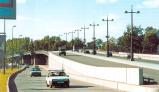
Ushakovskaya Embankment
USHAKOVSKAYA EMBANKMENT, on the right bank of the Bolshaya Nevka River, from Chernaya Rechka River Embankment to Akademika Krylova Street. The embankment is an extension of Vyborgskaya Embankment
|
|
|
|
|
hidden
|
Veselnaya Street
VESELNAYA STREET (Oar Street), between Bolshoy Avenue and Sredny Avenue of Vasilievsky Island, in the region of the Harbour. The road was built in the 1730s and named Eighth Line and Ninth Line in the early 19th century
|
|
|
|
|
hidden
|
Veteranov Avenue
VETERANOV AVENUE, translated as Veterans' Avenue, between Podvodnika Kuzmina Street and Pionerstroya Street. It was laid in 1960-70s through Dachnoe, Ulyanka, Ligovo, and Sosnovaya Polyana
|
|
|
|
|
hidden
|
Vladimirskaya Square
VLADIMIRSKAYA SQUARE, in 1739 - Torgovaya Square, in 1923-50 - Nakhimsona Square after revolutionary S. M. Nakhimson (1885-1918). The square is bounded by Zagorodny Avenue, Vladimirsky Avenue, Kuznechny Lane, Kolokolnaya Street
|
|
|
|
|
hidden
|
Vladimirsky Avenue
VLADIMIRSKY AVENUE, a part of Liteiny Avenue in 1739-1860 also named Vladimirskaya Street from the late 18th century and Nakhimsona Avenue in 1918-44. It runs between Vladimirskaya Square and Nevsky Avenue
|
|
|
|
|
hidden
|
Vosstaniya Square
VOSSTANIYA SQUARE (translated as Uprising Square) known as Znamenskaya Square until 1918 lies at the intersection of Nevsky Prospect and Ligovsky Avenue. The first name translated as Holy Sign Square originated from the Holy Sign Church
|
|
|
|
|
hidden
|
Vosstaniya Street
VOSSTANIYA STREET known as Znamenskaya (Holy Sign) Street until 1923, named after the Holy Sign Church. The street runs between Nevsky Prospect and Kirochnaya Street. The present-day name is in memory of the February Revolution of 1917
|
|
|
|
|
hidden
|
Voznesensky Avenue
VOZNESENSKY AVENUE, translated as Ascension Avenue, between Admiralteisky Avenue and Fontanka River Embankment. It was laid in the early 18th century. It runs towards the tower of the Main Admiralty and crosses St Isaac’s Square
|
|
|
|
|
hidden
|
Vvedenskaya Street
VVEDENSKAYA STREET, from Bolshoy Avenue of Petrogradskaya Side to Kronverksky Avenue. The street was known as Second Vvedenskaya Street in the 1730s-90s; from 1923 to 1944 it was called Rozy Luxemburg Street
|
|
|
|
|
hidden
|
Vyborgskaya Embankment
VYBORGSKAYA EMBANKMENT on the right bank of the Bolshaya Nevka River between Maly Sampsonievsky Avenue and Chernaya Rechka Embankment. The name originated from Vyborgskaya Side in 1887
|
|
|
|
|
hidden
|
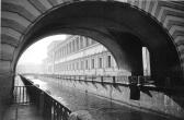
Winter Canal
WINTER CANAL was dug from the Palace Embankment to the Moika river embankment by the contractor V. Ozerov (228 meters long, about 20 meters wide, average waterflow of 2m3/s) in 1718-19
|
|
|
|
|
hidden
|
Yakornaya Square
YAKORNAYA SQUARE in Kronstadt, the central square of the town, limited by the ravine of Petrovsky Dock, the wall of the Admiralty and Obvodny Canal. The square appeared in 1754 as the place for the storage of anchors and anchor chains (hence the
|
|
|
|
|
hidden
|
Yakubovicha Street
YAKUBOVICHA STREET, called Novo-Isaakievskaya Street until 1923, after St. Isaac's Cathedral, running between Isaakievskaya Square and Truda Square. The street was named after Decembrist A.I. Yakubovich (1792-1845)
|
|
|
|
|
hidden
|
Yury Gagarin Avenue
YURY GAGARIN AVENUE, between Blagodatnaya Street and Moskovskoe Freeway. From the 1910s to 1961 the avenue bore the name Narymsky Avenue, after the village of Narym in Tomskaya Region
|
|
|
|
|
hidden
|
Zagorodny Avenue
ZAGORODNY AVENUE, running from Vladimirskaya Square to Moskovsky Avenue. The avenue was laid in the 1740s according to a project planned by the Commission for the Building of St
|
|
|
|
|
hidden
|
Zakharyevskaya Street
ZAKHARYEVSKAYA STREET, running from Liteiny Avenue to Potemkinskaya Street. The street was laid in the first third of the 18th century, in the area surrounding Liteiny Yard
|
|
|
|
|
hidden
|
Zanevsky Avenue
ZANEVSKY AVENUE, located on the right bank of the Neva River, extends from Malookhtinsky Avenue to Soedinitelnaya Railway Line, running through Malaya Okhta and Yablonevka
|
|
|
|
|
hidden
|
Zhdanovskaya Street and Embankment
ZHDANOVSKAYA EMBANKMENT, running from Bolshoy Avenue of the Petrogradskaya Side to Novoladozhskaya Street. The embankment was formed in the 18th century as a passage along the right bank of the Zhdanovka River
|
|
|
|
|
hidden
|
Zhukovskogo Street
ZHUKOVSKOGO STREET, running from Liteiny Avenue to Ligovsky Avenue. Previously known as Malaya Italyanskaya Street, the street assumed its present-day name in 1902 in commemoration of the 50th anniversary of the death of V.A. Zhukovsky
|
|
|
|
|
|
hidden
|
|
hidden
|
|
hidden
|
|
hidden
|
|
hidden
|
|
hidden
|
|
hidden
|
|
hidden
|
|
hidden
|
|
hidden
|
|
hidden
|