Authors
/
hidden
|
Administrative Division
ADMINISTRATIVE DIVISION, division of the city into separate parts (districts) governed by their own administrative organs subordinated to the city administration
|
|
|
|
|
hidden
|
Admiralteisky District
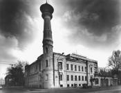
ADMIRALTEISKY DISTRICT, (Admiralty) an administrative territorial unit of St. Petersburg (Its territory administration is located at 10 Izmailovsky Avenue), is one of the central districts of the city
|
|
|
|
|
hidden
|
Admiralteyskaya Side
ADMIRALTEYSKAYA SIDE, a historical name of the central part of St. Petersburg bound on the north by the Neva river and on the south by the Moika River. Formed in the early 18th century when the General Admiralty
|
|
|
|
|
hidden
|
Admiralteysky Islands
ADMIRALTEYSKY ISLANDS, two islands, first and second, situated in the centre of St. Petersburg between the Bolshaya Nevka River and the Moika River. The first Admiralteysky Island is between Lebyazhy Canal and Winter Canal and Second Admiralteysky
|
|
|
|
|
hidden
|
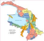
Alexandrovskaya (Kurortny District)
ALEXANDROVSKAYA, locality in the southern part of Sestroretsk, bordering on Gorsky Stream on the south and Lake Sestroretsky Razliv on the north, taking up either side of Primorskoe Freeway
|
|
|
|
|
hidden
|
Alexandrovskaya (Pushkinsky District)
ALEXANDROVSKAYA, municipal unit within the structure of Pushkinsky District of St. Petersburg, located on the banks of the Kuzminka River. The settlement also comprises a railway station of the same name
|
|
|
|
|
hidden
|
Alexandrovskoe, region
ALEXANDROVSKOE, an area to the south-east of St. Petersburg, confined by Zaporozhskaya Street, Moskovskaya Line of Oktyabrskaya Railway, Alexandrovskoy Fermy Avenue, Novo-Alexandrovskaya Street and the Neva River
|
|
|
|
|
hidden
|
Alexandrovsky Parade Ground
ALEXANDROVSKY PARADE GROUND, the historical name of the territory in the south-west of the city center, around the Alexander Nevsky Lavra, north of Obvodnoy Canal and west of the Monastyrka River
|
|
|
|
|
hidden
|
Aptekarsky Island
APTEKARSKY ISLAND, (Apothecary Island), situated in the estuary of the Neva River between the Karpovka River separating it from Petrogradsky Island, Malaya Nevka River, and Bolshaya Nevka River. It is 198 hectares in area, 2.7 kilometres long and 1
|
|
|
|
|
hidden
|
Aviagorodok
AVIAGORODOK, an area in St. Petersburg's Moskovsky District, in the southern part of the city, west of Pulkovskoe Highway and near the Airport Railway Station. In 1931-41, it was Leningrad's main airport and included a living bloc for its staff
|
|
|
|
|
hidden
|
Avtovo
AVTOVO, an area in the southwest part of St. Petersburg, bordered by the Krasnenkaya River on the south and Komsomolskaya Square on the north. The name origin traces back to the Finnish village of Autovo (Auktovo)
|
|
|
|
|
hidden
|
Belevskoe Field
BELEVSKOE FIELD, an area to the south-east of St. Petersburg, confined with Alexandrovskoy Fermy Avenue, Sedova Street, Krasnykh Zor Boulevard and Moskovskaya Line of Oktyabrskaya Railway
|
|
|
|
|
hidden
|
Beloostrov
BELOOSTROV, a municipal unit (since 1998) forming a part of Kurortny District of St. Petersburg, 30 km to the north-west of the city centre, on the banks of the Sestra River, 3 km upstream from the place where it flows into Sestroretsky Razliv Lake
|
|
|
|
|
hidden
|
Bely Island
BELY ISLAND, artificial island at the mouth of the Bolshaya Neva River. It was built by reclaiming the so-called Bely Shoal in the mid-20th century. It is 55 hectares in area, one kilometre long, and 600 metres wide
|
|
|
|
|
hidden
|
Berezovy Island
BEREZOVY ISLAND, 1) named Petrogradsky Island until the early 18th century, which is accurately translated from the Finnish name of Koivusaari. 2) From 1799, the name Berezovy Island was transferred to the small island about one hectare in area
|
|
|
|
|
hidden
|
Bezymyanny Island
BEZYMYANNY ISLAND, large territory over 16 square kilometres in area situated in the centre of St. Petersburg between the Neva, Monastyrka River, Obvodny Canal, Fontanka River, and Ekaterinhofka River
|
|
|
|
|
hidden
|
Bolshaya Okhta, locality
BOLSHAYA OKHTA, a locality in the east of St. Petersburg, on the right bank of the Neva River, surrounded by the Okhta River, Energetikov Avenue and Revolyutsii Freeway
|
|
|
|
|
hidden
|
Buyans (entry)
BUYANS, is the common name of the small, often artificial, islands that were used to accommodate warehouses for various goods easily transportable by water between the 18th and the early 20th century
|
|
|
|
|
hidden
|
Bychy Island
BYCHY ISLAND situated between the Bolshaya Nevka River, Srednaya Nevka River, and Grebnoy Canal. It is 14 hectares in area, 800 meters long and 200 metres wide
|
|
|
|
|
hidden
|
City Sides (entry)
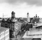
CITY SIDES (St. Petersburg City Sides), a general name of St. Petersburg historical districts, which emerged in the early 18th century. Determined by St. Petersburg's location on different banks (sides) of the Neva River
|
|
|
|
|
hidden
|
Dachnoe
DACHNOE, an area in the south-west part of St. Petersburg, between Krasnenkaya River, Baltiiskaya Railway Line, Stachek Avenue and Alexandrino Forest Park. In the north, it borders Avtovo, in the south-west Ulyanka
|
|
|
|
|
hidden
|
Dibuny, area
DIBUNY, an area in the west part of Pesochny municipal unit, on the right bank of the Chernaya River. There is a railway station of the same name. The toponym originates from the Old Russian word "dybun" meaning swamp or bog
|
|
|
|
|
hidden
|
Dolgoe Lake
DOLGOE LAKE, one of the largest residential areas. Located in the North-West of St. Petersburg, it neighbours Kolomyagi in the east, Commandant's Aerodrome in the southeast and Yuntolovo Forest Estate in the west
|
|
|
|
|
hidden
|
Dyuny (Dunes), area
DYUNY (Dunes), an area in the north part of Sestroretsk, on the coast of the Gulf of Finland. The name is conditioned by the terrain structure: sand-dunes covered with a pine forest
|
|
|
|
|
hidden
|
Ekaterinhofsky Island
EKATERINHOFSKY ISLAND washed by the Ekaterinhofka River, Tarakanovka River, and Bumazhny Canal. It is 40 hectares in area and 700 metres long and wide. The island formed after Bumazhny Canal was built in the second half of the 18th century
|
|
|
|
|
hidden
|
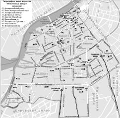
Election districts
ELECTION DISTRICTS. There are two types of election districts on the territory of St. Petersburg: for the purpose of elections of deputies of the Legislative Assembly of St
|
|
|
|
|
hidden
|
Five Corners
FIVE CORNERS, a traditional informal name of the crossroads, formed by Zagorodny Avenue, Lomonosova Street (former Chernyshev Lane), Rubinstein Street (former Troitskaya Street) and Razyezzhaya Street. Appeared in the 1760s
|
|
|
|
|
hidden
|
Forts
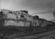
FORTS. Fortifications in the area of the Gulf of Finland, built with the purpose of guarding approaches by the enemy to the Kronstadt Fortress. The first Kronschlot sea fort was opened in 1704
|
|
|
|
|
hidden
|
Frunzensky District
FRUNZENSKY DISTRICT, an administrative and territorial unit of St. Petersburg, with its administration located at 46 Prazhskaya Street. Formed in 1936, it was named in honour of Soviet statesman and military commander M. V
|
|
|
|
|
hidden
|
Galerny Island
GALERNY ISLAND, (Galley Island), situated at the mouth of the Fontanka River about ten hectares in area. The island was extended to the north by narrowing the right branch of the Fontanka River in the late 18th century
|
|
|
|
|