hidden
|
Ulyanka
ULYANKA, an area to the south-west of St. Petersburg; in the north-east, it borders on Dachnoe (divided from it with Alexandrino forest park); in the west, it is confined with Marshal Zhukov Avenue, in the south - with Narodnogo Opolcheniya Avenue
|
|
|
|
|
hidden
|
Uritsk
URITSK, a former separate town within the Leningrad Region. Founded in 1925, and named after М. S. Uritsky, the town stretched along the territory of the present-day Krasnoselsky District, west of Ligovo
|
|
|
|
|
hidden
|
Ushkovo, village
USHKOVO (until 1948 Tyurisevya), formerly a village, since 1998 - a municipal unit of Kurortny District, 49 km to the north-west of St. Petersburg, in the resort area on the north coast of the Gulf of Finland; a railway station
|
|
|
|
|
hidden
|
Ust-Izhora, settlement
UST-IZHORA, an urban settlement (1938), within the Kolpinsky District (1952), on the left bank of the Neva River, where it meets the Izhora River (hence the name)
|
|
|
|
|
hidden
|
Ust-Slavyanka
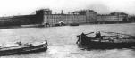
UST-SLAVYANKA, an area to the south-east of Rybatskoe, on the right bank of the Slavyanka River, where it flows into the Neva River. The name appeared before the foundation of St. Petersburg
|
|
|
|
|
hidden
|
Utkina Zavod
UTKINA ZAVOD, a locality in southeast of Saint Petersburg, on the Neva River's right bank, just above the Utka River Estuary, along the Oktyabrskaya Embankment
|
|
|
|
|
hidden
|
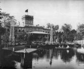
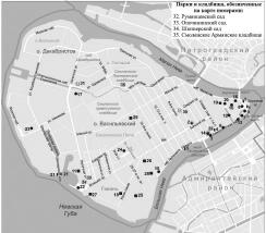
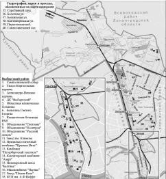
Vasileostrovsky District
VASILEOSTROVSKY DISTRICT is an administrative territorial unit of St. Petersburg. (Its territory administration is located at 55 Bolshoy Avenue of Vasilievsky Island) Its present-day borders were formed in 1917 (the western part was a separate
|
|
|
|
|
hidden
|
Vesely Poselok
VESELY POSELOK, an area in the south-east of St. Petersburg, on the right bank of the Neva River, between Dybenko Street, Bolshevikov Avenue and Novoselov Street
|
|
|
|
|
hidden
|
Volkova Village
VOLKOVA VILLAGE, an area to the south of Obvodny Canal, between Moscow Line and Vitebsk Line of Oktyabrskaya Railway, on the banks of the Volkovka River. Since the early 16th century, there was a Novgorod settlement
|
|
|
|
|
hidden
|
Volodarsky, village
VOLODARSKY VILLAGE (until 1918 - Alexandrovsky village), an area 18 km south-west from the centre of St. Petersburg. Volkhonskoe Freeway joins it with Strelna and Pushkin, while Krasnoselskoe Freeway connects it with Krasnoe Selo
|
|
|
|
|
hidden
|
Volynkina Village
VOLYNKINA, formerly a village, situated by the Ekateringofka River in the area of the intersection of present-day Kalinina Street and Trefoleva Street. From the 15th century, this place was the site of the Finnish village of Vallakula
|
|
|
|
|
hidden
|
Votic Fifth
VOTIC FIFTH (Vodskaya Pyatina), one of five administrative-territorial entities of Novgorod Land, which were subdivided into principalities, regions and districts
|
|
|
|
|
hidden
|
Vozdukhoplavatelny Park
VOZDUKHOPLAVATELNY PARK (Aerostatic Park), the historical name of the territory to the south-west of Volkovaya Village, near the railway station of the same name
|
|
|
|
|
hidden
|
Vyborgskaya Side
VYBORGSKAYA SIDE, a historical district of St. Petersburg, on the right bank of the Neva River and the Bolshaya Nevka River. In the east, it is confined by the Chernaya Rechka River
|
|
|
|
|
hidden
|
Vyborgsky District
VYBORGSKY DISTRICT is an administrative territorial unit of St. Petersburg. (Its territory administration is located at 86 Bolshoy Sampsonievsky Avenue) The district was founded in 1917; and its present-day territorial borders were established in
|
|
|
|
|
hidden
|
Yablonovka
YABLONOVKA, an area close to Ladozhskaya metro station, on the right bank of the Okkervil River. Since 1817, it was known as Bolshaya Yablonka village (since 1831 - Bolshaya Yablonovka). Malaya Yablonovka village was located about 1 km up-stream
|
|
|
|
|
hidden
|
Zastavy (Outposts) (entry)
ZASTAVY (OUTPOSTS), checkpoints, established in the early 18th century on the main roads at the entrance to St. Petersburg to check goods, luggage and to register people, leaving or entering the city
|
|
|
|
|
hidden
|
Zelenogorsk town
ZELENOGORSK (until 1948 Terijoki), the former town, since 1998 - a municipal unit forming a part of Kurortny District of St. Petersburg, 46 km to the north-west of the city, in the resort area on the north coast of the Gulf of Finland
|
|
|
|
|
hidden
|
Zhernovka, locality
ZHERNOVKA, locality in the northern part of St. Petersburg. Its name derived from a former village, known from 1778, which was situated on the left bank of the Zhernovka River (the Lapka) at the place where the Zhernovka converged with the Okhta
|
|
|
|
|