hidden
|
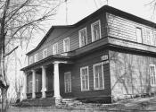
Kolomyagi
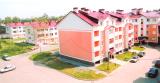
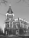
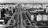
KOLOMYAGI, an area to the north-west of St. Petersburg, north of the Komendantsky Aerodrome and south-west of Ozerki; in the west it is adjacent large-scale residential development of Ozero Dolgoe
|
|
|
|
|
hidden
|
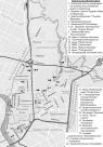
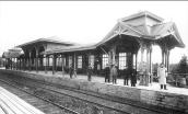
Kolpino town
KOLPINO, a town, the centre of Kolpinsky District of St. Petersburg (since 1936), a station of Oktyabrskaya railway, 26 km to the south-east of St. Petersburg. It occupies the total area of 66 square km. The population is 142,800 people (2000)
|
|
|
|
|
hidden
|
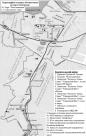
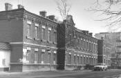
Kolpinsky District
KOLPINSKY DISTRICT, an administrative and territorial unit of Saint Petersburg (with the territorial administration situated in Kolpino, at 1 Uritskogo Street). The name derives from the town of Kolpino which is the centre of the district
|
|
|
|
|
hidden
|
Koltovskie, locality
KOLTOVSKIE, historical name of a region in the western part of Petrogradsky Island between Pionerskaya Street (former Bolshaya Koltovskaya Street), Bolshaya Zelenina Street
|
|
|
|
|
hidden
|
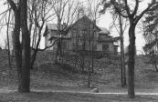
Komarovo, village
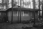
KOMAROVO (until 1948 Kellomaki), the former settlement (since 1946), a municipal unit forming a part of Kurortny District of St. Petersburg (since 1997), 40 km to the north-west of the city
|
|
|
|
|
hidden
|
Komendantsky Aerodrome
KOMENDANTSKY AERODROME, an area in the north-west of St. Petersburg, between Kolomyazhsky Avenue, Parashyutnaya Street, Sizova Street and Chernaya Rechka river
|
|
|
|
|
hidden
|
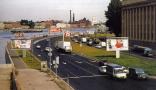
Krasnoe Selo, area
KRASNOE SELO, a town; since 1973, it formed a part of Krasnoselsky District of Leningrad; since 1997 - municipal unit; 26 km to the south-west of St. Petersburg centre, on Narva federal motorway. A railway station on the line St
|
|
|
|
|
hidden
|
Krasnogvardeysky District
KRASNOGVARDEYSKY DISTRICT is an administrative territorial unit of St. Petersburg. (Its territory administration is located at 52 Sredneokhtinsky Avenue). It was established in 1973. It was named in honour of the Petrograd Red Guards
|
|
|
|
|
hidden
|
Krasnoselsky District
KRASNOSELSKY DISTRICT is an administrative territorial unit of St. Petersburg. (Its territory administration is located at 3 Partizana Germana Street) Its present day borders were established in 1973. It was named after the town of Krasnoe Selo
|
|
|
|
|
hidden
|
Krasnye Zori
KRASNYE ZORI, a locality in the East of Petrodvortsovy District between Strelna and New Peterhof, also a railway platform along the Baltiyskaya Railway Line. The name derives from Krasnye Zori labour settlement school
|
|
|
|
|
hidden
|
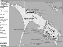
Kronstadt
KRONSTADT, a town on Kotlin Island, 32 kilometres west of Saint Petersburg. The town's history traces back to a sea fort called Kronslot built in the winter of 1703-04. By May 1704, two batteries were constructed along the south bank
|
|
|
|
|
hidden
|
Kronstadtsky District
KRONSTADTSKY DISTRICT is an administrative territorial unit of St. Petersburg (Its territory administration is located at 36 Lenina Avenue,.) Formed in 1998, it was named after the city of Kronstadt, which is the district centre
|
|
|
|
|
hidden
|
Kupchino
KUPCHINO, a region of large scale residential housing in the south of St. Petersburg; it is confined in the north by Fuchika Street, in the east by the Moskovskaya Line of Oktyabrskaya Railway, in the west by a line of Vitebskaya Railway
|
|
|
|
|
hidden
|
Kurort, locality
KURORT, a locality north of the town of Sestroretsk, between the coast of the Gulf of Finland and the Malaya Sestra River, along the Saint Petersburg - Sestroretsk - Beloostrov railway line
|
|
|
|
|
hidden
|
Kurortny District
KURORTNY DISTRICT is an administrative territorial unit of St. Petersburg (Its territory administration is located at 1 Svobody Square) Formed in 1946, the district stretches in a narrow line along the northern coast of the Gulf of Finland for over
|
|
|
|
|
hidden
|
Kushelevka, area
KUSHELEVKA, an area in Vyborgskaya Side, between Karbysheva Street, Nepokorennykh Avenue, Bogoslovskoe Cemetery and Polyustrovsky Avenue. In 1781, Empress Catherine II granted 746 desyatin of land "in Vyborgskaya Side between Pargolova Dacha
|
|
|
|
|
hidden
|
Lakhta, locality
LAKHTA, a landmark northwest of Saint Petersburg, on the northern coast of the Gulf of Finland, in the vicinity of a cognominal railway station and Lake Lakhta; neighbours Olgino on the West, and Staraya Derevnya on the East
|
|
|
|
|
hidden
|
Landskrona
LANDSKRONA (from the Swedish "Landskron", meaning the crown of land), a Swedish fortress, built in 1300 at the confluence of the Okhta River and the Neva River
|
|
|
|
|
hidden
|
Lesnoy
LESNOY, a historical district in the north of St. Petersburg, between Engelsa Avenue to the west, Manchesterskaya Street to the north, Thoreza Avenue and Karbysheva Street to the east and Novorossiiskaya Street to the south
|
|
|
|
|
hidden
|
Levashovo, settlement
LEVASHOVO, a former settlement, north-west of the city centre; since 1997, a municipal unit of the Vyborgsky District of Saint Petersburg. It emerged as a settlement for workers building the Vyborg railway station in 1870
|
|
|
|
|
hidden
|
Levashovskaya Pustosh
LEVASHOVSKAYA PUSTOSH, a tract of land in the vicinity of the Levashovo Railway Station (135 Gorskoe Highway), one of the cemeteries for political victims born in Leningrad
|
|
|
|
|
hidden
|
Ligovo, village
LIGOVO, a historical district in the south-west of St. Petersburg, between Peterhofskoye Highway, Marshala Zhukova Avenue, Baltiiskaya Railway Line and the Ivanovka River
|
|
|
|
|
hidden
|
Lisy Nos, settlement
LISY NOS, a settlement on the northern coast of the Gulf of Finland; municipal unit of the Primorsky Administrative District, former urban settlement (from 1948); also the name of a train station 25 kilometres away from Saint Petersburg
|
|
|
|
|
hidden
|
Lomonosov, town
LOMONOSOV (until 1948 Oranienbaum), a town and municipal unit within Saint Petersburg, the centre of Lomonosovsky District of the Leningrad Region, located 32 kilometres southwest of the city centre on the southern coast of the Gulf of Finland
|
|
|
|
|
hidden
|
Lomonosovsky District
LOMONOSOVSKY DISTRICT, an administrative and territorial unit of St. Petersburg, with its administration located in the town of Lomonosov, at 42 Dvortsovy Avenue
|
|
|
|
|
hidden
|
Malaya Okhta, locality
MALAYA OKHTA, a locality in the eastern part of St. Petersburg, situated on the left bank of the Neva River, above the mouth of the Okhta River. It borders on Soedinitelnaya Railway Line in the north and the Okkervil River in the north-east
|
|
|
|
|
hidden
|
Malinovka
MALINOVKA, formerly a village, located in the northeast of St. Petersburg; known from the late 18th century. It stretched at the place where two rivers of the same name converge (sometimes called Narvin Brook) and the Okhta River (at the
|
|
|
|
|
hidden
|
Martynovka
MARTYNOVKA, a locality in the northwest of St. Petersburg northwards from Kolomyagi. In the late 19th to early 20th centuries there was the summer cottage settlement of Grafskaya intersected by a narrow-track railway connecting Novaya Derevnya and
|
|
|
|
|
hidden
|
Martyshkino
MARTYSHKINO, formerly a settlement, in 1997 it was incorporated into the town of Lomonosov and is located westwards from Old Peterhof; also by the railway station along the line Saint Petersburg - Lomonosov
|
|
|
|
|
hidden
|
Matrosskaya Sloboda
MATROSSKAYA SLOBODA (Sailors' Settlement), a settlement founded in the early 18th century on the right bank of the Okhta River, opposite the confluence of the Okhta River and Okkervil River
|
|
|
|
|