hidden
|
Alexandrovskaya (Kurortny District)
ALEXANDROVSKAYA, locality in the southern part of Sestroretsk, bordering on Gorsky Stream on the south and Lake Sestroretsky Razliv on the north, taking up either side of Primorskoe Freeway
|
|
|
|
|
hidden
|
Alexandrovskaya (Pushkinsky District)
ALEXANDROVSKAYA, municipal unit within the structure of Pushkinsky District of St. Petersburg, located on the banks of the Kuzminka River. The settlement also comprises a railway station of the same name
|
|
|
|
|
hidden
|
Beloostrov
BELOOSTROV, a municipal unit (since 1998) forming a part of Kurortny District of St. Petersburg, 30 km to the north-west of the city centre, on the banks of the Sestra River, 3 km upstream from the place where it flows into Sestroretsky Razliv Lake
|
|
|
|
|
hidden
|
Dibuny, area
DIBUNY, an area in the west part of Pesochny municipal unit, on the right bank of the Chernaya River. There is a railway station of the same name. The toponym originates from the Old Russian word "dybun" meaning swamp or bog
|
|
|
|
|
hidden
|
Dyuny (Dunes), area
DYUNY (Dunes), an area in the north part of Sestroretsk, on the coast of the Gulf of Finland. The name is conditioned by the terrain structure: sand-dunes covered with a pine forest
|
|
|
|
|
hidden
|
Gorskaya
GORSKAYA, locality in the southern part of Sestroretsk, east of Primorskoe Freeway. The territory incorporates a railway station of the same name within the railway line linking St. Petersburg and Sestroretsk and a summer settlement
|
|
|
|
|
hidden
|
Komarovo, village
KOMAROVO (until 1948 Kellomaki), the former settlement (since 1946), a municipal unit forming a part of Kurortny District of St. Petersburg (since 1997), 40 km to the north-west of the city
|
|
|
|
|
hidden
|
Kurort, locality
KURORT, a locality north of the town of Sestroretsk, between the coast of the Gulf of Finland and the Malaya Sestra River, along the Saint Petersburg - Sestroretsk - Beloostrov railway line
|
|
|
|
|
hidden
|
Levashovo, settlement
LEVASHOVO, a former settlement, north-west of the city centre; since 1997, a municipal unit of the Vyborgsky District of Saint Petersburg. It emerged as a settlement for workers building the Vyborg railway station in 1870
|
|
|
|
|
hidden
|
Ligovo, village
LIGOVO, a historical district in the south-west of St. Petersburg, between Peterhofskoye Highway, Marshala Zhukova Avenue, Baltiiskaya Railway Line and the Ivanovka River
|
|
|
|
|
hidden
|
Lisy Nos, settlement
LISY NOS, a settlement on the northern coast of the Gulf of Finland; municipal unit of the Primorsky Administrative District, former urban settlement (from 1948); also the name of a train station 25 kilometres away from Saint Petersburg
|
|
|
|
|
hidden
|
Martyshkino
MARTYSHKINO, formerly a settlement, in 1997 it was incorporated into the town of Lomonosov and is located westwards from Old Peterhof; also by the railway station along the line Saint Petersburg - Lomonosov
|
|
|
|
|
hidden
|
Molodezhnoe
MOLODEZHNOE (until 1948 Yammelyeki), formerly a settlement, from 1998 was attributed the status of a municipal formation within Kurortny District of St. Petersburg, and is located in a resort zone on the northern coast of the Gulf of Finland
|
|
|
|
|
hidden
|
Mozhaysky, settlement
MOZHAYSKY, a former urban settlement, known as Duderhof until 1950; incorporated in 1973 into the Krasnoselsky District of Leningrad. Located 30 kilometres southwest of the city centre
|
|
|
|
|
hidden
|
Olgino, settlement
OLGINO, a summer cottage village 15 kilometres northwest of Saint Petersburg, on the northern coast of the Gulf of Finland, in the vicinity of a cognominal railway platform
|
|
|
|
|
hidden
|
Osinovaya Roshcha (Aspen Grove)
OSINOVAYA ROSHCHA (Aspen Grove), a former settlement north of Pargolovo at the junction of the Vyborgskoe and Priozerskoe Highways. First records of Osinovaya Roshcha trace back to the late18th century
|
|
|
|
|
hidden
|
Pargolovo
PARGOLOVO, a former settlement; since 1997, a municipal unit along the Vyborgskoe Highway, in the Vyborgsлy District of Saint Petersburg; also, a train station. As of 2002, the population count was approximately 4,000 people
|
|
|
|
|
hidden
|
Pesochny, settlement
PESOCHNY, a former settlement, since 1998, a municipal unit within the Kurortny District of Saint Petersburg; 23 kilometres northwest of the city centre; on the Chernaya River, 7 kilometres away from its inflow into Lake Sestroretsky Razliv
|
|
|
|
|
hidden
|
Razliv
RAZLIV, a locality in southern Sestroretsk, north of Tarkhovka, on the western bank of Lake Sestroretsky Razliv; also a railway station along the Saint Petersburg -Sestroretsk line
|
|
|
|
|
hidden
|
Repino, settlement
REPINO, a former settlement, known as Kuokkala until 1948; became a municipal unit within the Kurortny District in 1998; 37 kilometres northwest of Saint Petersburg, in a resort area on the northern coast of the Gulf of Finland; also a train station
|
|
|
|
|
hidden
|
Serovo
SEROVO (until 1948 Vammelsuu), formerly a village, since 1998 - a municipal establishment forming a part of Kurortny District, in the recreational zone on the north coast of the Gulf of Finland
|
|
|
|
|
hidden
|
Smolyachkovo
SMOLYACHKOVO (until 1948 Ino), the former village, since 1998 - a municipal establishment forming part of Kurortny District, in the resort zone on the north coast of the Gulf of Finland, on the boundary with Leningrad Region
|
|
|
|
|
hidden
|
Solnechnoe, settlement
SOLNECHNOE (until 1948 Ollila), formerly a settlement, since 1998, a municipal unit of the Kurortny District, a resort area on the Gulf of Finland's northern coast; also a railway station. As of 2001, the population totalled 1,000 inhabitants
|
|
|
|
|
hidden
|
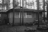
Summer Residences (entry)
SUMMER RESIDENCES, places for recreation during the summer for St. Petersburg residents. Before the construction of railways, well off St. Petersburg residents spent their holidays in owned or rented summerhouses close to the city
|
|
|
|
|
hidden
|
Tarkhovka, locality
TARKHOVKA, a locality south of Sestroretsk, between the Primorskoe Highway and Lake Sestroretsky Razliv. It borders Razliv on the north, and the Alexandrovskaya station on the south; also the name of a train station along the Saint Petersburg -
|
|
|
|
|
hidden
|
Tyarlevo, village
TYARLEVO, formerly a village, from 1998 a municipal division in Pavlovsk administrative district located at the banks of the Tyarlevsky Brook and the Slavyanka River, and adjacent to Pavlovsky Park in the south
|
|
|
|
|
hidden
|
Ushkovo, village
USHKOVO (until 1948 Tyurisevya), formerly a village, since 1998 - a municipal unit of Kurortny District, 49 km to the north-west of St. Petersburg, in the resort area on the north coast of the Gulf of Finland; a railway station
|
|
|
|
|
hidden
|
Volodarsky, village
VOLODARSKY VILLAGE (until 1918 - Alexandrovsky village), an area 18 km south-west from the centre of St. Petersburg. Volkhonskoe Freeway joins it with Strelna and Pushkin, while Krasnoselskoe Freeway connects it with Krasnoe Selo
|
|
|
|
|